
Displaying items by tag: Blue Gum High Forest
Preservation of Blue Gum High Forest in St Ives
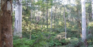
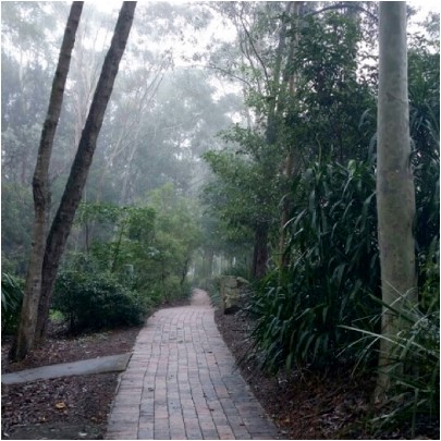
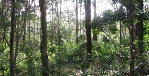
On the high ridges north of Sydney Harbour grew a tall, open forest of blue gums, blackbutts and casuarinas with a moist understorey of shrubs, ferns, creepers and orchids. The largest remnant to survive the timber industry, orchards and spread of suburbs remains at St Ives. Threats of fragmentation necessitate repeated community campaigns to avoid further loss.
In 1925 this remnant of tall forest was purchased as a demonstration forest and named after the commissioner for forests, Dalrymple Hay.
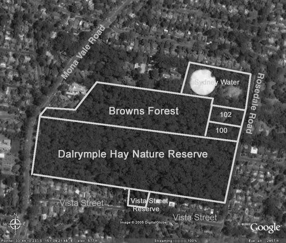
Browns Forest which then extended to surrounding roads, was reduced by subdivision into 1 acre blocks for housing when neither the NSW government nor Ku-ring-gai Council purchased it. What remains was saved by community pressure led by Annie Wyatt of the Ku-ring-gai Tree Lovers’ League, the mayor Cresswell O’Reilly and the Forest Preservation Committee. The 11 acres without a street frontage was purchased in 1934 by council for 1460 pounds, less 310 pounds from the owners if an undertaking was given to dedicate the land as forest reserve. Council completed the purchase with 350 pounds from public donations and covenanted Browns Forest as ‘forest reserve for all time’.
In 1946 land was resumed for water storage although the reservoir was not built until 1974.
100 and 102 Rosedale Road were owned by Prof Room from 1938. He built a house on the uphill part of 102 leaving the remaining portion forested. Following the deaths of Prof Room and his wife the property was sold in 1990 and the new owners submitted to council a nine lot subdivision on the 1 hectare.
People power needed again
Ku-ring-gai Bushland and Environmental Society, the National Trust and the NSW National Parks and Wildlife Service submitted objections, saying, due to the condition of the forest that the land must be purchased for conservation. Council rejected the subdivision but did not have the funds to purchase the land.
In 1997 Blue Gum High Forest was gazetted as an endangered ecological community in Schedule 1 of the NSW Threatened Species Conservation Act 1995.
In 2000 the 1 hectare was sold again and in 2002 a 12 lot subdivision was submitted to council, which was again refused. The owners appealed against council’s decision to the Land and Environment Court. The appeal was dismissed:
… because of its inability to provide a sufficient asset protection zone … and also its impact on the endangered Blue Gum High Forest ecological community.
Yet another development application was submitted in 2004 for a single dwelling on 100 Rosedale Road. By July 2005 council had rejected this development application having received 60 objections.
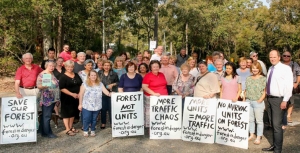
Strong community support was now building for conservation of all of the Blue Gum High Forest at St Ives. A coalition of community organisations, led by STEP Inc, formed the Blue Gum High Forest Group which led walks through the forest, distributed leaflets, gave talks, wrote begging letters seeking donations and lobbied council. Fortunately most councillors were by then wanting to save this 1 hectare of forest but the purchase price was over $2million.
The properties, 100 and 102 Rosedale Road, were advertised by Colliers International for sale on the international market. However, by the closing date at the end of May they had not been sold.
Meanwhile the Blue Gum High Forest Group had surveyed all the remnants of Blue Gum High Forest, and with council, submitted an application to the Commonwealth to list the Blue Gum High Forest ecological community as ‘critically endangered’. Several mayors, NSW and federal politicians, government officials and journalists were walked through the St Ives Blue Gum High Forest.
Breakthroughs in 2005
The Commonwealth Minister for Environment and Heritage announced the listing of the Blue Gum High Forest ecological community as critically endangered. NSW also upgraded the listing.
Half of the 1 hectare was purchased by NSW Rail Infrastructure to offset loss of BGHF due to railway upgrades near Hornsby.
Council agreed to apply for funds from the National Reserve System and this was supported by the Federal Member for Bradfield.
The BGHF Group had raised donations of $72,000 which impressed the councillors.
Yet again, in 2007, another development application was submitted for a house on 102 Rosedale Road and again council rejected it on the grounds of impact on the ‘critically endangered’ Blue Gum High Forest ecological community. Fortunately the Commonwealth contributed $350,000 to assist council’s purchase of this last half hectare of Blue Gum High Forest at St Ives. The whole was added to the National Reserve System which includes protected areas across Australia including national parks, nature reserves, historic sites and private land under voluntary conservation agreements.
It was time for a party. Yet another exhausting battle to prevent loss of another piece of our natural heritage from being destroyed had been won. Community care for the Blue Gum High Forest continues with bushcare groups working with National Parks and Wildlife Service and Ku-ring-gai Council. To join in contact Ku-ring-gai Council.
Click here for more details on the Blue Gum High Forest.
Nancy Pallin
Update on Hills Council Plans for IBM Site
STEP Matters issue 193 provided detail on the application by Mirvac to build 600 apartments in the former IBM business site next to Cumberland State Forest. In addition to the IBM site Mirvac owns a large land area that currently contains high quality bushland.
Hills Shire Council applied to the Department of Planning for a Gateway Determination to allow rezoning of the bushland part of the 28 ha site for R4, high density. The department issued the Gateway Determination on 31 October telling the council to do more homework and amend the zoning plan to provide protection of the high value vegetation.
Lo and behold, Hills Council then wrote a letter to the department on 12 December 2017 requesting an amendment to the Gateway Determination to permit zoning of the high quality bushland as E3, Environmental Management. This would allow the area to be subdivided into 2 ha lots with the associated need to bushfire protection zones, roads, water supply, etc all leading to the destruction of endangered ecological community and threatened species habitat.
Mirvac has advised in writing that they want the area zoned as E2, Environment Conservation, and they are not seeking to impose the cost of this protection on the council. So all the community groups opposed to the development are at a loss to understand why council applied for E3.
Council has also applied for special conditions in the DCP for just this site that are different from the rest of the Hills Council LEP. It also requests the removal of the 2.5 ha recreation zone, saying it could create public open space. Why not commit to providing open space that will be essential for the new residents?
They have requested approval for site specific provisions which would enable a single developer, Mirvac, to build a completely ‘new type of housing’ which has been built nowhere else in the Hills Shire, on 86 m2 blocks, in a zoning which provides for 700 m2 lots.
We await the next decision by the department. Go to www.forestindanger.org.au for the latest news and how to make a submission to council or the Department of Planning.
Planning Debacle of IBM Site in West Pennant Hills
 Back in the 1980s IBM built an office complex at 55 Coonara Road, West Pennant Hills. The building design won several architecture awards. The office environment is idyllic. The buildings are surrounded by an extensive tree canopy including Blue Gum High Forest that is now 25 to 30 years old. IBM worked with the National Trust to establish a bush regeneration plan and 40,000 native plants were planted.
IBM sold the land to property developer Mirvac in August 2010. The buildings were renovated in 2011 and IBM is still a tenant but Mirvac has set out to develop the site to take advantage of the site’s location near the Cherrybrook Metro development precinct.
The total site covers about 28 hectares. It is next to Cumberland State Forest. The IBM buildings are on the northern western part of the site. The southern part contains bushland that is at least 70 years old, some having not ever been cleared but may have been logged in the early days as happened in most of Sydney’s original forests. A large part of this area contains critically endangered Blue Gum High Forest or endangered Sydney Turpentine Ironbark Forest. The forest is Powerful Owl habitat plus there is known habitat for the threatened Dural land snail and two vulnerable microbat species. There hasn’t been a full ecological assessment of the whole site.
Mirvac originally proposed to build 1269 dwellings in the area of the old IBM buildings but negotiations with the Hills Shire Council cut this back to 600 dwellings. The whole site including the southern forest is currently zoned as B7, business park. The proposal was considered by council in July. They decided to submit the plan to the Department of Planning for a Gateway Determination of an amendment to the zoning of the site.
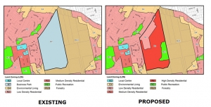
Council proposed that the redevelopment area be zoned as R2 medium density, an existing cleared area be RE1 but the remainder, the high quality bushland area, be zoned as R4 high density residential. Importantly, there was going to be no environmental protection for this area containing a significant area of critically endangered forest.
Once it became known all the local community groups formed a coalition called Forest in Danger to oppose the prospect of this magnificent bushland being covered in high rise apartments. In fact the immediate medium density development will also destroy high quality vegetation. There are several other reasons for rejecting the plans that are listed below.
The basic problem is that the reports from Mirvac and council focused on the development site. There was very little information on the rest of the site and therefore no consideration of fundamental issues with the potential loss of biodiversity.
Not only that, the Department of Planning provided a rezoning review briefing report on the site. It noted that A Plan for Growing Sydney does not identify this land for residential purposes and there is no alternative strategy endorsed by council regarding the site’s future use. So, on top of the issues with loss of the forest there is no justification for the rezoning consistent with a strategic plan for additional housing, employment, retail or other business development and transport infrastructure. Traffic on nearby Castle Hill Road is already severely congested. The claims of proximity to Cherrybrook Metro Station are questionable as the walk is more than the desirable criterion of 800 m from the northern part of the site but more like 2 km from the southern part up a steep hill.
The R4 zoning is proposed for the southern area even though no proper assessment has been made of bushfire management, stormwater and flood prone land on top of the loss of biodiversity. Once the zoning is changed the whole forest would be in danger of destruction.
Gateway Determination
Lots of letters of objection have been sent to the Department of Planning and the Hills Council. The Gateway Determination was made on 31 October. The Department of Planning advised council to give proper consideration to appropriate zoning including environmental zones.
One concern with the determination is the suggestion that there could be an area allocated as a forestry zone. The strange aspect of the determination is that the department is allowing council to conduct consultation with the community on an amended plan before the department has reviewed it. Surely the department should consider the new allocation of zoning in light of the overall strategy for north west development so the community has certainty.
Another community forum was held on 18 November in Cherrybrook. Over 250 people attended and heard a detailed description of the flawed process undertaken so far and of what would be lost if the current zoning were to go ahead. The rezoning plan is opposed by several new councillors on council including the mayor and nearby Hornsby Council.
Summary of Arguments against the Proposal
STEP is strongly opposed to any loss of Blue Gum High Forest (critically endangered) and Sydney Turpentine Ironbark Forest (endangered) no matter how small, as these tiny incremental losses will inevitably lead to their extinction in the long term. This applies to the potential loss in the medium density development area as well as the large areas of these forests in the southern forested areas where the R4 zoning is proposed.
Current Proposal for Medium Density Housing (First Part of the Development)
Asset Protection Zones
The proposed asset protection zone around the development area impacts 0.18 ha of Blue Gum High Forest up to 71 years old, and 0.5 ha of Blue Gum High Forest and Sydney Turpentine Ironbark Forest natural remnant bushland. The NSW Rural Fire Service discourages development in bush fire affected areas that would incur significant environmental costs. There are significant environmental constraints here which are not overcome in this proposal.
Impact of Internal Roads
Currently planned internal roads impact Blue Gum High Forest with a loss of 300 m2 proposed.
Powerful Owl
The impact on Powerful Owl residents would be substantial. These owls need not just peaceful nesting trees and roosting habitat but large areas of trees in which to hunt. Substantial numbers of trees 25 to 30 years old would be cleared for this development and hence reduce hunting opportunities and the probability of owl survival.
Fragmentation of the Forests
The Cumberland State Forest and 55 Coonara Avenue currently form an area of over 60 ha of bushland from the ridge, down to gully habitat. The development and asset protection zone reduce the area of trees and forests and the asset protection zone increases the separation of this site from the Cumberland State Forest. This fragmentation reduces the value of this comparatively large area of remaining Sydney Turpentine Ironbark Forest.
Recommendations
We recommend that the application is rejected in its entirety due to its impact on the environment, particularly Blue Gum High Forest, Sydney Turpentine Ironbark Forest and Powerful Owls. Any possible future development must not have any impact on these endangered communities species and Powerful Owls.
The bulk of this land should at the very least be rezoned to E2 for environmental conservation. Ideally the site should be added to the adjacent Cumberland State Forest and conserved in perpetuity.
More Information
For the latest information on the campaign against the development and more detail on issues with the proposal go to www.forestindanger.org.au.
Email or write to:
- Minister for Planning, Anthony Roberts This email address is being protected from spambots. You need JavaScript enabled to view it.
- Member for Bauklham Hills, David Elliot This email address is being protected from spambots. You need JavaScript enabled to view it.
- Director Sydney West Planning This email address is being protected from spambots. You need JavaScript enabled to view it.
- Hill Shire Council Mayor Michelle Byrne This email address is being protected from spambots. You need JavaScript enabled to view it.
Development Proposal Adjoining Cumberland State Forest
Please consider sending a submission opposing Mirvac's rezoning and development proposal for land adjoining Cumberland State Forest in West Pennant Hills to:
- Minister for the Environment, Gabrielle Upton This email address is being protected from spambots. You need JavaScript enabled to view it.
- Shadow Minister for Environment, Penny Sharpe This email address is being protected from spambots. You need JavaScript enabled to view it.
- Minister for Planning This email address is being protected from spambots. You need JavaScript enabled to view it.
- Hills Shire Council This email address is being protected from spambots. You need JavaScript enabled to view it.
- Member for Baulkham Hills This email address is being protected from spambots. You need JavaScript enabled to view it.
Background
The proposal is to rezone the majority of the 26 hectare site of heavily forested land to R4, high density residential. About 12 hectares on the southern side is of high ecological value containing critically endangered Blue Gum High Forest or endangered Sydney Turpentine Ironbark Forest. The rest of the site contains many mature trees believed to be over 30 years old.
The initial development plan is to allow for 400 apartments and 200 medium density houses in the northern part of the site with associated tree removal for bushfire protection. The proposed rezoning would allow eventual construction of apartment dwellings plus a recreational area on the entire site with no protective environmental zoning. This is a crucial example of the potential destruction under the NSW government’s new Biodiversity Offset laws.
The government is currently considering whether to give this rezoning proposal its in principle blessing under the Pre-Gateway review process and it is expected to be before the Hills Council before the end of the year.
Draft Submission Points
Thank you for the opportunity to make a submission on the proposed amendment to the Hills Local Environment Plan 2012 to facilitate medium to high density development at 55 Coonara Avenue, West Pennant Hills. This proposal is strongly opposed for the reasons outlined below.
- The proposed rezoning to R4 (high density residential) would apply to over 23 hectares that contains critically endangered Blue Gum High Forest and endangered Sydney Turpentine Ironbark Forest but no protective environmental zoning has been proposed. Any high density development would also destroy Powerful Owl habitats. This owl species is listed as a vulnerable species in NSW. An ecological assessment of the site discovered nesting trees and roosting habitats on, and adjacent to the proposed 28 hectare development.
- The initial development plan is to allow for 400 apartments and 200 medium density houses on the northern part of the site. Not only is the proposed development environmentally damaging – it also lacks appropriate infrastructure and amenities, with the nearest public transport link more than a kilometre away up a steep hill. Apart from losing treasured local bushland, neighbouring residents would also have to contend with additional traffic gridlock on local roads, especially Castle Hill Road, as a result of the increased local population.
- The bulk of this land should be rezoned as E2 for environmental conservation with strong protections for mature trees on any part of the site rezoned residential. We want this beautiful rare forest to be protected, not bulldozed for high-density apartments.