
Have your say on the North District Plan and the Greater Sydney Strategy by 31 March 2017.
District Plans cover the plan for growing Greater Sydney in detail. Sydney is divided into six districts and ours is the North District.
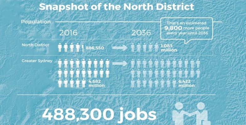
Increase in Number of Dwellings
The table below summarises the implied new dwelling requirements from the population growth rates adopted in the Greater Sydney Strategy.
| Council | Existing 2011 | 2011–16 | 2016–21 | 2021–26 | 2026–31 | 2031–36 | Change 2011–36 | % change 25 years |
| Lane Cove | 13,900 | 1,650 | 1,350 | 1,250 | 1,900 | 1,900 | 8,050 | 58% |
| Ryde | 44,050 | 4,950 | 6,250 | 5,650 | 5,100 | 5,000 | 26,950 | 61% |
| Hunters Hill | 5,400 | 350 | 150 | 150 | 200 | 250 | 1,100 | 20% |
| Northern Beaches | 103,800 | 4,950 | 2,900 | 4,050 | 5,100 | 5,400 | 22,400 | 22% |
| Mosman | 13,750 | 550 | 300 | 250 | 350 | 400 | 1,850 | 13% |
| North Sydney | 37,000 | 2,950 | 2,750 | 2,700 | 3,100 | 2,900 | 14,400 | 39% |
| Willoughby | 29,050 | 1,900 | 1,200 | 1,400 | 1,850 | 2,000 | 8,350 | 29% |
| Ku-ring-gai | 41,050 | 3,150 | 2,750 | 2,850 | 3,300 | 3,250 | 15,300 | 37% |
| Hornsby | n/a as boundaries have changed | |||||||
Here is an example of how the increase in dwelling numbers could come from replacement of existing houses with higher density dwellings. If the average replacement ratio is three new dwellings for one original dwelling in Lane Cove, around 4000 existing homes (around 30% of the suburb) would be replaced by 12,000 new terraces/townhouses over 25 years.
The sheer scale of new housing and infrastructure that will be needed to accommodate the increase in population over the period 2016–36 means that the character of northern Sydney will change. That will not be the end of it. The growth is not expected to stop once 2036 is reached!
The financing for this development could create pressure for sale of public land. Alternatively it could be financed by concessions in the height and location of high-rise. Dwellings near open space (including bushland) are more valuable and provide greater capacity for ‘value capture’. We see this approach in the proposals for development in South Dural where the developer is applying for approval of six storey buildings adjoining a riparian zone.
Protection of Native Vegetation
STEP’s main area of interest is the likely impacts of extensive further development on our existing bushland and native vegetation and what the District Plans have to say about the future development and management of these areas. We are also concerned about the environment of Sydney in general with issues like:
- Will natural bushland on public and private land be maintained and improved?
- Will the green canopy cover from street trees and suburban gardens be maintained?
- Will there be sufficient wildlife corridors and preservation of habitat, eg tree hollows?
- Will the planning regulations allow developers to remove excessive amounts of vegetation?
- Will there be preparation for climate change in management of riparian zones and foreshores?
The North District Plan is a frustrating document. It makes encouraging statements but then provides little detail on how the intentions will be actioned.
It emphasises the rich natural environment of the North District located in national parks and reserves, public and private land (p131).
It states that more effective outcomes can be delivered through planning at a strategic level that:
… can consider opportunities to connect areas of biodiversity, the relationship between different areas and threats to natural features.
Does this mean considering cumulative impacts and wildlife corridors?
The future status of natural areas is unclear. Natural areas that are currently cared for under council plans of management need to continue to have protection as a special category of public land use. The Department of Planning has been reviewing the State Environment Planning Policy 19 that defines protection of urban bushland for well over a year. We should have this information by now so we know how it fits in with the District Plans. We understand that Tree Preservation Orders are included in this review.
The whole process is a quantum change from the past where a regulatory planning system, such as SEPPs protected our natural areas. We now have a strategic planning system which facilitates further development intensity and the strength of the regulatory protection is unclear.
The future conflicts are exemplified by the stated objectives of strategic conservation planning (p132), for example:
- Maintain and where possible improve the conservation status of threatened species and ecological communities.
- Achieve better outcomes for biodiversity conservation.
- Facilitate urban growth and development and reduce the cost and timeframes for development approvals.
- Provide an equitable model recognising and recovering the cost of biodiversity impacts from urban growth (the questionable offsets system).
Specific Issues
Some examples of specific issues that need to be addressed in the North District include:
- Protection of Gordon Flying Fox Reserve – flying foxes are a keystone species that are essential for the cross-pollination of native trees and their ability to adapt to climate change.
- Ensuring critically endangered ecological communities including Blue Gum High Forest and other rare vegetation are protected by the classification as Nature Reserves. These reserves are isolated pockets that are encroached by housing development. Bushland buffers need to be maintained around these endangered forest areas as well measures to ensure that the trees are not damaged by urban stormwater.
- Recognition of the special environmental attributes of the northern areas with unique vegetation arising from high rainfall and Wianamatta Shale Soils.
- The need for an upgrading of the BASIX requirements to allow for more extreme rainfall events that are accelerating damage and erosion to riparian zones. This is particularly noticeable due to the high energy water flows associated with the steep catchments in the North District.
Green Grid
The development of the Green Grid through the Metropolitan Greenspace Program is lauded by the District Plan as an important part of promoting a healthy environment. Broadly the Sydney Green Grid program is all about improving recreational spaces and their accessibility, including access to national parks. STEP is very concerned if it includes developments like bike trails through uncleared bushland, or exploitation for tourism such as leasing public land within national parks for hotels and camping areas.
The North District Plan refers to a detailed report that outlines the conceptual approach behind the Green Grid that is on the website. On enquiry we discovered that it has still not been released. Lack of key information including the changes to SEPP 19 is unacceptable and undermines the purpose of public consultation of the North District Plans.
The Greenspace program is funded by regular grants. $3 million was provided in 2015–16 and $4 million in 2016–17. $50,000 is going towards improving bush tracks in Hornsby. There is no long-term commitment to fund the program.
The North District Plan identifies some priority projects (p137). The proposal for Lane Cove River area is a concern. The description is:
Enhancing open spaces along the Lane Cove River foreshores to create unique recreational experiences linking the Lane Cove National Park to Macquarie Park. Macquarie University, Chatswood and Epping.
Will this involve clearing national park land? Currently this area of the river provides highly diverse habitat areas for native animals. On a recent STEP walk 50 native bird species were recorded. Mountain bike trails have so far been excluded from the LCNP. The area needs protection from high recreational use.
We have an opportunity now to tell the Greater Sydney Commission what is needed to ensure that Sydney’s unique environment is not destroyed by population growth.