STEP Matters 219
- Default
- Title
- Date
- Random
- The Mirvac development of the former IBM business park at West Pennant Hills is proceeding. In September 2021 the application…Read More
- I have to admit I didn’t know anything about the location of Westleigh until the Westleigh Park Master Plan development…Read More
- Early in 2021 the owner of the Eden Gardens nursery complex on Lane Cove Road in Macquarie Park submitted a…Read More
- In November 2022 the Friends of Lane Cove National Park alerted us to the news that Naamaroo was on the…Read More
- Manly Warringah War Memorial Park Is an area of 375 ha that covers the Manly Dam, its catchment area and…Read More
- In October, at NSW’s Local Government Annual Conference, a motion calling for better protection of wildlife on development sites was…Read More
- In STEP Matters Issue 213 we commented in detail on the new draft NPWS cycling strategy. This is a highly…Read More
- Nothing has been happening with the Warragamba Dam wall raising proposal for some time. The idea was first raised by…Read More
- Victoria has legislated to enable backyard fruit growers who use the wrong netting and those who sell or advertise it,…Read More
- We are still waiting for the review of environment factors for Ku-ring-gai Council’s project to install synthetic turf at Norman…Read More
- As reported in STEP Matters Issue 216 Hornsby Council voted in favour of changing the zoning and other conditions in…Read More
- The Friends of Ku-ring-gai Environment (FOKE) has initiated a fascinating project aiming to gain aspiring georegion status for the Ku-ring-gai…Read More
- The northeastern Sydney Basin is bounded by Sydney Harbour to the south, the Hunter River to the north, the coastline…Read More
- KCNP’s current plan of management is over 20 years old and its review is moving at a glacial pace. In…Read More
- The future of Barrenjoey lighthouse has long been a bone of contention. The submission summary reported that adaptive re-use of…Read More
- In 2018 the Powerful Owl Coalition highlighted the importance of reducing artificial lights near bushland in the publication Protecting Powerful…Read More


Mirvac development – who ‘owns’ the forest?
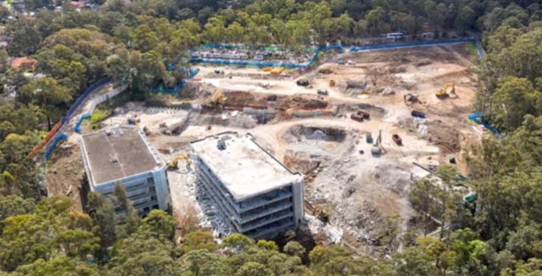
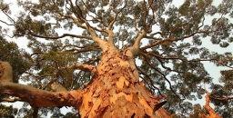
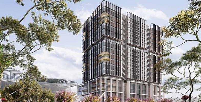
The Mirvac development of the former IBM business park at West Pennant Hills is proceeding. In September 2021 the application to demolish the existing buildings and remove 1,253 trees was approved. This has now been completed despite a lot of community concern about the disturbance to wildlife during the spring breeding season.
In October 2022 Mirvac’s Concept Development Applications for the next stage of the project came before the Sydney City Central Planning Panel. This involved the technicalities of subdividing the land into sections relating to the various types of building – 252 apartments and 165 medium density houses. Plus the removal of another 1,877 trees. There were many objections to the application for a height variation but the Hills Council had no objection to the apartment buildings being eight storeys instead of the LEP standard of six storeys.
So the concept DA has been approved. The only amendments to the conditions of consent related to protection of the Powerful Owls that have a nest site close to development footprint, use of wildlife friendly fencing and fauna sensitive lighting.
Forest in Danger found a big surprise in the documents submitted with the DAs. The future of the 10.3 ha of high quality forest containing critically endangered Blue Gum High Forest and Sydney Turpentine Ironbark Forest has been the subject of much controversy. The community believed they had a victory when Mirvac agreed to a Voluntary Planning Agreement dedicating the land to Forestry Corporation NSW so it could be managed as part of the Cumberland State Forest next door. This dedication of the land, defined as the Forest Dedication Land, was believed to be a condition of consent to be approved by the Panel.
Low and behold when the documents were submitted with the DA it was found that the Voluntary Planning Agreement dedicated ownership of the land to the minister for planning and would be only ‘managed’ by Forestry Corporation NSW. Not only that, Mirvac could request that the minister approve a change to the boundaries, and that the minister could approve or refuse the request at their absolute discretion and also request a change. So this land is no longer conserved in perpetuity. It appears that Mirvac can sell off some of the Forest Dedication Land. Forest in Danger has sent an objection.
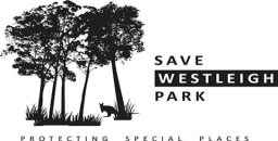
Save Westleigh Park – a new community alliance

I have to admit I didn’t know anything about the location of Westleigh until the Westleigh Park Master Plan development was announced by Hornsby Council. Westleigh is a small suburb on a ridge surrounded by Berowra Valley National Park and bushland along Waitara Creek and the biobanking site of Dog Pound Creek. The only road into Westleigh is Quarter Sessions Road with access via busy Duffy Avenue.
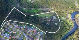
For the past two years Hornsby Council has been developing a plan for the development of the land known as Westleigh Park. This area of 36 ha was bought by council from Sydney Water in 2016. The water reservoir next to the park is still managed by Sydney Water. Currently council land has:
- a 26 ha area of bushland that is riddled with unauthorised mountain bike tracks – see STEP Matters Issue 217 for a story about what should be happening here
- a cleared area of 10 ha that was a land fill site and is predominately tufted grasses and unmaintained Kikuyu and weeds
- a Rural Fire Service building on the northern side so that land has been used for training
There has been community consultation and now it is expected that a final draft of the master plan will go before council soon.
The plan is for the creation of an extensive sporting field complex on the cleared land including three sporting fields, small areas for passive recreation and road access and parking areas. One of the fields may be synthetic which is inappropriate for an area so close to bushland. Preparation of the land for this development will be a major expensive exercise owing to contamination, its topography and need to control run-off into the nearby bushland.
Major traffic issue
One essential prerequisite for the creation of the park is improved road access. Council is expecting to get approval from Sydney Water to extend Sefton Road from Chilvers Road around the reservoir to Quarter Sessions Road. This will increase traffic significantly along Sefton Road through the industrial area of Thornleigh and the quiet suburban areas of Westleigh. A traffic study has forecast an extra 1,500 car movements a day at the Sefton and Chilvers Road intersection.
One possible solution for the problems the development will cause is to reduce the number of sporting fields and make the road only open for emergency access.
New alliance of community groups
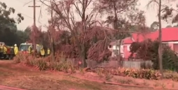
A group of ten local community groups (including Westleigh Progress Association, Friends of Berowra Valley, Protecting Your Suburban Environment and STEP) have formed a new alliance called Save Westleigh Park to keep both residents and businesses updated on council's current ill-planned schemes, as well as the significant impacts the development will have.
Council's community engagement with Westleigh residents has been poor. A recent council-run public meeting about the traffic impacts was only attended by 11 residents with seven apologies, as the meeting was by council invitation only. Yet obviously the traffic impacts are much wider than just those residents. Click here for the latest traffic study.
Action
Make your concerns about this proposed enormous regional sporting complex and its significant lasting impacts known through the traffic petition and the save Westleigh Park petition.
Eden Gardens office tower refused
Early in 2021 the owner of the Eden Gardens nursery complex on Lane Cove Road in Macquarie Park submitted a DA for an 18 storey office tower right on the edge of Lane Cove National Park. Ryde Council knocked back the application mainly for reasons of visual impact, traffic and height relative to surrounding areas.
The next stage would be a hearing before the North Sydney Planning Panel. In the meantime discussions were held with council and the panel trying to persuade the proponent to modify the plan to no avail.
The hearing was suddenly announced to be in December 2022. After all that time the applicant has not been able to obtain concurrence from the Rural Fire Service, Transport NSW and an Aboriginal Heritage Impacts Permit.
It was inevitable that the panel would refuse the application. Their determination summarised the situation that:
An acceptable redevelopment proposal of the site is more likely to be developed with close cooperation between the applicant and council. Such a dynamic has been lacking to date, as evidenced by the disagreements documented in the assessment report.
The next step will be a Land and Environment Court hearing in March. We hope the plans are considerably modified before that takes place.
A new owner for Naamaroo
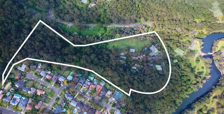
In November 2022 the Friends of Lane Cove National Park alerted us to the news that Naamaroo was on the market. This area of land, 6.2 ha, is next to Lane Cove National Park with an entrance in Lady Game Drive. It has been owned by the Uniting Church and has been used as a convention centre and children’s recreation camp.
Letters to the NPWS and the Uniting Church calling for the bushland (at least) to be added to the national park were dismissed. Given the interesting history of the site, it was very appropriate to add the site to the national park.
Tony Butteriss, President of Friends of Lane Cove National Park, undertook detailed research into the history of the site as documented in the December issue of their magazine Regenavitis.
In summary, the Naamaroo land was part of the Moore Estate that gifted 238 acres from the estate in 1938 to establish Lane Cove National Park. The trustees of the estate retained control over the land. Later part of this Moore Estate was gifted to the Congregational Church (now the Uniting Church). There is a record of sub-division and transfer made in 1961. This land became the Naamaroo property.
The property has been bought by The King’s School for $14 million.
The land is zoned as RE2 or private recreation, one of the objectives of which is to protect and enhance the natural environment for recreational purposes. While this zoning places an emphasis on caring for the environment there is scope for development. However we have been advised by Kings that the existing uses will continue and the property will be available for general community use as currently applies.
The letter from The King’s School states:
As a new member of the Lindfield community, we look forward to getting to know all interested locals and hearing what makes Naamaroo special to you. As a school acquiring the property from a church, there may be some differences in the way the site is operated, and we want to partner with the community to ensure any change minimises impacts to nearby residents and local road users.
There is little doubt that this area was once part of the national park and we hope that the bushland will be cared for in the same manner as a national park.
Manly Warringah War Memorial Park receives heritage listing but what will be the impact of the Beaches Link tunnel?
Manly Warringah War Memorial Park Is an area of 375 ha that covers the Manly Dam, its catchment area and the immediate bushland area below the dam. The Save Manly Dam Catchment Committee has worked for many years on looking after the bush in the catchment and restoring the Mermaid Pool below the dam that was a rubbish dump site.
Manly Dam was given heritage status because of the area's long history going back to the 1890s when the dam was built to be the major water source for Manly. The preservation of the dam's catchment is one of the reasons that we are so lucky to still have this amazing area of quality bushland that supports high biodiversity including many threatened species so close to the centre of Sydney. Areas like this are rare so that the highest possible level of protection should be applied.
The local community through the Save Manly Dam Catchment Committee has demonstrated their strong support for the area with many hours put into removing rubbish at the Mermaid Pool and volunteer bushcare works. It is an excellent site for citizen science projects.
The park has a long history of use by the Gayamaygal people, with evidence of engraving sites, and the bushland vegetation provided bush tucker and material for a huge range of tools like rope, fishing nets, medicine, shields and canoes.
Manly Dam is an example of rare concrete-walled gravity dam that pioneered wall strengthening methods and technology and was a world first for its time. It no longer provides its original use as a water supply and now is a valuable recreation area.
At the declaration ceremony the Environment Minister and local member, James Griffin, claimed that heritage listing will help protect this treasured area and its stories for generations of Sydneysiders to continue enjoying into the future. But will it?
Beaches link tunnel proposal
The Beaches Link tunnels proposal is a massively expensive road project that is yet to receive funding commitments. It will greatly encourage the use of private cars and goes against the NSW Government’s commitments to reduce carbon emissions.
This video demonstrates the damage that the project will do to the catchment of the Manly Dam caused by the widening of Wakehurst Parkway. Bushland and flying fox habitat along Burnt Creek will be destroyed.
This article in STEP Matters Issue 209 provides more information on the environmental damage the project will cause.
There has not been any serious consideration of alternatives such as improved bus lanes or a metro to Chatswood from the Northern Beaches Hospital.
Prospects for better fauna protection on development sites
In October, at NSW’s Local Government Annual Conference, a motion calling for better protection of wildlife on development sites was passed unanimously. The government now has to agree to implement standards to ensure that native wildlife found on development sites are given a chance of survival. We have standards for occupational health and safety, contamination and waste management so why not caring for wildlife?
Currently an approved Fauna Management Plan is required before a development can proceed but the quality can vary. The plan explains how wildlife that is found should be handled. They are dependent on the experience of the ecologist writing the report along with the developer expectations.
Poor plans are becoming more prevalent as there is more development of greenfield sites and densification of suburbs with canopy cover and flora and fauna corridors. Some plans even provide for injured animals to be euthanised on site. Often wildlife carers have to perform rescues as animals try to escape or are injured.
It all started at the Mirvac site in West Pennant Hills and the fact that they were removing thousands of trees but the planning documents had very few provisions made for protecting the wildlife living in them. There were no requirements to check whether nests, hollows or burrows were occupied and then relocate the birds, possums, echidnas or wombats. It’s the same across all development sites and yet wildlife carers have to follow very stringent codes of practice for any of their interactions with wildlife. Plus all native wildlife in NSW is protected by law – so the question asked by the local community was, where are these protections? And what is happening that they are not being applied?
The issue was raised by some local Hills Shire councillors but the proposal for a motion was defeated by the liberal-dominated council. So the group turned to Hornsby Council. After much discussion between many councillors, community members, journalists, vets, wildlife carers and a lot of persistence Hornsby Council councillors agreed to present this motion before the conference in August.
As Cr Salitra said in presenting her motion to Hornsby Council:
Legislating standards for wildlife on development sites will provide certainty for all stakeholders – the developer, ecologists, tradespeople, wildlife carers and our community. Certainty in procedure will provide clarity on who and what these standards apply to for all stakeholders in a currently grey area. And they will result in more efficiency on development sites, where these repeatable actions become the norm.
Why has it taken so long to implement these standards?
NPWS cycling strategy

In STEP Matters Issue 213 we commented in detail on the new draft NPWS cycling strategy. This is a highly controversial issue so many submissions were made.
The final documents have now been published and can be downloaded from the NPWS website. As the website states:
National parks managers will now have guidelines to improve sustainable cycling experiences and manage unauthorised tracks in consultation with stakeholders, while fulfilling legal requirements to protect our natural and cultural heritage.
Compared with the draft the final documents are much simplified. There is now greater emphasis on the need to protect the environment and prevent damage being done by unauthorised tracks. We hope there will be enough funding and staff resources to actively close down and rehabilitate these tracks that have proliferated in recent years. There is likely to be strong opposition from the mountain biking lobby so a determined level of enforcement will be required.
There are two documents:
- the actual strategy
- guidelines for implementation
Submissions were highly critical of a point scoring system in the draft guidelines that takes into account a multitude of criteria for deciding whether a proposed track route is suitable. This seems to be highly discretionary. The proof of its effectiveness will be revealed in time. However the important decision up front as to whether or not a new track should be built or unauthorised track approved is now more definitely defined and simplified.
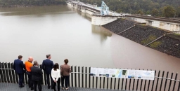
Warragamba Dam wall raising
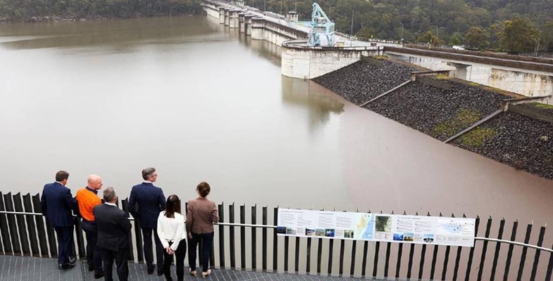
Nothing has been happening with the Warragamba Dam wall raising proposal for some time. The idea was first raised by Premier Michael Baird in June 2016. The cost is prohibitive and the EIS has been roundly criticised for lack of detailed analysis of the impact on indigenous sites and biodiversity. Also the EIS relies upon biodiversity and cultural surveys conducted before the unprecedented wildfires of 2019–20.
The federal environment minister still has to give the go-ahead to a project that will damage the World Heritage Blue Mountains. There is no funding contribution promise from the federal government or commitment from the NSW Government.
Yet the premier, Dominic Perrottet announced suddenly in October that the project is declared to be critical state significant infrastructure. This apparently will be an election winner for the Liberal Government in western Sydney even though flood modelling shows that it will not solve the problem of inundation of some suburbs as much of the water comes from rivers that enter the Hawkesbury Nepean system below the dam wall.
Critical state development means it can progress more quickly through approval processes and will be more difficult to oppose in the courts.
The NSW Department of Planning and Environment is now reviewing further community input on the proposal to raise Warragamba Dam wall, following the release of WaterNSW’s response to submissions and a preferred infrastructure report. The response dismissed most of the concerns raised in the 2,500 submissions. It even opens the possibility for changing the World Heritage area boundaries, in an attempt to avoid Australia’s international obligations.
The report reveals that health officials mirrored the concerns of Sydney Water, saying they had:
…concerns for drinking water quality during the construction and operation of the flood mitigation works proposed.
The extra water held behind the raised dam wall was: ‘likely to affect water quality’ in the dam during periods of flooding because of ‘increasing turbidity, colour and organic material’ from new parts of the catchment.
Wildlife trapping netting banned in Victoria; NSW next please?

Victoria has legislated to enable backyard fruit growers who use the wrong netting and those who sell or advertise it, to be fined. The fine for using fruit netting that doesn't meet the new specifications will be $3,303 and also a fine of $660 will apply to anyone advertising the illegal netting or offering it for sale.
During the 2021–22 summer Wildlife Victoria found nearly 300 cases of wildlife caught and injured in domestic fruit tree netting. That ranged from flying foxes, which were the majority of cases, magpies, rainbow lorikeets, sulphur-crested cockatoos and possums. They suspect the numbers could be a lot higher as, in a lot of cases, the animals are already deceased or they may be unreported.
Domestic fruit growers will be required to use netting with an aperture of 5 × 5 mm at full stretch. A finger can’t get into that size.
Please contact your local MP or the NSW Agriculture Minister, Dugald Saunders, to request that the same legislation be enacted in NSW.
Norman Griffiths synthetic turf

We are still waiting for the review of environment factors for Ku-ring-gai Council’s project to install synthetic turf at Norman Griffiths Oval in West Pymble. See STEP Matters Issue 217 for more background. It is over a year now since council decided to proceed with the project.
We understand that council is waiting for the Chief Scientist’s report on guidelines for the use of synthetic turf to be released. That, we understand, was completed in August and is still sitting on the planning minister’s desk, probably until after the election. What has he got to hide?
On the subject of synthetic turf, the Natural Turf Alliance has a new website with lots of information about synthetic turf and the alternative of natural grass.
The Natural Turf Alliance is a registered association consisting of community groups, including STEP, committed to preserving and developing natural grass open spaces including sporting fields.
Byles Creek land zoning change approved by council

As reported in STEP Matters Issue 216 Hornsby Council voted in favour of changing the zoning and other conditions in the LEP in relation to land in the Byles Creek Valley.
This decision has now been translated into a planning proposal that has been agreed by the mayor and councillors to go to the state government for their approval.
Once approved by the government, this proposal will allow changes to the R2-zoned land to more environmentally sensitive C4 zoning. This will prevent any further subdivision of the large lots in the subject area with associated wholesale clearing to provide asset protection zones. There will be greater protection of the riparian zone which is the land adjacent to the watercourse, in most places 30 m wide on each side of the creek.
Four years ago members of the Byles Creek Valley Union were told by their local member, Dominic Perrottet, that funds were in place to acquire some of the privately held bushland and he promised that he would take steps to start the process. Despite several follow ups this promise is still to be actioned.
Plan to establish a UNESCO georegion in northern Sydney

The Friends of Ku-ring-gai Environment (FOKE) has initiated a fascinating project aiming to gain aspiring georegion status for the Ku-ring-gai region.
UNESCO global geoparks are single, unified geographical areas where sites and landscapes of international geological significance are managed with a holistic concept of protection, education and sustainable development. The Ku-ring-gai region is well known for its significant natural and cultural heritage values. The georegion would cover the national parks as well as the coastal cliffs and lagoons. An integral part of a georegion is the development of geotourism projects such as educational trails focussing on the geology and landscape.
FOKE has support from local councils, the National Parks and Wildlife Service, community groups and politicians. They have had significant support from the Australian Geoscience Council and the Linnean Society of NSW.
Linnean Society Symposium
The northeastern Sydney Basin is bounded by Sydney Harbour to the south, the Hunter River to the north, the coastline to the east, and the boundary of Yengo National Park to the west. Much of this area lies within the distinctive lower Triassic Sydney Sandstone outcrop with its spectacular geomorphology and characteristic floral communities.
At the symposium, 16 papers were presented on current research into the geology and geodiversity, flora, fauna and Aboriginal occupation of the region. The afternoon session promoted the concept of a Ku-ring-gai GeoRegion (click here to buy a copy of these papers).
Stephen Gale spoke on the origin of the Hawkesbury River and its varying paths; Wendy Grimm explained her research into the endangered lesser-known terrestrial orchid Genoplesium baueri; Michael Gillings and Vanessa McPherson presented their findings on local fungi (a welcome reminder of their talk to STEP last year); Jonathan Sanders gave clues to the vegetation you might find around local volcanic dykes; Doug Benson’s subject was the last glacial maximum and its effects on our plants; and Chris Mays’ group looked at mass extinctions in an end-Permian event and the causative role of climate change.
The Ku-ring-gai GeoRegion project aims to unify the much-loved values of Sydney’s northern natural areas through geosites and geotrails. The project includes Ku-ring-gai Chase National Park, the Northern Beaches coastline, Muogamarra Nature Reserve and the eastern section of the Berowra Valley National Park.
John Martyn, eminent geologist and STEP committee member, spoke of the unique geological formations; Ian Percival spoke on the Hornsby Diatreme whose western face he has worked hard to preserve for the public; John Illingsworth and Peter Mitchell showed how drones can help produce 3D photogrammetric models and digital elevation models, that is to say, fantastic pictures of the Northern Beaches cliffs!
Jayden Walsh described the varied fauna; Bob Conroy related Aboriginal sites to landscape features; David Robson noted benefits to tourism; Angus Robinson concluded the day broadening our local project within an Australia-wide movement: in 2021 the Australian Geoscience Council launched its National Geotourism Strategy. Its aim is to enrich nature-based tourism, the main motivator for travel to Australia, embracing the ABC of tourism: abiotic landscapes and geology, biotic flora and fauna and cultural Aboriginal history.
The symposium was ideal for participants with an interest in the area but not necessarily scientific training. The Linnean Society of NSW has done an excellent job with the symposium and the field day visiting our scenic wonders.
Since 2010 the Linnean Society NSW has been organising field symposia highlighting aspects of natural history. In November 2022 they hosted a symposium entitled Natural History of the Northeastern Sydney Basin. Thanks to Margery Street for this summary.
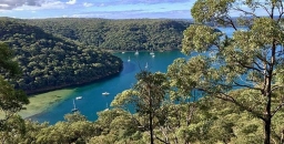
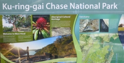
Ku-ring-gai Chase National Park draft plan of management
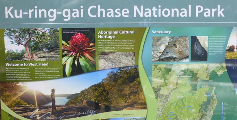
KCNP’s current plan of management is over 20 years old and its review is moving at a glacial pace. In August 2019 a series of discussion papers were released for public comment and ideas. It took until January 2022 for a summary of these submissions to be published. Then, finally, a new draft plan of management was open for submissions up until November 2022.
The plan needs to be updated to allow for the large increase in usage of the park and waterways and demand for facilities such as car parks, tracks and trails. Then there is climate change.
Nor does the plan mention the work being undertaken advocating for KCNP to be declared a UNESCO georegion. Success with this project will enhance international recognition and tourism potential of the high quality landscapes of the parks. A detailed plan of management is prerequisite for a successful nomination.
The main issue with the plan of management is that there is no plan; there are suggestions for adaptive reuse, precinct plans to come, proposed strategies, tourism initiatives and memoranda of understandings but few concrete proposals and timeframes on which to comment. It is mostly business as usual.
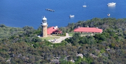
Barrenjoey lighthouse precinct

The future of Barrenjoey lighthouse has long been a bone of contention. The submission summary reported that adaptive re-use of heritage buildings at Barrenjoey Head is supported by some but not for short-term accommodation or other commercial purposes.
Nevertheless the government has just announced a proposal for Airbnb or short- term accommodation at the cottages on the headland. Turning these cottages into holiday rentals would not occur before 2025 following heritage and planning approvals, upgrade works and community consultation. This has sparked strong local community opposition. Time will tell what the outcome will be.
Successful habitat also includes darkness
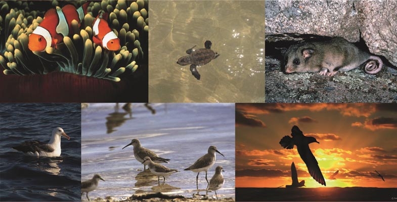
In 2018 the Powerful Owl Coalition highlighted the importance of reducing artificial lights near bushland in the publication Protecting Powerful Owls in Urban Areas. They recommended avoiding public lighting that illuminated the full height of trees as this would impact both Powerful Owls and their prey and keeping lighting, particularly bright artificial sports lighting, away from riparian areas, other core habitat and nesting sites.
Since then, the Powerful Owl Coalition, STEP, Byles Creek Valley Union, PYSE Inc and the Powerful Owl Project of Birdlife Australia have been writing to Hornsby Council and other authorities about the importance of darkness for fauna, both nocturnal and diurnal as the ratio of light to darkness helps regulate many aspects of wellbeing for fauna.
Indeed, the effects of artificial light at night can be so profound that it can change reproduction, feeding, sleep, and protection from predators to the degree that apparent habitat cannot be used by some fauna species.
Since 2018 most of our submissions addressed artificial light proposals for Hornsby Park (the Quarry) and Westleigh Park as the proposals for increased use of these sites would include night lighting. Both these sites include known populations of Powerful Owls which have a conservation status in NSW of vulnerable to extinction.
In December 2022 the Powerful Owl Coalition wrote to Hornsby Council about the Beecroft to Cheltenham Bike Track, a track that passes through an area famed for its Powerful Owl population. As a result, council contacted the Powerful Owl Project and discussed these matters further with their co-ordinator.
As a result of the submission and these discussions, the Powerful Owl Coalition received a prompt reply from council. They were overjoyed. Huge steps have been made for the protection of wildlife, not just Powerful Owls, by the proposed lighting for the bike track and in the revised Australian Standard AS4282.
The specifications for lighting the Beecroft to Cheltenham Bike Track align well with the National Light Pollution Guidelines for Wildlife Including Marine Turtles, Seabirds and Migratory Shorebirds (Australian Government, 2020).
Further comments from council’s reply are given below:
The Coalition may be interested to know that our lighting consultant actually sits on the AS4282 committee as a co-opted expert and that the new revision of the standard (which should be coming out next year) includes spill lighting limits for Environmentally Sensitive Areas which includes ‘naturally dark areas including bushland, waterways, marine and coastal areas’.
The new standard will consider the impacts of spill lighting on plants, wildlife and ecosystems by applying limits when previously there were none. To the best of our consultant’s knowledge this is the first normative obtrusive lighting standard in the world to consider the impact upon biota.
Hopefully this should give the Coalition some comfort that the numerous stakeholders on the committee (formed by government, industry and lighting experts) are taking the matter of protecting our unique night time habitats seriously.
Suffice to say I am advised that council’s consultant has taken every effort to minimise light spill beyond the target area and into the canopy and that they ‘strongly believe in protecting the night time environment and [their] approach is to use best practice design to minimise light pollution/spill whilst still achieving the objectives of the project.
The Powerful Owl Coalition thank Hornsby Council for engaging such a knowledgeable and forward thinking consultant, for caring about the fauna of the ‘bushland shire’ and for using these standards before publication.
We look forward to these standards being applied in Hornsby and Ku-ring-gai, particularly in developments in and adjacent to bushland such as Hornsby and Westleigh Parks and Norman Griffiths Oval.