Displaying items by tag: housing
Ku-ring-gai Council’s TOD development alternatives

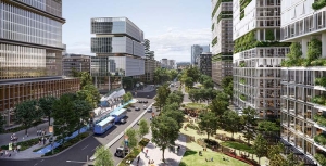
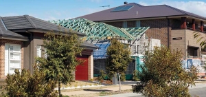
The NSW government announced new planning laws in late-2023 that will radically change the landscape by increasing housing density at the expense of tree canopy, heritage design and landscape character. The changes are focussed on locations near to public transport with development of low to mid-rise housing within 800 m of stations and local centres.
In addition, Ku-ring-gai has been identified as a location for more intense development near Gordon, Killara, Lindfield and Roseville stations defined as Transport Oriented Development or TOD for short. This imposes 6 storeys within 400 m of the stations regardless of current zoning, with greater heights of 7 or 8 storeys if affordable dwellings are included. In the town centre zones slightly higher flats are proposed of 7 to 9 storeys.
Council has been fighting against the imposition of these changes by taking legal action in the Land and Environment Court. The detail of this action is confidential.
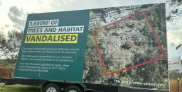
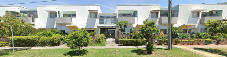
The whole community is concerned about the legislation. These station areas contain prime examples of outstanding heritage architecture in wide tree-lined streets. Council has estimated that, if the proposals were to be fully implemented, over 400 properties in heritage conservation areas would be demolished plus another 136 properties would be next door to the TOD areas and would be negatively impacted.
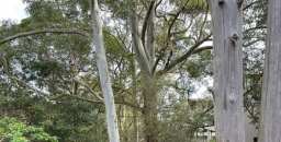
Streetscapes and tree canopy cover would be lost because the policy does not provide for the essential space for tree survival such as minimum lot size, deep soil, adequate setbacks and minimum planting.
Alternative scenarios
Council has been examining alternative scenarios that could deliver a similar number of new dwellings to the government objectives but protect heritage conservation areas and change the planning parameters for construction so that tree canopy is protected. Of course there will have to be trade-offs.
Not only are the defined parameters bad for the character of the TOD areas but also council believes that they will not be attractive for developers to build so the government’s objectives will not be met. This applies in particular to construction in town centres where there are constraints caused by existing configurations. Council believes that shifting more of the extra dwellings into town centres via mixed commercial/residential buildings will be more financially viable for developers.
This highlights the situation that the ball is still in the court of developers to make things happen. There is no direct government investment in new housing projects.
Consultation
Council has analysed five possible scenarios that are consistent with the government’s estimates of 22,580 new dwellings within 15 years. The scenarios actually produce slightly higher estimates of 23,200.
The agenda papers from council’s meeting on 30 October provide a detailed description of the analysis that has been undertaken.
We have been asked to make submissions expressing views on these scenarios by 17 December. You can also complete a survey.
Council will consider community feedback in February 2025. If there is support for a preferred scenario council may ask for the government’s approval to exhibit it as a replacement for the government’s policy. The exhibition will be a further opportunity for the public to comment.
Consideration of constraints
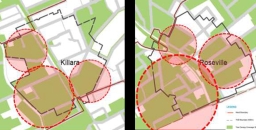
The TOD SEPP applies blanket changes to planning rules within 400 m of Gordon, Killara, Lindfield and Roseville stations.
Council has examined the areas in detail to consider topography, existing development and financial feasibility. All these factors have been ignored in the state government’s simplistic one-size-fits-all changes. They have applied some basic principles to the analysis to select locations suited for the changes in planning rules, such as:
- to avoid environmentally sensitive areas and tree loss
- to minimise heritage impacts
- to manage transition from high rise to low density so that houses are not squeezed between high rise flats
- to revitalise town centres
An example of the difference between the TOD high rise parameters for residential buildings and the current council development control plan on a typical site of 2,000 m2 is:
- TOD requires 1 to 2 medium trees
- council development control plan would require 6 to 7 large trees
The current tree canopy cover averages 34% in the TOD areas. This could be wiped out if the full redevelopment occurred.
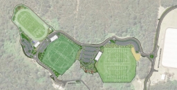
The red circles in the map at the top of the page indicate where the TOD applies to areas with tree canopy cover over 30% in in Killara and Roseville.
Council’s five scenarios
Scenario 1
Based on the NSW government's existing TOD policy which zones areas within a 400 m radius of stations for 6 to 8 storey development with minimal protection for heritage or environmental areas.
Scenario 2a
Protects 78% of heritage neighbourhoods and allows building up to 25 storeys in town centres.
Scenario 2b
A minor amendment to the NSW government’s TOD policy, which protects 31% of heritage areas and allows buildings up to 15 storeys in town centres.
Scenario 3a
Preserves all heritage areas and delivers a high level of tree protection. However, it means very tall buildings in town centres - up to 45 storeys in Gordon.
Scenario 3b
Also preserves all heritage areas but to limit building heights in town centres to a maximum of 20 storeys, the apartment buildings are spread further from stations.
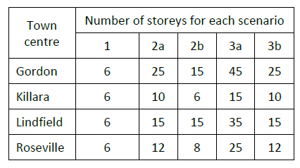 Trade-off
The major trade-off is in the town centres. The preservation of canopy and heritage comes at the cost of high-rise development in the town centres as shown in the table.
For comparison, note that the maximum height in Hornsby near the railway line will be 40 storeys.
There is more to come – dual occupancy
Council’s December meeting papers introduce detailed discussion of the next issue for increased housing density. That is the definition of minimum lot size where dual occupancy can be imposed in low density residential areas. The original announcement was that dual occupancy could be built in all low density residential areas with a minimum lot size of only 450 m2.
The government has accepted that this development is unsuitable for some locations for bushfire risk, heritage and environmental reasons. Three options for minimum lot size definition is presented in this report for council's consideration. After discussion with the Department of Planning the options will be presented for public consultation in early-2025.
What about the longer term?
One issue that has not been considered is what happens beyond the projection period of 15 years. Sydney’s population is going to keep growing. The ABS’s latest forecast is for the NSW population to grow by another 2 million between 2041 and 2071 having grown by 1.6 million over the 15 years to 2041 that the housing plans are aiming to cater for.
Confusing messages on NSW government TOD proposals

The NSW government’s Transport Oriented Development (TOD) plans came into effect on 1 April. We provided an outline in the previous issue of STEP Matters. Ku-ring-gai Council has been trying to negotiate a softening of the impositions imposed by the plans with little success. Basically, the TOD means that 6 to 7 storey flat buildings can be built in all residential zones within 400 m of the Gordon, Killara, Lindfield and Roseville stations or 8 or 9 storeys if an affordable housing component is included.
Council has been trying to negotiate with the Minister for Planning, Paul Scully, and the Department of Planning to reduce the impacts, particularly on heritage conservation areas and tree canopy. The specifications for the building size (floor space ratio of 3 to 1) and minimum land area mean that here is no room for any trees in addition to the building footprint.
Council has argued that they need 12 to 18 months to plan a housing strategy properly and in accordance with guidelines from the department – a 6 month extension has been offered. Ideally planning should also encompass the other part of the announced changes to provide for low to mid-rise housing within 800 m of all railway stations and St Ives centre. An idea of the target for new housing numbers would also be a help.
Council also tried to take one of the TOD stations, such as Killara, off the list and shift the numbers to the other TOD stations. The 400 m radius around Killara is the area with the greatest proportion of heritage houses and it doesn’t have any shops.
Paul Scully would not consider any of these arguments. So there is now a stalemate.
The current situation is that the TOD State Environmental Planning Policy (SEPP) is being imposed on Gordon, Killara, Lindfield and Roseville from 1 April. Council has still not received a copy of the document (the SEPP) that acts as the regulation of the planning rules that are supposed to guide the implementation of the policy.
Meanwhile the developers are ready to pounce from the middle of May.
The low to mid-rise housing changes are due to come into effect later this year. Targets are yet to be revealed although the 42-page Explanation of Intended Effect provides sufficient detail to conservatively anticipate the doubling of Ku-ring-gai’s population as a combination of both the TOD and low to mid-rise housing SEPPs.
The standoff continues on the major issues with the TOD plans:
1. Heritage conservation areas
There are still conflicting statements being made about the application of the new housing to heritage conservation areas. The government has stated in the media that current council heritage provisions under the LEP and DCP can continue to apply. Demolition would not be permitted of heritage buildings or those that contribute to the heritage value of the conservation area. They optimistically state that there will be opportunities to build new housing consistent with the heritage values of the TOD area. How can that be possible in an area like Killara with 80% of the TOD area being heritage conservation areas?
Many high rise buildings will be required to achieve the target of at least 4,500 to 5,000 new homes over the next 15 years in each TOD area. The minister states that council will still be the consent authority and will be able to conduct merit assessments of development applications. But these assessments will have to comply with the new standards that conflict with the Ku-ring-gai DCP specifications. It doesn’t make sense!
2. Traffic
The mayor’s concerns about local traffic are dismissed. The minister seems to think that the railway line is all that is needed. What about all the people that need to travel to the north along Mona Vale Road or Warringah Road and to the south via Lane Cove Road or Mowbray Road? They have to use the already highly congested Pacific Highway to get to these roads that are located some distance away from the TOD stations.
3. Local services
As the mayor points out in his letter, the people living in all these new dwellings require amenities such as parks, libraries and community spaces. It is unlikely that developers will include space for health and education needs. So, the council has to cover the cost but the government has not offered any funding. The council had almost finalised plans for the Lindfield Village Hub when the government withdrew its agreed contribution.
There are various development contribution schemes but no certainty about how the money raised will be distributed.
Land values have already increased markedly since the new housing plans were announced making it more difficult for council to buy land to be used for new amenities.
4. Tree canopy
State and all local governments are proceeding with tree planting activities in the hope of achieving the target of 40% urban canopy by next decade. Ku-ring-gai is trying to better this target. However the TOD mid-rise housing specifications leave no room for trees. The low to mid-rise housing specifications require only 15 to 20% deep soil space so the 40% target would not be achievable.
There will be no room for trees unless there is room on the nature strip but with all the disturbance from construction of these buildings and their underground car parks trees of any size large enough to provide shade are unlikely to survive.
The Urban Forest Strategy points out that 70% of urban trees are on private land. Council has limited capacity to increase tree cover to meet the target and the housing proposals make this even harder or impossible.
Upper House enquiry
The Legislative Council initiated an enquiry into the TOD proposals that is due to report by 27 September. This has called for submissions on the investigations and consultations prior to the TOD announcement into the appropriateness of the chosen locations and the impacts on heritage, capacity of infrastructure and on local amenity and environment.
There are already over 180 submissions on their website pointing out problems with the proposals. The committee has a big job on their hands to distil these submissions. How much notice will the government take?
Government plans to increase housing density are roundly condemned
In December, just as we were looking forward to a peaceful holiday break, the NSW government released plans for new policies aimed at increasing housing density to cater for the massive increase in demand brought about by recent and projected high levels of immigration. We all understand the need to boost housing supply in the right areas to avoid adding to the existing suburban sprawl but the way the government is going about it is totally unacceptable.
The explanatory document, the Explanation of Intended Effects: Changes to Create Low- and Mid-rise Housing (the EIE), makes some grandiose statements. It claims that:
The changes will give NSW households more choice and promote vibrant, sustainable and liveable communities …. Our longer term aim is to enable better planning that is led locally.
This all plain spin.
The reality is that a new planning system is being imposed without opportunities for local input. Council local environment plans (LEPs) and controls will be overridden by ‘non-refusal standards’ determined on a one-size-fits-all basis.
The headline description of the new housing typology is that they will be well-located and well-designed. However, the standards in most of the redevelopments will create housing that leaves only room for a small or medium size tree in a small garden. Existing mature tree canopy will be severely reduced so all the government rhetoric about creating ‘liveable’ communities in the face of climate change will become meaningless. These mature trees and their environmental benefits cannot be replaced.
The EIE applies to the Six Cities Region that covers the Illawarra, Blue Mountains, Sydney and Newcastle and lower Hunter with the exception of dual occupancy provisions that apply to the whole state.
Transport Oriented Development (TOD)
Another announcement was made in December that has potentially drastic implications for the established suburbs of Gordon, Killara, Lindfield and Roseville. No consultation with the public is to occur and Ku-ring-gai Council has had limited opportunity to have their say to the Department of Planning. This development standard is to be implemented from 1 April. More detail is further on in this article.
When will this all happen?
First of all the government has to finalise the new State Environment Planning Policy (SEPP) that governs the implementation of the policy. The intended effective date is mid-2024. So time is tight.
The government did invite feedback from the public, councils and stakeholder bodies. This is currently being considered and a response will be published. Whether they will modify the policy to recognise the outpouring of criticism remains to be seen.
The intention is to ‘fast-track’ the new housing plans so it is likely that the problematic complying development process with private certifiers will be used. In 2022 only 48,000 new homes were completed in NSW. The goal of this new policy is to build 75,000 new homes over each of the next 5 years in accordance with the new housing accord agreed between the states and federal governments.
How will it happen?
That is the big question that will determine whether the intended large increase in the number of dwellings does actually occur. It appears that developers will be knocking on doors with generous offers to buy people’s houses. Alternatively landowners will put their place on the market. The take-up response is unknown so the outcome is unpredictable.
The normal process is for councils to be given new housing targets over a wide time frame and they then carry out strategic analysis and community consultation to identify where the increases should occur by rezoning areas for higher density housing development. Controls are defined taking into account local conditions such as existing infrastructure, topography, local character and heritage, biodiversity protection and bushfire risk. They aim to avoid issues like overshadowing and increased stormwater flood risk. This provides certainty for all parties that enabled long-term planning.
Non-refusal standards
This time the state government proposes new ‘non-refusal’ standards – if types of development are compliant with such a standard, they cannot be refused. As these are to be implemented under a SEPP, they can overrule LEPs or Development Control Plans. These standards are outlined in the EIE.
In recent budget estimates hearings the Minister for Planning claimed that councils will retain their powers to control development. Yes okay, but only if the council controls are similar to or more permissive than the non-refusal standards in terms of the housing outcomes. This is obviously unlikely.
The implementation of the EIE is undermining the government’s own existing statutory strategic planning framework that coordinates new housing plans. The government is working on new regional and district plans to be released in 2024 that should inform local council plans. In June 2023 the government abolished the Greater Cities Commission that had the role of determining these plans. This function has been brought back to the Department of Planning. So currently we do not have a holistic plan allocating when and where the increased housing numbers should go together with the associated infrastructure needs.
Higher density standards
There are three types of higher density housing that are to be implemented:
- dual occupancy in R2 (low density) residential areas
- low-rise housing in R2 zones within 800 m of railway stations and local centres
- mid-rise housing in R3 (medium density) zones within 400 m of railway stations and local centres
1. Dual occupancy in all low density (R2) zones in the whole of NSW
This change may have the most significant impact in the character of our cities and towns. Currently many councils do not allow dual occupancy in R2 zones. This includes Hornsby and Ku-ring-gai. If this option is taken up by many landowners then the tree canopy cover of all our suburban areas will reduce significantly.
Under the non-refusal standards, any block that is at least 450 m2 could be converted to dual occupancy. Another house can be added to the existing one on the block or an existing house can be knocked down and replaced with two houses. Larger blocks that are common in northern Sydney of over 900 m2could be sub-divided into two blocks and then two dual occupancies could be built – four houses in all. Currently the local trend is to knock down established houses and replace them with a much bigger single house. Will this trend continue as well?
In either case established tall trees and gardens are being cleared and replaced with smaller trees and hedges that will be of limited value for cooling the environment and providing habitat for wildlife. The EIE prescribes a minimum number of trees be planted depending on the size of the block but they only need to be a small tree (5 to 8 m – bottlebrush size) for a medium size block and medium tree (8 to 12 m – jacaranda size) for a larger block of over 600 m2.
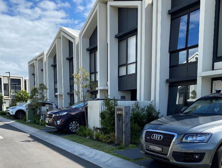
2. Low-rise housing close to local centres
Low-rise housing as defined in the EIE is to be permitted in R2 zones within 800 m of railway stations and local centres (zoned E1). The definition of local centre is up for discussion. It is intended to apply to places with a good range of services such as a full-sized supermarket and restaurants. In our area it would apply to St Ives. It is also intended to apply to centres with good access to public transport. St Ives has poor public transport and frequent traffic congestion.
Low-rise housing will include:
- manor houses – two-storey flat building – can be four or more flats depending on land area
- terraces – row of dwellings
- townhouses or villas – multi dwelling housing
Manor houses
Terrace
The specifications for maximum floor space ratio and minimum site area will mean that the space remaining for gardens and trees will be very limited. The minimum tree canopy target for larger blocks is 30% assuming the trees will reach maturity compared with the current guideline of 40%.
The greater density will increase the need for car access. This means more driveways with less space for street trees.
It appears that sub-division will be encouraged so that the normal sized lot in the northern Sydney area could be sub-divided and replaced with two or three low-rise developments.
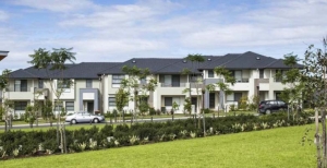
3. Mid-rise housing
Mid-rise housing is to be permitted in E1 (local centres) and R3 (medium density) zones within 800 m of railway stations and local centres. This is defined at residential flat buildings or shop-top housing. The maximum height allows for building up to six to seven storeys (maximum height 21 m) within 400 m of the station or town centre and up to four to five storeys (maximum height 16 m) in the 400 to 800 m radius.
Developers can add extra floor space if affordable housing is included. If 10 to 15% of the gross floor area is allocated to affordable housing then the height can be increased by 20 to 30% respectively. This means a six to seven storey building can be increased to eight to nine storeys.
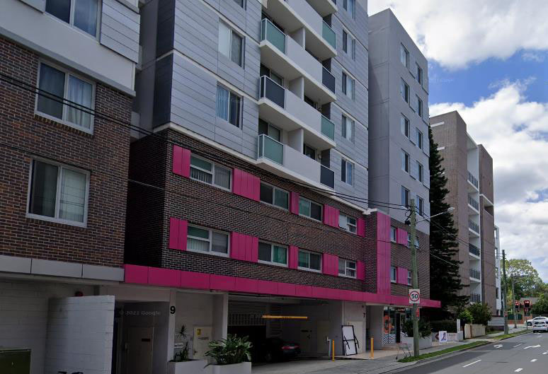
Mid-rise housing
Transport oriented development
Four station areas, Gordon, Killara, Lindfield and Roseville have been identified as places appropriate for Transport Oriented Development (TOD); 31 areas in total have been identified for the TOD in the Six Cities Region. This Imposes mid-rise housing (six to seven storeys) within 400 m of these stations to be applied to all residential areas. Some of these areas already have higher rise development but the majority of areas are low density. Not only that, but 40% of these areas have a concentration of heritage housing.
The minister claims that the non-refusal standards can be avoided if Ku-ring-gai Council does their own strategic assessment and works out planning controls that will enable the new housing numbers to be accommodated before the TOD requirements are implemented. But they come into effect on 1 April and the government advice on the expectation of new dwellings has not been provided.
The government proposals have been roundly condemned
There is a long list of problems with the government’s denser housing proposals. Ku-ring-gai Council’s website contains their lengthy detailed submissions. On 3 February an extraordinary meeting passed a resolution that:
- Condemns the State Government for its irresponsible approach to planning for the future of the built and natural environment in
- Rejects the proposed changes to planning controls and demands that they be withdrawn with genuine consultation to be undertaken with councils and their communities, as intended by the National Housing Accord 2022.
Brief summary of issues
The proposals basically do not conform with the Environment Planning and Assessment Act and the principles of ecologically sustainable development.
Ku-ring-gai Council’s analysis of the higher-density development configurations for mid-rise housing shows do not even conform with the government’s own SEPP 65 Design Quality of Residential Apartment Development.
Government claims that there will continue to be opportunity for genuine merit assessment of developments, taking into account local character, biodiversity and heritage matters are meaningless. As currently announced the two SEPPs will apply a top-down one-size-fits-all approach.
The landscaping and building parameters prescribed in the non-refusal standards are not suitable for established suburbs. The planning system must continue to allow the consideration of issues such as consistency with existing built form, tree canopy targets, topography, bushfire risk with the need for asset protection zones and stormwater management.
As announced, development types will be determined by the developer resulting in a mishmash of housing styles throughout Sydney particularly in the areas near stations and local centres.
The mid-rise development of up to seven storeys near railway stations along the Pacific Highway from Roseville through to Wahroonga is very concerning. This will create a wide strip of development about 1 km wide that will be a barrier for wildlife movement between north to south bushland. The land falls away sharply on the southern side of the highway where the impact of the ridge barrier will be emphasised. These areas retain the seedbank and soils that are essential for the survival of the last remaining areas of remnant critically endangered forests.
Councils must be able to limit the amount of clearing on properties when additional dwellings are added so that mature trees are retained. The blanket dual occupancy approval provisions must not proceed.
The two proposals for ‘transport-oriented development’ and ‘low and mid-rise housing’ together endanger more than 4,000 heritage properties (items and sites within heritage conservation areas).
Response to housing shortage – will it trash liveability?
High net immigration is putting huge pressure on governments to get more housing built. But do we need to do this at the expense of planning rules that are intended to create housing areas where people might actually enjoy living?
The new NSW government has announced that it will scrap local council and planning panel processes for developments worth more than $75m if they include at least 15% affordable housing. Developers will be able to go straight to the Department of Planning via state significant development rules so that decisions will made more quickly.
Further, these developments will also gain access to a 30% floor space ratio boost, and a height bonus of 30% above local environment plans.
Councils have been assured by the Minister for Planning (Paul Scully) that they will be consulted about the strategic merit of these proposals and council local environment plans will not be overridden.
The reforms are set to take effect later this year and are a part of the government’s commitment to construct 314,000 homes over five years.
Huge growth in population over 2022
It is not hard to see why we need so much new housing. Australia’s population grew by almost half a million during 2022 to reach 26,268,000 people at 31 December 2022. The annual growth was 496,800 people (1.9%). Annual natural increase was 109,800 and net overseas migration was 387,000.
Medium Density Housing Code Implemented with some Improvements
The NSW government has finalised the Low Rise Medium Density Housing Code and Design Guide that were the subject of consultation during 2016. This code allows one and two storey dual occupancies, manor houses and terraces to be built using the complying development approval pathway. Unless the type of development is not permitted in a residential zone under a council’s Local Environment Plan (LEP) a single dwelling can be redeveloped into 2, 3 or 4 dwellings depending on the size of the block. Design guidelines will have to be met but councils will not have control on the rate of take up of this opportunity.
The code is due to take effect in July but local concerns about congestion and over-development have become so great that the government was forced to defer implementation in four council areas. The deferral is only for a year however. This applies to Ryde, Lane Cove, Canterbury Bankstown and Northern Beaches but other councils are also asking for a deferral. Many areas of Sydney are struggling to cope with recent heavy development and infrastructure is inadequate. Is the one year deferral enough time to catch up?
Some councils, like Ku-ring-gai, already have provisions in their LEP that prevent this type of development in low density residential zones. Other councils want (and need) to be able to control the location of this infill housing option and are still working on a housing strategy that would define where this new category of development could occur. These are the councils that are asking for a deferral. They have just woken up to the potential consequences.
STEP’s submissions on this new type of complying development criticised the ad hoc nature of the application of the code and the broad implications of converting low density into higher density housing. There could be a huge rush of landowners taking up the opportunity to expand the value of their property. Councils need to able to specify areas where this type of development is not suitable, for example, because it does not fit in with the topography or character of particular areas or there is insufficient transport. At least the NSW government has recognised that councils need more control.
Design Guide Improvements
The Design Guide has been developed in partnership with the Government Architect’s Office, and aims to improve design by addressing layout, landscaping, private open space, light, natural ventilation and privacy.
The Design Guide has been improved by defining minimum standards for greenery on the blocks. The government has finally taken on board the importance of trees and gardens in reducing the heat island effect and improving local amenity. The guide specifies:
- minimum landscaped areas
- retention of trees especially along a boundary except where removal is approved by council
- planting of a tree in the front yard if the street setback is 3 m or more (mature height 5 m) and in the back yard (mature height 8 m)
- minimum soil volume to support the trees
- an ongoing maintenance plan
The ongoing question will be how that can these guidelines be enforced and the gardens kept alive. Councils will have a big responsibility perhaps?
District Plans
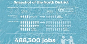
Have your say on the North District Plan and the Greater Sydney Strategy by 31 March 2017.
District Plans cover the plan for growing Greater Sydney in detail. Sydney is divided into six districts and ours is the North District.
Increase in Number of Dwellings
The table below summarises the implied new dwelling requirements from the population growth rates adopted in the Greater Sydney Strategy.
| Council | Existing 2011 | 2011–16 | 2016–21 | 2021–26 | 2026–31 | 2031–36 | Change 2011–36 | % change 25 years |
| Lane Cove | 13,900 | 1,650 | 1,350 | 1,250 | 1,900 | 1,900 | 8,050 | 58% |
| Ryde | 44,050 | 4,950 | 6,250 | 5,650 | 5,100 | 5,000 | 26,950 | 61% |
| Hunters Hill | 5,400 | 350 | 150 | 150 | 200 | 250 | 1,100 | 20% |
| Northern Beaches | 103,800 | 4,950 | 2,900 | 4,050 | 5,100 | 5,400 | 22,400 | 22% |
| Mosman | 13,750 | 550 | 300 | 250 | 350 | 400 | 1,850 | 13% |
| North Sydney | 37,000 | 2,950 | 2,750 | 2,700 | 3,100 | 2,900 | 14,400 | 39% |
| Willoughby | 29,050 | 1,900 | 1,200 | 1,400 | 1,850 | 2,000 | 8,350 | 29% |
| Ku-ring-gai | 41,050 | 3,150 | 2,750 | 2,850 | 3,300 | 3,250 | 15,300 | 37% |
| Hornsby | n/a as boundaries have changed | |||||||
Here is an example of how the increase in dwelling numbers could come from replacement of existing houses with higher density dwellings. If the average replacement ratio is three new dwellings for one original dwelling in Lane Cove, around 4000 existing homes (around 30% of the suburb) would be replaced by 12,000 new terraces/townhouses over 25 years.
The sheer scale of new housing and infrastructure that will be needed to accommodate the increase in population over the period 2016–36 means that the character of northern Sydney will change. That will not be the end of it. The growth is not expected to stop once 2036 is reached!
The financing for this development could create pressure for sale of public land. Alternatively it could be financed by concessions in the height and location of high-rise. Dwellings near open space (including bushland) are more valuable and provide greater capacity for ‘value capture’. We see this approach in the proposals for development in South Dural where the developer is applying for approval of six storey buildings adjoining a riparian zone.
Protection of Native Vegetation
STEP’s main area of interest is the likely impacts of extensive further development on our existing bushland and native vegetation and what the District Plans have to say about the future development and management of these areas. We are also concerned about the environment of Sydney in general with issues like:
- Will natural bushland on public and private land be maintained and improved?
- Will the green canopy cover from street trees and suburban gardens be maintained?
- Will there be sufficient wildlife corridors and preservation of habitat, eg tree hollows?
- Will the planning regulations allow developers to remove excessive amounts of vegetation?
- Will there be preparation for climate change in management of riparian zones and foreshores?
The North District Plan is a frustrating document. It makes encouraging statements but then provides little detail on how the intentions will be actioned.
It emphasises the rich natural environment of the North District located in national parks and reserves, public and private land (p131).
It states that more effective outcomes can be delivered through planning at a strategic level that:
… can consider opportunities to connect areas of biodiversity, the relationship between different areas and threats to natural features.
Does this mean considering cumulative impacts and wildlife corridors?
The future status of natural areas is unclear. Natural areas that are currently cared for under council plans of management need to continue to have protection as a special category of public land use. The Department of Planning has been reviewing the State Environment Planning Policy 19 that defines protection of urban bushland for well over a year. We should have this information by now so we know how it fits in with the District Plans. We understand that Tree Preservation Orders are included in this review.
The whole process is a quantum change from the past where a regulatory planning system, such as SEPPs protected our natural areas. We now have a strategic planning system which facilitates further development intensity and the strength of the regulatory protection is unclear.
The future conflicts are exemplified by the stated objectives of strategic conservation planning (p132), for example:
- Maintain and where possible improve the conservation status of threatened species and ecological communities.
- Achieve better outcomes for biodiversity conservation.
- Facilitate urban growth and development and reduce the cost and timeframes for development approvals.
- Provide an equitable model recognising and recovering the cost of biodiversity impacts from urban growth (the questionable offsets system).
Specific Issues
Some examples of specific issues that need to be addressed in the North District include:
- Protection of Gordon Flying Fox Reserve – flying foxes are a keystone species that are essential for the cross-pollination of native trees and their ability to adapt to climate change.
- Ensuring critically endangered ecological communities including Blue Gum High Forest and other rare vegetation are protected by the classification as Nature Reserves. These reserves are isolated pockets that are encroached by housing development. Bushland buffers need to be maintained around these endangered forest areas as well measures to ensure that the trees are not damaged by urban stormwater.
- Recognition of the special environmental attributes of the northern areas with unique vegetation arising from high rainfall and Wianamatta Shale Soils.
- The need for an upgrading of the BASIX requirements to allow for more extreme rainfall events that are accelerating damage and erosion to riparian zones. This is particularly noticeable due to the high energy water flows associated with the steep catchments in the North District.
Green Grid
The development of the Green Grid through the Metropolitan Greenspace Program is lauded by the District Plan as an important part of promoting a healthy environment. Broadly the Sydney Green Grid program is all about improving recreational spaces and their accessibility, including access to national parks. STEP is very concerned if it includes developments like bike trails through uncleared bushland, or exploitation for tourism such as leasing public land within national parks for hotels and camping areas.
The North District Plan refers to a detailed report that outlines the conceptual approach behind the Green Grid that is on the website. On enquiry we discovered that it has still not been released. Lack of key information including the changes to SEPP 19 is unacceptable and undermines the purpose of public consultation of the North District Plans.
The Greenspace program is funded by regular grants. $3 million was provided in 2015–16 and $4 million in 2016–17. $50,000 is going towards improving bush tracks in Hornsby. There is no long-term commitment to fund the program.
The North District Plan identifies some priority projects (p137). The proposal for Lane Cove River area is a concern. The description is:
Enhancing open spaces along the Lane Cove River foreshores to create unique recreational experiences linking the Lane Cove National Park to Macquarie Park. Macquarie University, Chatswood and Epping.
Will this involve clearing national park land? Currently this area of the river provides highly diverse habitat areas for native animals. On a recent STEP walk 50 native bird species were recorded. Mountain bike trails have so far been excluded from the LCNP. The area needs protection from high recreational use.
We have an opportunity now to tell the Greater Sydney Commission what is needed to ensure that Sydney’s unique environment is not destroyed by population growth.
South Dural Development Stopped … For Now

We've previously summarised our concerns about the application to rezone rural land to residential land. It is a relief that Hornsby Council has decided to discontinue evaluation of the proposal. But this is only until an infrastructure and funding plan is in place for this and other developments in this rural area.
Over 5,000 submissions were made opposing the development, many for reasons other than congestion along New Line Road and lack of other infrastructure. There will be more opposition to come when the developer has another go. With any luck the proposal will be deemed inconsistent with the North District Plan that aims to retain rural land.
South Dural Rezoning Proposal is Alarming
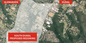
South Dural Residents and Ratepayers Group, a developer initiated lobby group, has made numerous applications since 1990 to Hornsby Council for the rezoning of 240 ha of rural lands in south Dural for urban purposes. The latest attempt is currently under consideration. Click here for details of the history of the lobbying
In the latest attempt, consultants’ reports have been commissioned as part of the first step of the application, that is, to change the zoning from rural to various levels of residential density and recreational zoning. Submissions closed on 2 December.
The spine of the proposed development is an area of bushland along Georges Creek and another unnamed tributary of Berowra Creek. Indeed the developer is touting the natural views and the tall forest as a feature that will allow six storey apartments to fit into an ‘eco-friendly’ community. All in all the proposal is for 2,900 dwellings that could house 9,000 people.
The bushland is of high conservation value with areas of Blue Gum High Forest (10.5 ha), Sydney Turpentine Ironbark Forest (22 ha), Blackbutt Gully Forest (30 ha) and Shale Sandstone Transition Forest (1.4 ha). The first two listed are classified as critically endangered ecological communities under the federal Environment Protection and Biodiversity Conservation Act.
As the opposing residents’ group, the Galston Area Residents Association, points out there are many reasons to oppose the application, for example:
- it is inconsistent with the metropolitan plan to preserve remaining rural land
- current roads cannot cope with current traffic let alone that generated by the extra residents
- public transport is inadequate and the north west rail line is a long way away so buses will have to operate on clogged roads
- there is insufficient provision for schools, shops, recreation areas and other basic infrastructure
STEP opposes the rezoning application for three main reasons:
1. Inadequate vegetation data and mapping
The bushland area comprises about 64 ha, a quarter of the site. As large parts of the land are privately owned it has not been possible to carry out on the ground vegetation mapping. This applies in particular to the area of Blue Gum High Forest of about 10 ha. This is in the context of the total area of Blue Gum High Forest remaining in Sydney of less than 200 ha. Other areas of significant vegetation have not been sampled adequately or consistently.
It is totally unsatisfactory to be asking the public to comment on such inadequate information, especially when dealing with endangered ecological communities.
2. The proposed zoning map does not reflect the described development or the stated purpose to conserve native vegetation
The higher density six storey buildings are planned to be built closest to the bushland but they are zoned R3 (medium density). It should be zoned R4, high density residential.
There are also inconsistencies in the minimum lot sizes of 125 m2 and 225 m2 stated in different parts of the proposal documents. The prospect of lot sizes of 125 m2 is alarming! No room for trees.
Most of the riparian areas are described as having high conservation significance so should be zoned as E2. However the proposed zoning is RE1. It appears the intention is to allow a gravity feed sewer to be installed along the creek lines, hardly compatible with conservation. Construction of a sewer would need road access that would damage the natural creek line and, on past experience, create a wide band of weed invasion.
3. Large areas of the zoning proposal are deferred
The deferred areas are the main bushland strips that interface between the residential areas and the core riparian areas. They cover a significant part of the bushland. The reason given is the uncertainty of the biodiversity legislation that had not been passed when the proposal was submitted.
These deferred areas will be hard to manage because of the proximity to the housing development so government agencies will probably not want them.
An absolute tragedy would occur if they were traded for biobanking sites elsewhere as it would be impossible to find equivalent vegetation communities to be restored to offset the losses. They should become areas that are off-limits to biobanking.
The effect of this proposal on the existing vegetation will be very damaging unless very detailed precinct plans to protect it are drawn up and very active and expensive management takes place in perpetuity.
It is unsatisfactory to expect the public to comment on this proposal with incomplete and inadequate information.
Summary
Ideally STEP would like this parcel of land to remain rural, but in the event of it being rezoned for residential development STEP would like the potential impact on biodiversity reduced. Possible mechanisms for this include:
- The RE1 zoning changed to E2 to allow better management of the biodiversity values
- The deferred areas to be zoned E2
- The areas zoned E2 to be managed by the local council with the provision of funding for long-term management from the developer
- The area currently proposed for R3 (medium density) should be greatly reduced with a zoning of R2 (low density) in areas with scattered trees
- Very limited R4 (high density) set well back from the bushland
- The minimum lot size for dwelling houses and semi-detached houses increased well above 225 m2, preferably up to 500 m2
- Find an alternative to gravity-fed sewers down the creeks
- Development set further back from the areas of biodiversity constraints so that the bushland edges are not as severely impacted
- Provision of buffering by revegetation should be considered along bushland edges
Expansion of Medium Density Housing

In the past, councils expended significant funds in formulating local environment plans with zoning locations appropriate for different areas. The particular zoning and its extent took into account the immediate and cumulative effects on local infrastructure, services, traffic, street car parking, social services and amenities. The matching development control plans gave consideration to the local character of the area, including streetscape, topography, shared views, and soils.
It now seems that the NSW Government is trying to overwrite these local powers by proposing a major expansion of medium density housing into low density housing areas. Details are provided in a discussion paper released in November 2015 called Options for Low Rise Medium Density Housing as Complying Development.