Our local and regional environment owes so much to its geological heritage. We live in the Sydney Basin, an epicontinental pile of sedimentary rocks several kilometres thick that was laid down in the Permian and Triassic periods between 300 and 200 million years ago, and our present landscape framework was created by tectonic uplift and erosion of its strata.
Abundant life in a chilly sea
We might think of our local landscapes in terms of its multiple sandstone tablelands, spurs and gorges. Their rocks were mostly laid down by fresh and brackish water in flood plains and estuaries, but the early history of the Sydney Basin incorporates a strong marine influence, and you can find abundant shelly fossils in numerous sites along the coast south of Wollongong. There's also much evidence that the sea at the time was icy cold and peppered with drifting, melting icebergs, and you can still view their dropped erratic, morainic boulders nestling amongst the fossils in cliffs and rock platforms. The mineral glendonite found down there only forms today in icy-cold sea floor mud – it was named after its discovery site at Glendon on the Hunter River. The global climate conditions captured by this older Sydney Basin suite is of national significance both to our scientific heritage and to a broader understanding of the earth's history.
A great extinction event
Towards the close of that chilly, early basin epoch, the seas gradually subsided and coal formed from the peat of boreal swamp forests, contributing historically to our region's strong economic base. But the coal story came to an abrupt end 252 million years ago with the great end-Permian extinction event, when massive volcanic outpourings on the far side of the globe bathed the planet in acidic gloom and warmed and dried its atmosphere.
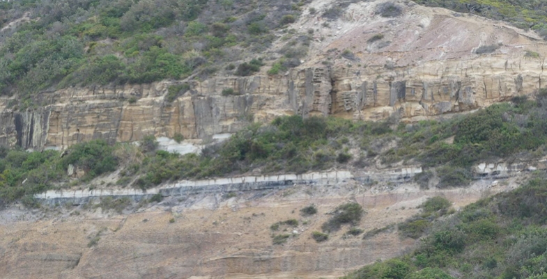
The evidence is beautifully preserved in cliffs south of Newcastle (pictured), north of Wollongong and also in the Blue Mountains.
This key event should be much more widely recognised and understood as its effects are mirrored in current climate change and extinctions. Our local geological heritage carries critically important environmental messages for today.
Plain old sandstones reveal fascinating stories
Some of our local sandstones were sourced from a long way off. Research on the Hawkesbury Sandstone based on radiometric dating has matched grains of a mineral called zircon with the same mineral in igneous rocks of the Transantarctic Mountains. Antarctica was joined to Australia at that time, and while still a long way off, the scale of the river system implicated is well within that of many flowing across present day continents.
Australia's membership of the supercontinents of Pangaea and subsequently Gondwana was the beginning of a story that flows right through to the roots of our floral diversity. Clearly it underpins our natural heritage.
Our sandstone's floral diversity
Our sandstone landscapes are built largely from nutrient poor but iron- and quartz-rich rocks that support an incredibly rich flora, many of whose species benefit from the buffering action of iron against phosphorus toxicity. The floral diversities of sandstone heathlands and shrublands in places like the Royal and Ku-ring-gai Chase are only surpassed in Australia by those of south-west WA, an internationally recognised biodiversity hotspot. Long term, the heritage value of our local bushland outstrips that of any of the temporary creations of human activity, however functional or beautiful they might be, and it must be preserved at all cost.
Dinosaurs, volcanoes and diatremes
The earlier paragraph on the great extinction event might also have mentioned that this kick-started the evolution of the dinosaurs, which of course ultimately led to the birds. The dinosaur era peaked in the Jurassic and Cretaceous periods between 200 and 66 million years ago before ending in that other great extinction event, and at that time the sedimentary rocks of the Sydney Basin were compacting and drying out.
But there was still enough water left in their pores and joints that when basaltic magmas trickled in from depth, it flashed it into superheated steam that shattered its way to the surface at numerous points around the region. In many cases the magmas wormed their way through the crevices of shattered rock to follow it to the surface, also to be blown to smithereens by explosive pressures. The volcano style of that time is known as a maar, and its feeding pipe a diatreme.
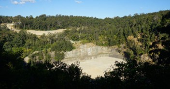
In our northern Sydney region we have the largest and best preserved diatreme in Australia in the Hornsby quarry. This has heritage value and is a geological site of international status. Fortunately it appears the filling of the quarry for the parkland project has preserved the upper faces and cleared them of debris, thus exposing the diatreme's classic layered structure (pictured).

Layering in the volcanic debris of the Hornsby diatreme
Photo at the top of the page: Ghosties Beach Munmorah: black coal followed by white sandstone band marks the extinction event
Dr John Martyn

