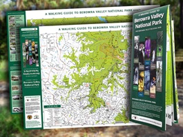
 The map is based on data supplied by the National Mapping Authority and includes tracks and walks. The double sided purpose-designed topographical map:
- shows approved walking tracks and fire trails
- references picnic and camping places, toilets, and important, notable and historic sites
- shows clearly marked track head access from public transport
- reproduces clear and specific safety guidelines for some tracks that cross the restricted Hornsby Rifle Range
- is printed on quality synthetic paper which handles wet conditions, repeated folding and tearing
- is folded for convenient part-opening to follow a track
- is cross-referenced to the Friends of Berowra Valley website
- describes and illustrates the ten walks in Guide to Berowra Regional Park (2004, out of print, 245 pp, more than 400 colour images)
The map costs $10 and is available from:
- our on-line shop
- Information Centre Bobbin Head
- Information Centre Lane Cove National Park
- Camp Hike Climb (George Sreet, Hornsby)
