
Displaying items by tag: bushland
Build-and-ride scheme at Grayling Reserve – a difficult balance
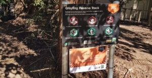
Grayling Reserve is a small area on the corner of Grayling Street and Binalong Street in West Pymble. It covers an area of about 1,300 m2. There is a creek on one side plus a narrow strip of bushland. Two sides are bounded by houses and the fourth side is a narrow entrance from Grayling Street. The remainder is a grassed area with a few saplings. Visibility of the grassed area is screened by the bushland.
In the bushland there are several large Blackbutt trees with hollows that are likely to be over 100 years old. These trees are increasingly rare in Ku-ring-gai and need special protection. There is one Blackbutt that would have a girth of about 5 m at the Grayling Street entrance. There is also a Lomatia myricoides (River Lomatia) and some Allocasuarina torulosa which are quite unusual in West Pymble.
The major part of the reserve is classified as critically endangered Sydney Turpentine Ironbark Forest on council mapping. The reserve is also an essential wildlife corridor.
The trees in the reserve used to be roosting sites for Powerful Owls, Boobook Owls and Tawny Frogmouths. Gliders have also been seen in the past and there are markings on the trees from their activity. The neighbours have advised that they have not seen this wildlife since the bike park disturbance occurred.
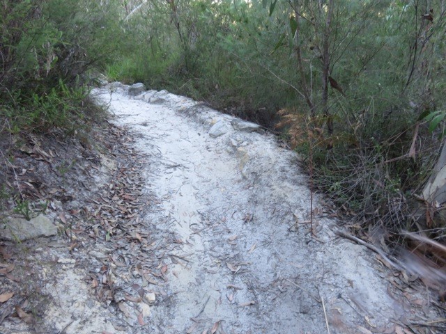
During COVID, in 2021, the locals started building bike jumps and paths in the cleared area of the park. This area is only small, about 900 m2. Even though this construction was unauthorised, council recognised the demand for this sort of informal facility. The building is an integral part of the fun as well as the bike riding.
After some consultation with the neighbours and an environmental assessment, in May 2023, council decided to trial making the bike park official and provided some dirt and tools to assist with building jumps.
Signs were erected advising the conditions of the trial, for example:
Do not dig, use the materials provided
Tread lightly, don’t harm bushland or plants
Keep the site clear of rubbish
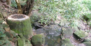
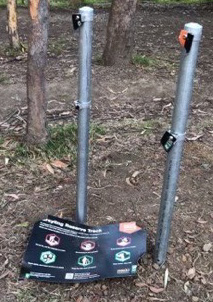 However, by July there were reports from neighbours of anti-social behaviour with older children harassing the younger ones, night time disturbance and dangerous riding in nearby streets. Trees were being damaged, some small Callicomas chopped down and dirt piled up against the Blackbutt at the entrance. Water was being taken from neighbouring properties. Creek crossings were being created interrupting the flow of the creek.
In response council placed temporary signs with stronger warnings in several locations around the site, for example:
Do not harm trees or plants or this track will be closed
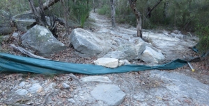
Damage continued and the signs were pulled down so council closed the site and undertook a survey of the local community.
This site is not suitable for a bike park
STEP’s submission argued that this area should be a reserve, that is a quiet space for passive enjoyment for visitors and habitat for wildlife; not a highly disturbed play area. The area is not visible from the street and is too small to be a useful bike park.
In September council responded to the consultation feedback by deciding to close the build-and-ride park trial, saying the reasons were the various environmental and social issues. The announcement noted that signposted conditions of use had been repeatedly broken by users. Details are here: .
The West Pymble Facebook page erupted with comments expressing outrage at the removal of a valued facility. It seems the value had been abused. However there is a strong interest in the concept of a build-and-ride site.
Often it is the build aspect that is the most popular – sand pits for bigger kids? Council is looking for suggestions from the public of sites suitable for trials of the build-and-ride concept.
Weeds in national parks along sewer lines, energy transmission lines
My concern is that weeds occur along all land that has been disturbed in otherwise pristine bushland areas. These are unsightly and continually invasive.
For example, the sewer lines constructed through Sydney in the 1950s and 60s have much unfinished business in bushland areas where the mains have been constructed.
Sydney Water, and before it, the Sydney Water Board never finished the environmental work of restoring the iconic bushland of the Sydney Basin; all part of the world-renown Sydney Bioregion. Custodial responsibility means carrying out work to ensure that environmental repairs are undertaken in a timely manner to sustain ecological integrity.
More than 20 years ago Sydney Water played an important and effective role in the active catchment management committees (CMCs) which were set up by the NSW Government. I know this because I was deputy chair of the Lane Cove River CMC. CMCs and CMAs were set up as a consequence of concerns from my then local MP, who was The Hon Tim Moore.
It is even more important in present times that these matters of concern then be reactivated. CMCs need to be reactivated and incorporate members of all government entities implicated. Untreated weed outbreaks do not disappear over time; they tend to exacerbate. This also means energy authorities, such as Ausgrid and the Roads and Maritime Services.
My recent walks in the Lane Cove National Park attest to this. Roads and Maritime Services are apparently doing nothing in the area around de Burghs Bridge and the former bridge.
All public authorities who do construction work through bushland must be held environmentally responsible for ensuring regeneration work in the areas disturbed; or previously disturbed, until they again become ecologically stable.
As a former teacher of bush regeneration at TAFE, it is clear to me that there are on-going responsibilities that have not been addressed. All these major service providers have the capacity to pay. There is no excuse for walking away from land management obligations. Especially in pristine natural bush. This applies to all areas that have had physical disturbance and on-going access by vehicles that carry weeds in their tyre treads, etc.
Such environmental work should not be left to the National Parks and Wildlife Service to do the ‘cleaning-up’.
Please inform me of the present status of environmental responsibility within Sydney Water, energy authorities and Roads and Maritime Services, especially with regard to assessment, action and monitoring, until an ecologically functional and stable state is reached and maintained over time.
I realise this will require a whole new approach and will require service providers to environmentally Care for Country. It must be done together with local government.
However, it MUST be done.
This is a letter sent to the Minister for the Environment, Matt Kean, by Janet Fairlie-Cuninghame. Janet is highlighting a problem that is very evident when walking along creek lines. We hope she receives a constructive response. National Parks staff have a huge job to do currently with so many people using national parks for recreation. This is also an expensive issue for local councils.
Mountain Bikers Continue to Abuse the Environment
Ku-ring-gai Council’s decision to close the Warrimoo Downhill Mountain Bike Trail was taken in July 2016 (see STEP Matters 188). We all thought that this decision would be respected by the downhill bike riders given the strong reasons for its closure. We were wrong! This is not the only area that is being abused by these arrogant individuals. We recently discovered another track in Garigal National Park and have heard of many others. The details below explain why these cowboys must be stopped.
 Warrimoo Area
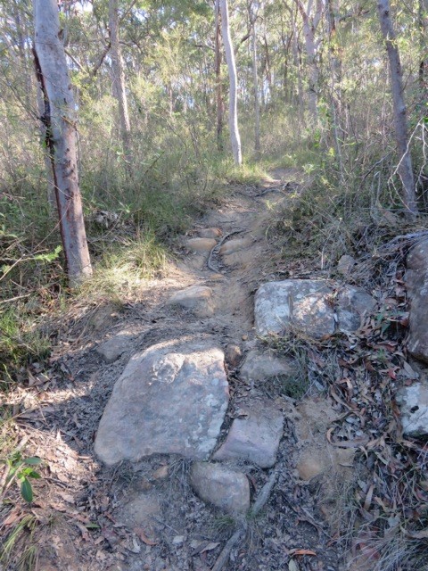
The track below Warrimoo Oval must have taken a lot of effort by several people to construct. It contains multiple jumps, ramps and curves as shown above and right. It could only be used by expert thrill-seeking riders. The independent report commissioned by council stated that the average decline is over 23% whereas the standard used for downhill trails is that they should be no more than 10%. Hence it is risky.
The major reason for closure is the ecological damage caused by the track construction and its continued use. The area contains an endangered ecological community called Coastal Upland Swamp and is also habitat for several threatened native birds, plants and animals. A STEP committee member who is a volunteer in a council-run Eastern Pygmy Possum monitoring project has observed threatened Eastern Pygmy Possums and Rosenberg’s Goanna. Under NSW and federal environmental laws, council is required to protect and conserve this ecological community and the native animals and birds that live within it.
The construction involved bush rock removal, clearing of native vegetation, removal of dead trees and wood, infection of native plants by Phytophthora cinnamomi and changes to landscape hydrology, which is adversely affecting the Coastal Upland Swamp and individual threatened species.
During a visit to the area just after the recent school holidays it was discovered that barriers and signs on the track installed by council had been shoved aside. The tyre marks along the track indicated that riders were still using the track. In 2016, council installed signs warning about video surveillance and explaining the reason for closure. These are being ignored.
This track and other downhill tracks are shown on some mountain biking websites encouraging this illegal use.
Following discussions with the local mountain bike community, council is working on options to reopen part of the trail that is south of the Coastal Upland Swamp. This involves completing an ecological feasibility study and consulting with an experienced mountain bike trail builder to see if suitable track modifications can be made with satisfactory ecological and safety outcomes. Given the steepness of the site and disturbance of the bushland reopening of the track is not guaranteed. The study will be completed by mid-2018.
Garigal National Park
 We have also discovered a new mountain bike track that has been carved through high quality bushland below Cambourne Avenue in St Ives down to Middle Harbour Creek. It takes a straight line down the hill while the legal management trail zigzags across the slope.
This is another area where threatened species have been found, namely the New Holland Mouse and also the Eastern Pygmy Possum.
Again a lot of work has gone into constructing ramps and jumps – see photo.
We encountered two riders who didn’t care that they were breaking the law and possibly causing untold damage to threatened fauna as well as their habitat, the bushland with large numbers of species providing food for these animals.
The law is that mountain bikes are allowed in national parks and council land on fire trails, roads and management trails and signage is provided to confirm that cycling is permitted.
These riders think their needs are too important for them to have to wait for the proper process of downhill track construction. This involves surveying plant and animal species that will be affected by bike riding. A route needs to be chosen that will cause minimal damage to the bushland and then a track is built that will be safe, resilient to weather and usage pressures. This process takes time and is expensive.
STEP is not happy about the two tracks that were built in the Frenchs Forest part of Garigal National Park, the Gahnia and Serrata tracks, because they traverse high quality bushland and their usage is likely to lead to introduction of pathogens and weeds and changes in hydrology. However the quality of construction means that their usage over the past two years has not caused any obvious damage so far. We understand that these two tracks cost over
$1 million to build.
Certainly there is a growing demand for mountain biking facilities and we should be encouraging participation in active outdoor sport like this but there are many trails available that can be used legally.
There is also a strong demand for the adrenalin rush of steep downhill rides but this must not be at the expense of damaging quality bushland that is already under attack from urban development and climate change (drought, bushfire). It is not as if the riders could possibly appreciate the bushland as they speed down a hill paying close attention to the next obstacle on the track.
NPWS needs the resources to prevent the construction of these illegal tracks.
What can we do?
The best we can do is alert the authorities, national parks rangers and council staff about any track we see when out walking in the bush. Also alert your local MP about your concerns and the need for more policing of illegal activities.
Ku-ring-gai Council’s Review of its Recreation in Natural Areas Strategy
Ku-ring-gai Council is currently undertaking a review of policy for managing recreation in bushland areas. This will cover the way people use the bushland for activities such as walking, trail running, rock climbing, abseiling, bouldering, mountain biking, orienteering and trekking. The strategy aims to support a diverse and accessible range of recreation opportunities for the community in a way that protects and enhances our local environment.
A consultation process is starting firstly with representatives of interest groups. They will then seek further input via a community meeting and a public exhibition of the draft strategy including an online forum. After consulting the community, the strategy will be finalised for adoption by council. The whole process should be completed by December 2018. We will keep you updated with developments.
Development of Crimson Hill, the Old UTS Site
Firstly, some history; in 2003 UTS decided to vacate the site and sought a rezoning for residential development with 560 buildings. Ku-ring-gai Council refused the application so the state government intervened and declared the site to be a Part 3A project under the EPAA Act. The Minister for Planning became the decision maker.
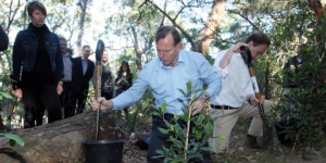
STEP was a member of a community consultative committee established to demonstrate that the community had been consulted. The committee opposed many aspects of the development plan. There were some wins in the transfer of 9 ha of the land to management by Lane Cove National Park and some improvements including a reduction in the number of dwellings approved for the site, the retention of a full-sized oval for community use and the retention of heritage buildings.
Of course there are no additional funds available to the NPWS to manage the additional national park land. A significant area of bushland has been modified to establish the asset protection zone and of course there will always be traffic and parking problems especially when the new school is operating. The management of stormwater and the risk of weed encroachment will need to be closely monitored.
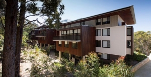
Crimson Hill – Defence Housing Australia (DHA)
Crimson Hill estate was designed along simple, environmentally sound principles aimed to establish a new integrated community connected by bushland trails and elevated walkways. The objective was to promote community interaction and well-being. It has 345 dwellings occupying a portion of the 12.6 hectare site of rezoned land that DHA purchased from UTS in March 2011.
A significant area of this land, including publicly accessible bushland and nature trails for bushfire management, is in the care of the new residents via a Community Management Association.
It is DHA’s first multi-residential housing project and is being constructed in five phases. The name is a salute to the colour of the ribbon on the Victoria Cross medal. Each residential precinct is named after one of the five recipients of the VCs awarded for bravery on a single day during the battle of Lone Pine in 1915:
- Burton’s Place – Alexander Stewart Burton
- Dunstan Grove – William Dunstan
- Tubb’s View – Frederick Harold Tubb
- Hamilton’s Corner – John Hamilton
- Shout Ridge – Alfred Shout
The estimated 700 residents, expected to occupy Crimson Hill eventually, comprise a mix of Defence personnel and civilians. There are many owner-occupiers and tenants.
DHA is an Australian government enterprise established by the Defence Housing Act 1987 to supply housing and related services to Australian Defence Force members, in-line with operational requirements. Launched in 1988 as a statutory authority, DHA is now a commercially-funded organisation that has projects all over Australia. During 2015–16, DHA managed 18,767 properties for ADF members and civilians.
Before construction commenced in 2013, the brownfield site had significant areas of native remnant bushland around the university campus. A detailed ecological assessment was done before any clearing started.
Indigenous seeds were collected from endemic species and these were replanted. It is estimated that over 90% of plants on the site now are native and the majority are locally occurring species.
The centrepiece of the estate is Charles Bean Sports Field, opened in December 2013. It was developed by DHA with Ku-ring-gai Council and the Northern Suburbs Football Association. The purpose-built, publicly-accessible sports field has received FIFA 2-star certification, the highest accreditation an artificial grass field can receive. There are football teams coming and going continually and it is rare to see the field without players on the evergreen surface.
Rainwater is harvested within the buildings for re-use and some have solar panels to reduce main-grid energy usage. Environmental consultancy Cundall, estimates the buildings will use 60% less energy and water than standard multi-residential developments. The residential development was designed by two architectural companies: Bates Smart and Architectus. Construction was by two building companies: Grindley and Ganellen.
The recently finished Shout Ridge is the first apartment building in Australia to receive a prestigious 6-Star Green Star – Multi Unit Residential Design V1 certified rating for environmentally sustainable design from the Green Building Council.
New School on the Horizon
The latest good news for Lindfield residents is that planning is underway for a major refurbishment of the empty UTS building that remains from its previous use as a university. The building is earmarked to become a new K to 12 school.
The large concrete building was handed over to the NSW Education Department as part of a land swap with UTS. Eventually 2,000 primary and secondary students are anticipated to attend the new school. It hopes to have high quality technical spaces for science, engineering, hospitality, visual and performing arts, as well as music and film. And there will be a childcare facility.
The former UTS building has architecturally heritage because it won the prestigious Sulman Medal for architecture in 1978. This is the highest award given in Australian architecture.
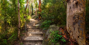
New Walking Track
NPWS and DHA, with the assistance of Friends of Lane Cove National Park, are building a new track from Crimson Hill to Lane Cove National Park. Locals will be able to walk along this bushland track and stroll among wonderful angophora, wattle and eucalypt trees to get down easily to Lane Cove National Park all without any need to get into a car. At a construction cost of more than $220,000, the track will be one more amenity for the residents of Crimson Hill and other locals.
Note: As it is, the track is not shown on our new map, Walking Tracks of the Lane Cove Valley. An example of how hard it is to keep up-to-date.
Lots More Development
As President of the Friends of Lane Cove National Park, Tony Butteriss points out in Regenavitis, wherever you look in Sydney now, there is more development and if feels as if it is getting closer to Lane Cove National Park. There are numerous projects coming right on the edge of the Park including the old UTS site, old Screen Australia site (adjacent) and redevelopment of the Acoustic Laboratory. However, the development that makes all the others look as if they are only playing, is the one at the Epping Road end of Delhi Road. Strictly speaking it is not one but at least three different developments planned to have a total of more than 2,200 units. This will have an impact of (at least) 5,000 people.
This particular development is a worry but consider the cumulative effect of all of them. Each development reduces habitat surrounding the Park. Each brings more hard surfaces and increases the speed of run-off after storms. And each brings visitor overcrowding to the Park. What can local groups do about this? The Friends hope to persuade the developers to fund some restoration projects.
The February edition of Regenavitis, the newsletter of the Friends of Lane Cove National Park, included the following update on the development of the former UTS (Ku-ring-gai) site in Lindfield that is now called Crimson Hill. We thank them for permission to reprint.
Click here for more information on the campaign.
District Plans
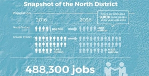
Have your say on the North District Plan and the Greater Sydney Strategy by 31 March 2017.
District Plans cover the plan for growing Greater Sydney in detail. Sydney is divided into six districts and ours is the North District.
Increase in Number of Dwellings
The table below summarises the implied new dwelling requirements from the population growth rates adopted in the Greater Sydney Strategy.
| Council | Existing 2011 | 2011–16 | 2016–21 | 2021–26 | 2026–31 | 2031–36 | Change 2011–36 | % change 25 years |
| Lane Cove | 13,900 | 1,650 | 1,350 | 1,250 | 1,900 | 1,900 | 8,050 | 58% |
| Ryde | 44,050 | 4,950 | 6,250 | 5,650 | 5,100 | 5,000 | 26,950 | 61% |
| Hunters Hill | 5,400 | 350 | 150 | 150 | 200 | 250 | 1,100 | 20% |
| Northern Beaches | 103,800 | 4,950 | 2,900 | 4,050 | 5,100 | 5,400 | 22,400 | 22% |
| Mosman | 13,750 | 550 | 300 | 250 | 350 | 400 | 1,850 | 13% |
| North Sydney | 37,000 | 2,950 | 2,750 | 2,700 | 3,100 | 2,900 | 14,400 | 39% |
| Willoughby | 29,050 | 1,900 | 1,200 | 1,400 | 1,850 | 2,000 | 8,350 | 29% |
| Ku-ring-gai | 41,050 | 3,150 | 2,750 | 2,850 | 3,300 | 3,250 | 15,300 | 37% |
| Hornsby | n/a as boundaries have changed | |||||||
Here is an example of how the increase in dwelling numbers could come from replacement of existing houses with higher density dwellings. If the average replacement ratio is three new dwellings for one original dwelling in Lane Cove, around 4000 existing homes (around 30% of the suburb) would be replaced by 12,000 new terraces/townhouses over 25 years.
The sheer scale of new housing and infrastructure that will be needed to accommodate the increase in population over the period 2016–36 means that the character of northern Sydney will change. That will not be the end of it. The growth is not expected to stop once 2036 is reached!
The financing for this development could create pressure for sale of public land. Alternatively it could be financed by concessions in the height and location of high-rise. Dwellings near open space (including bushland) are more valuable and provide greater capacity for ‘value capture’. We see this approach in the proposals for development in South Dural where the developer is applying for approval of six storey buildings adjoining a riparian zone.
Protection of Native Vegetation
STEP’s main area of interest is the likely impacts of extensive further development on our existing bushland and native vegetation and what the District Plans have to say about the future development and management of these areas. We are also concerned about the environment of Sydney in general with issues like:
- Will natural bushland on public and private land be maintained and improved?
- Will the green canopy cover from street trees and suburban gardens be maintained?
- Will there be sufficient wildlife corridors and preservation of habitat, eg tree hollows?
- Will the planning regulations allow developers to remove excessive amounts of vegetation?
- Will there be preparation for climate change in management of riparian zones and foreshores?
The North District Plan is a frustrating document. It makes encouraging statements but then provides little detail on how the intentions will be actioned.
It emphasises the rich natural environment of the North District located in national parks and reserves, public and private land (p131).
It states that more effective outcomes can be delivered through planning at a strategic level that:
… can consider opportunities to connect areas of biodiversity, the relationship between different areas and threats to natural features.
Does this mean considering cumulative impacts and wildlife corridors?
The future status of natural areas is unclear. Natural areas that are currently cared for under council plans of management need to continue to have protection as a special category of public land use. The Department of Planning has been reviewing the State Environment Planning Policy 19 that defines protection of urban bushland for well over a year. We should have this information by now so we know how it fits in with the District Plans. We understand that Tree Preservation Orders are included in this review.
The whole process is a quantum change from the past where a regulatory planning system, such as SEPPs protected our natural areas. We now have a strategic planning system which facilitates further development intensity and the strength of the regulatory protection is unclear.
The future conflicts are exemplified by the stated objectives of strategic conservation planning (p132), for example:
- Maintain and where possible improve the conservation status of threatened species and ecological communities.
- Achieve better outcomes for biodiversity conservation.
- Facilitate urban growth and development and reduce the cost and timeframes for development approvals.
- Provide an equitable model recognising and recovering the cost of biodiversity impacts from urban growth (the questionable offsets system).
Specific Issues
Some examples of specific issues that need to be addressed in the North District include:
- Protection of Gordon Flying Fox Reserve – flying foxes are a keystone species that are essential for the cross-pollination of native trees and their ability to adapt to climate change.
- Ensuring critically endangered ecological communities including Blue Gum High Forest and other rare vegetation are protected by the classification as Nature Reserves. These reserves are isolated pockets that are encroached by housing development. Bushland buffers need to be maintained around these endangered forest areas as well measures to ensure that the trees are not damaged by urban stormwater.
- Recognition of the special environmental attributes of the northern areas with unique vegetation arising from high rainfall and Wianamatta Shale Soils.
- The need for an upgrading of the BASIX requirements to allow for more extreme rainfall events that are accelerating damage and erosion to riparian zones. This is particularly noticeable due to the high energy water flows associated with the steep catchments in the North District.
Green Grid
The development of the Green Grid through the Metropolitan Greenspace Program is lauded by the District Plan as an important part of promoting a healthy environment. Broadly the Sydney Green Grid program is all about improving recreational spaces and their accessibility, including access to national parks. STEP is very concerned if it includes developments like bike trails through uncleared bushland, or exploitation for tourism such as leasing public land within national parks for hotels and camping areas.
The North District Plan refers to a detailed report that outlines the conceptual approach behind the Green Grid that is on the website. On enquiry we discovered that it has still not been released. Lack of key information including the changes to SEPP 19 is unacceptable and undermines the purpose of public consultation of the North District Plans.
The Greenspace program is funded by regular grants. $3 million was provided in 2015–16 and $4 million in 2016–17. $50,000 is going towards improving bush tracks in Hornsby. There is no long-term commitment to fund the program.
The North District Plan identifies some priority projects (p137). The proposal for Lane Cove River area is a concern. The description is:
Enhancing open spaces along the Lane Cove River foreshores to create unique recreational experiences linking the Lane Cove National Park to Macquarie Park. Macquarie University, Chatswood and Epping.
Will this involve clearing national park land? Currently this area of the river provides highly diverse habitat areas for native animals. On a recent STEP walk 50 native bird species were recorded. Mountain bike trails have so far been excluded from the LCNP. The area needs protection from high recreational use.
We have an opportunity now to tell the Greater Sydney Commission what is needed to ensure that Sydney’s unique environment is not destroyed by population growth.
South Dural Development Stopped … For Now

We've previously summarised our concerns about the application to rezone rural land to residential land. It is a relief that Hornsby Council has decided to discontinue evaluation of the proposal. But this is only until an infrastructure and funding plan is in place for this and other developments in this rural area.
Over 5,000 submissions were made opposing the development, many for reasons other than congestion along New Line Road and lack of other infrastructure. There will be more opposition to come when the developer has another go. With any luck the proposal will be deemed inconsistent with the North District Plan that aims to retain rural land.
Why Give the Green Army its Marching Orders?
It’s a rare week when natural resource management policy penetrates the national news cycle not once, but twice.
Nonetheless, last Thursday the federal government struck a deal with the Greens to increase funding to Landcare programs by $100 million in exchange for their support on other matters. No one quite seems to know yet how this money will be spent – presumably in ways that support the thousands of volunteer community Landcare groups dotted around Australia.
Then on Sunday, the Australian Financial Review reported that the government will abolish the Green Army program as part of its mid-year budget update later this month.
Introduced in 2014 as a signature policy under the then prime minister, Tony Abbott, the Green Army aimed to mobilise 15,000 young and unemployed people to work on conservation projects and receive complementary training. Axing the program would deliver budget savings of around $350 million.
Abbott took to Facebook on Monday to criticise the move. His main concern seems to be the implication that the Greens’ policy priorities are more important than the Coalition’s. That’s a bad look, he argues, for a 'centre-right government'.
Yet the move would arguably be very much in keeping with centre-right values. By reinvigorating Landcare’s model of personal responsibility and self-regulation, the government could reduce pressure to regulate land use or to pay landholders financial incentives to improve their environmental management.
But consistency with any particular political philosophy is not the issue here. The hyper-polarised political landscape of recent years, particularly on environmental policies, encourages parties to differentiate on any grounds they can. Thus, the cross-party support long enjoyed by Landcare can perversely work against it. Incoming governments believe they need new programs to claim as their own, diverting attention and resources from those already in place.
The $484 million cut to Landcare in the 2014 budget needs to be remembered in this context. Both Coalition and Labor governments have made changes over the years that either reduced the financial support available to community Landcare groups, or imposed more top-down modes of decision-making.
The 2015 Senate inquiry into the National Landcare Program revealed considerable community concern about the impacts of budget cuts on Landcare’s activities and on private commitment to natural resource management. Every dollar of public money invested in Landcare is believed to leverage between $2.60 and $12.00 of community and landholder investment.
When the Green Army was launched, many people questioned whether it would deliver this kind of value for money. With a three-year review of the Green Army due for release early next year (subject to ministerial approval), we might have expected to see some answers.
So why is the Green Army is being cut before the review? Perhaps the government is sparing itself the embarrassment of defending a program that is failing to meet its objectives. Perhaps, despite the critics, the findings would have been positive and the government is avoiding having to explain why the Green Army is being killed off anyway. Perhaps it’s just looking for easy budget savings.
Strategic plan?
Whatever the motivation, the biggest concern is the absence of a strategic and coherent approach to natural resource management policy in Australia. Major program changes are being made with limited consultation and transparency, and precious little evidence of planning.
At the same time, some policies and programs appear to be working at cross purposes. For example, tree clearing is increasing in much of Australia at the same time that some landholders are being paid through the Emissions Reduction Fund to conserve native vegetation.
Questions need to be asked about the genuine impacts of existing policy, about the way in which regulations intersect with voluntary programs, and about coordination between Commonwealth and state governments, among other issues.
The recent Senate inquiry into Landcare called for long-term investment and stability in natural resource management programs. Achieving this will require a return to genuine cross-party support coupled with broader community and industry support. The key to achieving this, I suspect, is less wheeling and dealing among political parties and more consultation and planning with all interested stakeholders.
It might be time to consider a white paper process to inform the next phase of natural resource management policy. At least that would give us some confidence policy is not being decided on the run.
Stewart Lockie, Director, The Cairns Institute, James Cook University
This article was originally published on The Conversation. Read the original article.
South Dural Rezoning Proposal is Alarming
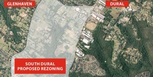
South Dural Residents and Ratepayers Group, a developer initiated lobby group, has made numerous applications since 1990 to Hornsby Council for the rezoning of 240 ha of rural lands in south Dural for urban purposes. The latest attempt is currently under consideration. Click here for details of the history of the lobbying
In the latest attempt, consultants’ reports have been commissioned as part of the first step of the application, that is, to change the zoning from rural to various levels of residential density and recreational zoning. Submissions closed on 2 December.
The spine of the proposed development is an area of bushland along Georges Creek and another unnamed tributary of Berowra Creek. Indeed the developer is touting the natural views and the tall forest as a feature that will allow six storey apartments to fit into an ‘eco-friendly’ community. All in all the proposal is for 2,900 dwellings that could house 9,000 people.
The bushland is of high conservation value with areas of Blue Gum High Forest (10.5 ha), Sydney Turpentine Ironbark Forest (22 ha), Blackbutt Gully Forest (30 ha) and Shale Sandstone Transition Forest (1.4 ha). The first two listed are classified as critically endangered ecological communities under the federal Environment Protection and Biodiversity Conservation Act.
As the opposing residents’ group, the Galston Area Residents Association, points out there are many reasons to oppose the application, for example:
- it is inconsistent with the metropolitan plan to preserve remaining rural land
- current roads cannot cope with current traffic let alone that generated by the extra residents
- public transport is inadequate and the north west rail line is a long way away so buses will have to operate on clogged roads
- there is insufficient provision for schools, shops, recreation areas and other basic infrastructure
STEP opposes the rezoning application for three main reasons:
1. Inadequate vegetation data and mapping
The bushland area comprises about 64 ha, a quarter of the site. As large parts of the land are privately owned it has not been possible to carry out on the ground vegetation mapping. This applies in particular to the area of Blue Gum High Forest of about 10 ha. This is in the context of the total area of Blue Gum High Forest remaining in Sydney of less than 200 ha. Other areas of significant vegetation have not been sampled adequately or consistently.
It is totally unsatisfactory to be asking the public to comment on such inadequate information, especially when dealing with endangered ecological communities.
2. The proposed zoning map does not reflect the described development or the stated purpose to conserve native vegetation
The higher density six storey buildings are planned to be built closest to the bushland but they are zoned R3 (medium density). It should be zoned R4, high density residential.
There are also inconsistencies in the minimum lot sizes of 125 m2 and 225 m2 stated in different parts of the proposal documents. The prospect of lot sizes of 125 m2 is alarming! No room for trees.
Most of the riparian areas are described as having high conservation significance so should be zoned as E2. However the proposed zoning is RE1. It appears the intention is to allow a gravity feed sewer to be installed along the creek lines, hardly compatible with conservation. Construction of a sewer would need road access that would damage the natural creek line and, on past experience, create a wide band of weed invasion.
3. Large areas of the zoning proposal are deferred
The deferred areas are the main bushland strips that interface between the residential areas and the core riparian areas. They cover a significant part of the bushland. The reason given is the uncertainty of the biodiversity legislation that had not been passed when the proposal was submitted.
These deferred areas will be hard to manage because of the proximity to the housing development so government agencies will probably not want them.
An absolute tragedy would occur if they were traded for biobanking sites elsewhere as it would be impossible to find equivalent vegetation communities to be restored to offset the losses. They should become areas that are off-limits to biobanking.
The effect of this proposal on the existing vegetation will be very damaging unless very detailed precinct plans to protect it are drawn up and very active and expensive management takes place in perpetuity.
It is unsatisfactory to expect the public to comment on this proposal with incomplete and inadequate information.
Summary
Ideally STEP would like this parcel of land to remain rural, but in the event of it being rezoned for residential development STEP would like the potential impact on biodiversity reduced. Possible mechanisms for this include:
- The RE1 zoning changed to E2 to allow better management of the biodiversity values
- The deferred areas to be zoned E2
- The areas zoned E2 to be managed by the local council with the provision of funding for long-term management from the developer
- The area currently proposed for R3 (medium density) should be greatly reduced with a zoning of R2 (low density) in areas with scattered trees
- Very limited R4 (high density) set well back from the bushland
- The minimum lot size for dwelling houses and semi-detached houses increased well above 225 m2, preferably up to 500 m2
- Find an alternative to gravity-fed sewers down the creeks
- Development set further back from the areas of biodiversity constraints so that the bushland edges are not as severely impacted
- Provision of buffering by revegetation should be considered along bushland edges
Climate Change Implications for Local Bushland
The Ku-ring-gai Bushcare Association is an unincorporated organisation that is supported by Ku-ring-gai Council which supports the Bushcare volunteer program and holds regular educational events. The committee comprises elected volunteers and Council employees.