
Displaying items by tag: Warragamba Dam
Warragamba Dam wall raising
Nothing has been happening with the Warragamba Dam wall raising proposal for some time. The idea was first raised by Premier Michael Baird in June 2016. The cost is prohibitive and the EIS has been roundly criticised for lack of detailed analysis of the impact on indigenous sites and biodiversity. Also the EIS relies upon biodiversity and cultural surveys conducted before the unprecedented wildfires of 2019–20.
The federal environment minister still has to give the go-ahead to a project that will damage the World Heritage Blue Mountains. There is no funding contribution promise from the federal government or commitment from the NSW Government.
Yet the premier, Dominic Perrottet announced suddenly in October that the project is declared to be critical state significant infrastructure. This apparently will be an election winner for the Liberal Government in western Sydney even though flood modelling shows that it will not solve the problem of inundation of some suburbs as much of the water comes from rivers that enter the Hawkesbury Nepean system below the dam wall.
Critical state development means it can progress more quickly through approval processes and will be more difficult to oppose in the courts.
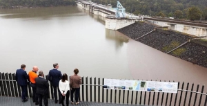
The NSW Department of Planning and Environment is now reviewing further community input on the proposal to raise Warragamba Dam wall, following the release of WaterNSW’s response to submissions and a preferred infrastructure report. The response dismissed most of the concerns raised in the 2,500 submissions. It even opens the possibility for changing the World Heritage area boundaries, in an attempt to avoid Australia’s international obligations.
The report reveals that health officials mirrored the concerns of Sydney Water, saying they had:
…concerns for drinking water quality during the construction and operation of the flood mitigation works proposed.
The extra water held behind the raised dam wall was: ‘likely to affect water quality’ in the dam during periods of flooding because of ‘increasing turbidity, colour and organic material’ from new parts of the catchment.
Nothing but bad news for Warragamba Dam’s wall raising project

There have been several items of news that are making the Warragamba Dam project look increasingly less likely to proceed. Nevertheless, Stuart Ayres, the Minister for Western Sydney, is still determined to go ahead. He has dismissed the objections about the impacts on biodiversity and cultural heritage as unimportant. He argues that the flood mitigation that the wall raising is meant to achieve is vital.
The project is not the panacea that he promotes. The dam does not hold back flood waters from the several rivers below the dam that can flood the Hawkesbury Nepean Valley.
The insurance industry has suggested that houses on land that ‘should have never been developed’ below the 1 in 100 year flood level could be resumed. The cheaper mitigation option is to improve the roads and other infrastructure so it will be easier to escape a flood.
Several NSW government agencies have attacked the Environmental Impact Assessment (EIS) prepared by WaterNSW that was released in September, for example:
- the Environment, Energy and Science division of the Department of Planning noted that WaterNSW’s evaluation of the project’s impact on World Heritage values is based on ‘incorrect assumptions’
- the assessment of aquatic ecology had failed to identify that raising the dam wall would result in inundation of about 284 km of rivers and streams during floods
- the EIS' conclusion that the project would have minimal impact on threatened species was ‘not supported by the data or evidence’
- Heritage NSW's response to the EIS indicates that the assessment underestimated the area’s cultural significance, saying the impact to Aboriginal cultural heritage values would be ‘significant’
The International Union for the Conservation of Nature reported this month that the Greater Blue Mountains would be likely to lose their World Heritage status if it went ahead. They wrote to the federal government last month expressing their concerns about the EIS.
The assessment process is in the hands of the NSW government under the bilateral agreement with the Commonwealth, an arrangement that has been a cause for concern. Over 2000 submissions were received during the consultation period of which only 45 were in favour of the project.
Now the NSW government will have to do more work on the EIS, a process that will cost a lot more taxpayers’ money.
More Bad Decisions by the NSW Government
In recent months there have been several more bad policy decisions by the NSW government that go against scientific common sense. Under this government many environmental protections have been reversed. The election in March 2019 will be critical in turning around this adverse situation. Here is a brief summary of the major recent decisions.
1. Backflip on the Sydney Marine Park Sanctuary Zones Proposal
The only NSW coastal region that currently does not have a marine park is the Hawkesbury Shelf marine bioregion that stretches from Newcastle to the Wollongong coastal waters. A long process of campaigning and consultation has been undertaken on the creation of a park. Finally an announcement was made on consultation on a draft marine park plan. The proposal included fully protected sanctuary (no fishing) zones that covered only 2.4% of the marine area including estuaries and other protected zones that restrict line and spear fishing.
A group of recreational fishers protested vocally blowing the restrictions all out of proportion. The Minister for Primary Industries promptly decided to withdraw the sanctuary zones from the plan. A knee jerk reaction that threw out the window all that scientific consultation and discussion. Evidence shows that sanctuary zones are essential for preserving and restoring the marine estate for future generations.
The draft plan provided limited protections even before the backflip. In addition to the conservation areas covering only limited areas, these zones would allow taking of lobster and abalone. Lobsters are important for controlling the numbers of sea urchins that devour kelp that are a vital source of food for many species. The increase in sea temperatures from climate change is already causing a boom in sea urchin populations.
Consultation on the draft marine park plan closed at the end of September.
2. Raising Warragamba Dam Wall
In the Issue 192 of STEP Matters we described the pointlessness of the claim that raising the Warragamba Dam wall will provide flood protection for the Hawkesbury Nepean Valley. There are five other rivers below Warragamba Dam that flow into the valley. The wall-raising proposal will cause huge damage to the pristine wilderness and wild rivers of the World Heritage Blue Mountains National Park, drown several Aboriginal cultural sites and destroy threatened plants such as a significant proportion of what remains of the critically endangered Camden White Gum Forest and the habitat of the Regent Honeyeater.
An environmental impact and economic assessment has not been done but last month the government passed legislation to change the National Parks Act to allow inundation of the park, a first step to facilitate the proposal. Everybody is saying that the real reason for the plan is to reduce the risk of flooding of all the new homes that the government wants to build in the North West Growth Centre. But that cannot be 100% assured by raising the dam wall. Flood data experts argue that management of the water level in the dam and even using the idle desalination plant would be more effective and less costly.
3. Protection for Feral Horses in Koscuiszko National Park
This issue was covered in STEP Matters, Issue 196. The government is ignoring protests from people concerned about the welfare of the horses as well as the damage they are doing to the sensitive alpine vegetation. The opposition parties have vowed to repeal the legislation if elected. A walk is currently being held from Sydney to Mt Kosciuszko to raise awareness of the issue.
4. Proposal to Revoke the Murray Valley National Park Status
A National MP has presented a private member’s bill in parliament that would delist the Murray Valley National Park. This would open up the area for logging of the river red gums. Only 5.5% of Riverina bioregion is protected compared to the international target of 17% for each region. The bill is unlikely to be debated before the state election but it sets a terrible precedent.
These recent developments are on top of previous bad decisions such as removal of land clearing controls or their replacement with weak offset provisions. 99% of identified koala habitat on private land can now be cleared without restriction. There is already evidence of the predicted increase in land clearing even though the act only came into operation in August 2017. A study commissioned by the NCC and WWF of satellite images of north-western NSW covering the Moree and Collarenebri areas showed that the area cleared in 2017–18 was triple the area in 2016–17.
The NSW government has announced funding for purchasing koala habitat from private landowners and conversion of unproductive state forests to conservation but this is not considered enough to make any difference to the need for secure habitat. A Koala national park is a must.
How Should the Flood Risk from the Hawkesbury Nepean be Managed?
The NSW government thinks that raising the spillway wall of Warragamba Dam by 14 m will significantly reduce the risk of floods inundating homes in western Sydney. But experts have questioned whether the raising will achieve worthwhile benefits and whether the ecological damage can be acceptable. They argue the water levels in the dam storage should be better managed instead.
Brief History of Sydney’s Water Supply
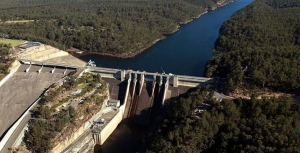
The first water supply dams built to supply Sydney were the Upper Nepean dams (such as Avon and Cataract Dams) that still provide 20-40% of our supply. When this supply became inadequate the next step was the construction of Warragamba Dam that commenced in 1948 and was completed in 1960. The resulting storage in Lake Burragorang is one of the largest reservoirs for urban water supply in the world.
Following 1988 and 1989 high rainfall years, the NSW government re-evaluated the potential rainfall and flood risks and raised the dam wall by 5 m and constructed an auxiliary spillway on the east bank of the dam.
Back in February 2007 the Warragamba Dam water supply fell to its lowest recorded level of 32.5% after the prolonged drought from 1998. In response conservation measures and water usage restrictions were introduced. The desalination plant was built at Kurnell but this has hardly been used as we have had a period of above average rainfall ever since. Now the concern is flood risk. In 2012 and 2015 water had to be released to prevent a mass overflow. Currently the level is around 91%.
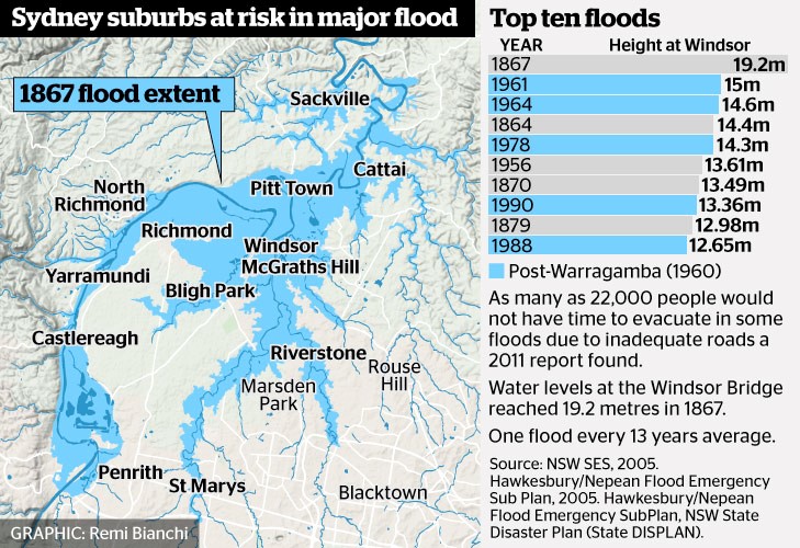 The benchmark for flood risk often used is the worst recorded flood that occurred in 1867 when the water height at Windsor Bridge was 19.2 m. This figure (from Sydney Morning Herald) provides data of past major floods and the flood extent in 1867.
According to the State Emergency Service, the estimated rainfall in 1867 in the lead up to the flood was 770 mm over three days averaged over the entire Nepean River catchment. The flood experience would be different now because several dams have been built in the Nepean catchment.
Government Proposals for Flood Mitigation
The high rainfall experienced in 2013 led to the need to release water causing minor flooding. The NSW government initiated another Hawkesbury Nepean Flood Management Review.
The review concluded that there is no simple solution or single infrastructure option that can address all of the flood risk in the Hawkesbury Nepean Valley floodplain. The risk will continue to increase with population growth. Evacuation is the only mitigation measure that can guarantee to reduce risk to life. According to the State Emergency Service a flood at the 1867 level would now lead to the evacuation of 90,000 people, damage to 12,000 homes and a cost of $5 billion.
As Prof Paul Boon explained during his STEP talk on 11 July on the Hawkesbury River, the topography of the river valley creates several challenges in understanding and managing flood risk.
The Hawkesbury has two main sources, the huge catchment of rivers that flow into Warragamba Dam that has its own flood plain from Emu Plains to Castlereagh. Then the Hawkesbury starts at Yarramundi when water sourced from the Grose Valley catchment in the Blue Mountains joins the Nepean. There is a flood plain around Richmond and Windsor through to Cattai but then more rivers join in and the valley narrows again with steep sandstone gorges and many twists and turns. This means that floods can bank up and spread out over broad areas of western Sydney.
Recommendations of the Review
Some points from the first review report are:
- Due to time constraints the review only assessed the flood mitigation potential of raising of the Warragamba Dam wall crest by 15 and 23 m. Pre-feasibility construction costs and reduction of flood levels have been calculated. However, economic, environmental and social costs and benefits have not been included at this stage. Detailed cost benefit analysis will be conducted for the options for the raising of Warragamba Dam in Stage 2 of the review.
- The review also assessed the potential for changing the operation of Warragamba Dam at its current configuration to provide for flood mitigation. Options examined different ways to create airspace to capture a portion of incoming floodwaters, by reducing the full supply level of the dam, ‘pre-releasing’ water if major flood inflow are expected based on forecast rainfall, or ‘surcharging’ the dam level during floods using the dam’s gates.
- The review concluded that only minor floods, below levels where significant damages occur, could be mitigated using the current dam unless its role as the main water supply to Sydney was compromised. It was also concluded that ‘pre-releasing’ of water from the dam prior to a flood was limited due to the inaccuracies in rainfall forecasts beyond three days, and the potential to increase or prolong downstream flooding.
- Reducing the full supply level of Warragamba Dam provides only a reduction in minor flooding and needs to be assessed against the impacts on Sydney’s water supply. The review considered lowering the full storage level by 2, 5 and 12 m, and concluded that the 2 m lowering had minimal flood mitigation benefits, and the
12 m lowering would have significant impacts on Sydney’s water supply. - Stage 2 of the review will further analyse surcharging the gates and reducing the full supply level for the mitigation of smaller floods, including the operational risks and the impact on Sydney’s water supply.
Even though Stage 2 of the review has not been completed, WaterNSW has been preparing environmental impact statements based on a proposal to raise the dam wall by 14 m and made a referral under the Federal Environment Protection and Biodiversity Conservation Act on specific matters of national environmental significance.
The intended operation after the spillway wall is raised is for water to be held back during a heavy rainfall event and then released slowly in the following weeks. This will provide additional time for evacuation and reduce the downstream flood peak. The stated intention is not to increase the current overall water storage level.
Environmental Impacts
 The Colong Foundation for Wilderness has expressed serious concerns about the impact of the current proposals. The fundamental points made in their Colong Bulletin (July 2017) are:
- Raising the dam level does not deal with the flood waters coming from the major rivers further downstream such as the Grose, Macdonald and Colo.
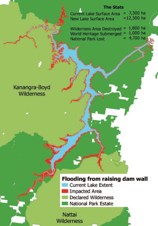
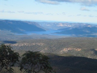
- The extra water storage is intended to be temporary but the vegetation around Lake Burragorang and its tributaries that will, nevertheless, be flooded for several weeks will die leaving ugly scaring of the banks. The upstream flooding will impact the Kedumba and Colong River valleys that are part of the World Heritage listed wilderness areas. A further 1800 hectares could be flooded and another 33 km of rivers inundated.
- The backed up water in the Kedumba River will be visible from Echo Point, the iconic lookout in the Blue Mountains at Katoomba. The figure illustrates the projected increase in areas affected by inundation.
- Even flooding from a 1 in 50 year flood will extend 5 km into the Kedumba Valley and cause the death of 40% of the critically endangered Camden White Gum Forest. This species is listed as vulnerable under the Threatened Species Conservation Act. The Department of the Environment includes the forest in the Kedumba Valley as part of the Save Our Species biodiversity restoration program with an objective ‘to secure the species in the wild for 100 years and maintain its conservation status under the TSC Act’. Methinks WaterNSW should talk to the Department of the Environment.
- Aboriginal cultural heritage will be destroyed.
- Classic bushwalking areas will be lost, historic campsites drowned and access restricted. Bushwalkers are drawn to the pristine Kowmung River, a wild river that has inspired generations of walkers.
Can the Water Storage Level be Managed Instead?
Assoc Prof Stuart Khan, an expert in water engineering, disagrees with the need to raise the dam level. Management of the water level by controlled releases is a safer option so that the dam is never full. The desalination plant that can supply 15% of Sydney’s water needs, could be put to use when the need arises by way of earlier releases. Basically he disagrees with the review’s conclusions.
This is a fascinating risk management problem. Should we:
- reduce the water level if a period of heavy rainfall is projected and thereby reduce the water supply capacity with the backup of the desalination plant; or
- increase the dam wall at great expense and environmental damage that would threaten the tourism industry but still not eliminate the flood risk
Whatever option is taken flood risk cannot be eliminated. However the government is still going ahead with allowing massive population increase in the flood plains of the Hawkesbury Nepean system. As population grows the warning time needed to organise evacuation will increase.
Given the improvement in longer term weather forecasting. The government must explore options for smarter use of risk management techniques to adjust the storage levels. Raising the dam wall ignores this potential and could be a waste of $700 million.
Also future governments could easily be tempted to use the raised dam wall to increase water storage permanently to provide water supply for Sydney’s projected massive increase in population.
Other Serious Water Management Issues
As reported in the Sydney Morning Herald on 21 August, coal mining is impacting on the Sydney water supply catchments but the government is not carrying out adequate monitoring.
The 2016 Audit of the Sydney Drinking Water Catchment was tabled in parliament on the quiet. The National Parks Association discovered the report. It revealed that groundwater losses from longwall mining under the catchments in the Woronora areas has not been quantified. This is despite mining company reports have indicated that about 25 to 40 million litres a day have been entering the mines.
The 2013 audit report revealed that research was underway into the connectivity of surface and groundwater but no results have been revealed in the 2016 audit. This is not good enough given that these mining companies are still applying to expand their mining operations under the catchment.
There are also problems with coal mines leaking toxic chemicals into catchment rivers. Examples are the Springvale mine that has been pumping untreated waste into the Coxs River and the closed Berrima mine that has been leaking pollutants into the Wingecarribee River.
Flooding Wilderness, Wild Rivers and World Heritage
Two weeks before the Federal election with Warragamba Dam threatening to spill due to severe storms, the Baird government committed to raising the dam wall to prevent potential flood impacts on marginally held seats in western Sydney. Perhaps for the same reason, NSW Labor reversed its ‘don’t raise the dam’ position and supported the proposal. However, no new information was released to justify this decision. The economic case and environmental impact statement for such a major project are years away, so it seems to be another case of decision now, judgement later for NSW.
This is not a new proposal. A similar scheme was defeated in 1995 following a strong campaign by the Kowmung Committee led by Andrew Cox, after the Greiner–Fahey government had committed to raising the wall in 1993. The subsequent Carr government then approved construction of a large spillway beside the dam, completed in 2002, to protect it from major floods.
In December 2012 the NSW government accepted a recommendation from Infrastructure NSW in its 20 year State Infrastructure Strategy:
to review all major flood mitigation options available, including raising the Warragamba Dam wall, to significantly reduce the potential economic and social impact of flooding in the Hawkesbury Nepean Valley
This report was overseen by chief executive officer, and former Sydney Water head, Paul Broad, and ex-premier and chairperson of Infrastructure NSW, Nick Greiner. To them the dam was unfinished business.
Raising Warragamba Dam’s wall will inundate over 3,000 hectares of World Heritage listed national park lands, wilderness and wild rivers. Lower reaches of protected wild rivers, including the Kowmung, Coxs and Nattai Rivers, will be flooded. Temporary inundation caused by the proposal will scar wilderness areas, kill riverbank vegetation and deposit sediment. The affected parts of the southern Blue Mountains national parks, arguably the most protected parks in Australia, may have to be revoked, as they will be degraded if this scheme proceeds.
Temporary impoundment of floodwater will result in the ‘bath-ring effect’ – visual scarring of the landscape when natural areas are temporarily inundated. The NSW government would like us to believe that the drowned World Heritage Area will not be degraded, but once native vegetation is inundated and smothered in sediment, it becomes replaced by an eroding mess of bare earth and weeds.
 Views from McMahons Lookout, Splendour Rock, Burragorang Lookout and many others in the Blue Breaks will be ghastly. Lake Burragorang will have a much expanded ‘bath-ring’ and may also gain an enlarged Schedule One area further up the Coxs River, interfering with Katoomba to Kanangra walks, spoiling or placing off limits favoured campsites.
The Camden White Gum forests in the Kedumba Valley, listed as vulnerable under Commonwealth environment laws, will also be lost when flooded.
The Blue Mountains Conservation Society is opposed to the development. Vice-president Tara Cameron said:
We are very concerned that between Badgerys Creek airport and raising the Warragamba Dam wall, the world heritage values of the Blue Mountains will be deemed at risk by UNESCO. Australia has an international obligation to protect these areas not destroy them. This is an environmental disaster
(BM Gazette, 20 June 2016).
Developer Benefits
Former National Parks Association CEO, Andrew Cox, now with 4Nature, believes that the proposal may put more people at risk of flooding, not less. ‘We’re worried that by raising the dam and providing some level of protection it will actually trigger development on the flood plain,’ Mr Cox said.
Western Sydney Leadership Council chairman, Christopher Brown, has already flagged developing flood-prone land as a potential funding source for the dam wall extension.
‘I think there’s the capacity to use a value-capture funding method to reduce the impact on taxpayers,’ he said.
‘Maybe via a levy on land release that was previously considered flood-prone so we might be able to do it at a cheaper rate than what the government’s talking about.’ He suggested the wall extension could potentially be made higher than 14 m if such a levy was charged (Sarah Gerathy, ABC News, 17 June 2016).
Removing planning restrictions to develop flood prone areas will be highly profitable for some, but will endanger lives. In fact much of the North West Growth Centre around Riverstone is significantly affected by flood prone land. Residential areas are nevertheless planned within the maximum possible flood zone despite the acknowledgement that the enlarged dam will have no effect on extreme floods.
Flooding associated with the Upper Nepean which recently inundated Picton, as well as floods coming down the Grose, Colo and Macdonald rivers are not mitigated by the proposed dam wall raising.
Solutions
The best way to reduce the impacts of flooding on people is to relocate low-lying homes and avoid further building in flood prone areas. Floodplains are for floods and the proposed higher dam wall does not alter that fact.
Given Sydney Water’s new capacity to access water from the lower levels of Warragamba Dam, and the water security provided by the desalination plant, a less damaging solution would be to reduce the dam’s full storage level by a third and allow that proportion to be used for flood storage. The dam’s hydroelectric plant could be refurbished and then operate to lower the stored water to desired levels following a flood, while generating electricity for the national grid.
Efficient use of existing dam capacity, along with better flood planning and emergency response will save lives and the World Heritage area from an unnecessary $700 million dollar dam project and its contingent real estate development boom on the floodplain.
This article was written by Keith Muir. It was originally published in the Colong Foundation for Wilderness Bulletin, August 2016 edition. Reprinted with permission.