
Displaying items by tag: maps
STEP History – A Mapping Retrospective
The preparation of STEP’s history by Graeme Aplin and the committee is progressing well and will be completed by our 40th anniversary celebration on 22 July. This has given us an opportunity to reflect on the work that went into the development of our walking maps and the tremendous contribution of our volunteers. Below is an outline of the history and process of production of our maps.
There is still a regular demand for the STEP maps. Their broad coverage and detail make it possible to plan connections with public transport and interesting variations on the standard routes.
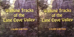
First Lane Cove Valley Map
It all started in the 1980s when a group of South Turramurra locals decided that a map was needed of the STEP Track and other local tracks. They went out checking the tracks that had been created over the years by various authorities and locals who found their own way to explore the bush. There was no national park in those days. They often met people who welcomed the idea of formal printed map. So this was the beginnings of the first Lane Cove Valley map that was printed in 1990 but it had a long gestation period of about 8 years.
The first draft was developed by geographer, Graeme Aplin and then Margaret Booth and the team of South Turramurra locals marked out the tracks which were then verified by a team of volunteers. This map covered the area upstream from De Burghs Bridge.
The final cartography and printing was done by the Central Mapping Authority in Bathurst and the Paddy Pallin Foundation provided a loan to cover printing costs.
The map was launched by Tim Moore, the State Minister for the Environment as a prelude to a bushwalk on 19 August 1990.
2000 and 2016 Lane Cove Valley Maps
In late 1997 the committee decided that a revision was needed because most copies had been sold, and changes had been caused by the 1994 bushfires and the M2 motorway. This time the map was extended to cover the whole Lane Cove River valley down to Greenwich Point. The map was launched in November 2000 by Peter Duncan, Director of the Centennial Park and Moore Park Trust.
John Martyn’s experience as a geologist was vital for the creation of the base map. Many hours or work were involved in building a full-colour base map stitched together from digital files provided by the NSW Lands and Property Information, air photos, satellite images and field observations. Roads, national park boundaries, local parks, hazards, natural features and many other details were meticulously inserted. Then the tracks were added and checked by John and a team of volunteers. Some volunteers did this with GPS and for wider tracks by Google Earth and air photos, others by simple navigation.
By 2015 it was realised that the map was getting out of date again. We had a good base to work on with the previous map. However John decided to extend the map detail to the west and south-west to cover more of the Lane Cove River catchment and more opportunities for walking connections with railway stations on the northern line. It is amazing how much has changed over 15 years so this again was a major exercise. Often it is harder to check for changes than to start from scratch!
It would not be possible to produce both maps without the help of our volunteers. Their work is much appreciated. Their names are listed below but please excuse us if any names are left out as it was hard to keep track of them all:
- 2000 map – Phil Helmore, Ralph Pridmore, Jenny Schwarz, Peter and Robin Tuft, Natalie Wood, Helen Wortham.
- 2016 map – John Booth, Debbie Byers, Robert Carruthers, Jill Green, John Hungerford, Adrienne Kinna, Andrew Lumsden, Ruaridh MacDonald, Natalie Maguire, Alan McPhail, Ralph Pridmore, Jim Wells, Natalie Wood, Ted Woodley.
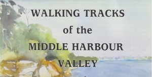
Middle Harbour Maps
It became evident in the early 2000s that the Middle Harbour catchment offered numerous walks over a much larger area, and also that many STEP members who are keen walkers also lived in or near that catchment. Given the experience with Lane Cove mapping it seemed an easy choice to create bushwalking maps of that area. It also followed creation of Garigal National Park which merged large council bushland areas into one entity. The map coverage included a considerable area of suburbs carrying small reserves and linking larger bushland reserves, and included popular harbourside walks too, many in Sydney Harbour National Park. The end result was two double-sided sheets extending from Mona Vale Road to Greenwich and North Head.
The base for the Middle Harbour catchment was purchased from Lands and Surveys digital database and they also carried out the printing.
Volunteers were John Balint, Therese Carew, Bill Filson, Tim Gastineau-Hills, Gerald Holder, Simon and Joy Jackson, Bill Jones, Jan Kaufman, Kate Read, Jennifer Schwarz, Peter Tuft and Natalie Wood. STEP was also supported by the late Bill Orme, Graham Spindler and Leigh Shearer-Herriot (North Sydney Volunteer Walkers Group), NPWS and the relevant councils. Map cover pictures were watercolours by artist Janet Carter of East Roseville.
Paper Maps are Good Friends
Robin Buchanan reminds us that maps on smart phones have limitations.
‘Just another lost bushwalker’ said the weary voice of the policeman at Hornsby Police Station when I rang to ask why there was a helicopter searching the bush below our house. For those who know the areas of Lane Cove, Berowra and Ku-ring-gai National Parks well it is hard to imagine becoming lost but it happens very regularly and even more so in larger national parks.
Too many people rely on smart phones. These are really useful but they have three disadvantages. They run out of batteries quickly if they are used for navigation for too long, they don’t show landform and they can’t give both a detailed view of where you are at the same time as giving a broad view of the area. Hand held GPS (global positioning system) units are better as they are more rugged; the batteries are only used for the GPS and are easily replaced. They also have designated maps installed but they still suffer the same problem as phones when you zoom in and out.
Paper maps never run out of batteries and you can simultaneously see where you are and where you are going – even if it is several kilometres away. These days I tend to take a phone, GPS and paper map with me at all times as experience has taught me that they all may come in useful. The following examples illustrate how useful maps can be.
We were on a track a friend had walked many years ago but as the sun slid down in the west the track became more and more overgrown and our speed became slower and slower. The GPS told us exactly where we were but the paper map was spread out so we could accurately gauge the distance if we went back, continued on or crossed the valley to a well-established tack. It quickly became clear that forward and backwards would see us out after dark but we should make it if we crossed the valley.
On another occasion a friend decided to walk ahead but missed the turnoff to the cars. No friend when we got there! The map was spread out and his most likely positions determined. The hunt was begun. He was quickly located at one of the points and all ended happily.
I have even given away a map when it was obvious that walkers had no idea of the size of the area in which they were walking: some simple calculations were done; if it has taken x amount of time to walk as far as you have, then to reach Berowra Creek and back is going to take four times as long. That will be after dark. Why not go to a nice lookout instead? Here, have a map.
Groups can gather around a map, make collective decisions, name far mountain ranges and reminisce about walks they have done before or plan the next walk. Good group dynamics.
1:25 000 Maps
The maps that give the largest view of an area are the 1:25 000 series (every distance on the ground is divided by 25 000). These are published by the NSW Government.
Bobbin Head Information Centre in Ku-ring-gai Chase usually have stock of the maps covering local national parks.
Don’t be put off by the name of the maps; they are titled by a main feature on the map. The Hornsby map is not a map of Hornsby, Hornsby is located in the centre of the map and lots of bushland is shown on the map as well. The local national parks are covered by several maps:
- Ku-ring-gai Chase: Hornsby, Cowan, Mona Vale and Broken Bay
- Berowra Valley: Hornsby and Cowan
- Lane Cove: Hornsby and Parramatta River
- Garigal: Hornsby,Parramatta River and Mona Vale
STEP and Friends of Berowra Valley
STEP’s three maps cover the Lane Cove Valley and Middle Harbour (North and South) and are printed at 1:10 000 (ground distances divided by only 10 000). They give a more detailed view of the area but are still broad enough to give you a good view of your surroundings.
The Walking Guide to Berowra Valley National Park published by the Friends of Berowra Valley is printed at a scale of approximately 1:18 000.
WildWalks
WildWalks produces detailed maps and descriptions of particular walks. You can download pdfs but printing them is safest. They are best used in conjunction with maps of the area such as the ones described above.
Great North Walk
The Great North Walk, through Lane Cove Valley and Berowra Valley is covered by The Great North Walk Companion.
Having Trouble Reading Maps?
If you have trouble reading paper maps and would like an introductory course, please let us know! Don’t be ‘just another lost bushwalker’.