
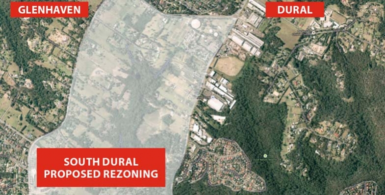
South Dural Residents and Ratepayers Group, a developer initiated lobby group, has made numerous applications since 1990 to Hornsby Council for the rezoning of 240 ha of rural lands in south Dural for urban purposes. The latest attempt is currently under consideration. Click here for details of the history of the lobbying
In the latest attempt, consultants’ reports have been commissioned as part of the first step of the application, that is, to change the zoning from rural to various levels of residential density and recreational zoning. Submissions closed on 2 December.
The spine of the proposed development is an area of bushland along Georges Creek and another unnamed tributary of Berowra Creek. Indeed the developer is touting the natural views and the tall forest as a feature that will allow six storey apartments to fit into an ‘eco-friendly’ community. All in all the proposal is for 2,900 dwellings that could house 9,000 people.
The bushland is of high conservation value with areas of Blue Gum High Forest (10.5 ha), Sydney Turpentine Ironbark Forest (22 ha), Blackbutt Gully Forest (30 ha) and Shale Sandstone Transition Forest (1.4 ha). The first two listed are classified as critically endangered ecological communities under the federal Environment Protection and Biodiversity Conservation Act.
As the opposing residents’ group, the Galston Area Residents Association, points out there are many reasons to oppose the application, for example:
- it is inconsistent with the metropolitan plan to preserve remaining rural land
- current roads cannot cope with current traffic let alone that generated by the extra residents
- public transport is inadequate and the north west rail line is a long way away so buses will have to operate on clogged roads
- there is insufficient provision for schools, shops, recreation areas and other basic infrastructure
STEP opposes the rezoning application for three main reasons:
1. Inadequate vegetation data and mapping
The bushland area comprises about 64 ha, a quarter of the site. As large parts of the land are privately owned it has not been possible to carry out on the ground vegetation mapping. This applies in particular to the area of Blue Gum High Forest of about 10 ha. This is in the context of the total area of Blue Gum High Forest remaining in Sydney of less than 200 ha. Other areas of significant vegetation have not been sampled adequately or consistently.
It is totally unsatisfactory to be asking the public to comment on such inadequate information, especially when dealing with endangered ecological communities.
2. The proposed zoning map does not reflect the described development or the stated purpose to conserve native vegetation
The higher density six storey buildings are planned to be built closest to the bushland but they are zoned R3 (medium density). It should be zoned R4, high density residential.
There are also inconsistencies in the minimum lot sizes of 125 m2 and 225 m2 stated in different parts of the proposal documents. The prospect of lot sizes of 125 m2 is alarming! No room for trees.
Most of the riparian areas are described as having high conservation significance so should be zoned as E2. However the proposed zoning is RE1. It appears the intention is to allow a gravity feed sewer to be installed along the creek lines, hardly compatible with conservation. Construction of a sewer would need road access that would damage the natural creek line and, on past experience, create a wide band of weed invasion.
3. Large areas of the zoning proposal are deferred
The deferred areas are the main bushland strips that interface between the residential areas and the core riparian areas. They cover a significant part of the bushland. The reason given is the uncertainty of the biodiversity legislation that had not been passed when the proposal was submitted.
These deferred areas will be hard to manage because of the proximity to the housing development so government agencies will probably not want them.
An absolute tragedy would occur if they were traded for biobanking sites elsewhere as it would be impossible to find equivalent vegetation communities to be restored to offset the losses. They should become areas that are off-limits to biobanking.
The effect of this proposal on the existing vegetation will be very damaging unless very detailed precinct plans to protect it are drawn up and very active and expensive management takes place in perpetuity.
It is unsatisfactory to expect the public to comment on this proposal with incomplete and inadequate information.
Summary
Ideally STEP would like this parcel of land to remain rural, but in the event of it being rezoned for residential development STEP would like the potential impact on biodiversity reduced. Possible mechanisms for this include:
- The RE1 zoning changed to E2 to allow better management of the biodiversity values
- The deferred areas to be zoned E2
- The areas zoned E2 to be managed by the local council with the provision of funding for long-term management from the developer
- The area currently proposed for R3 (medium density) should be greatly reduced with a zoning of R2 (low density) in areas with scattered trees
- Very limited R4 (high density) set well back from the bushland
- The minimum lot size for dwelling houses and semi-detached houses increased well above 225 m2, preferably up to 500 m2
- Find an alternative to gravity-fed sewers down the creeks
- Development set further back from the areas of biodiversity constraints so that the bushland edges are not as severely impacted
- Provision of buffering by revegetation should be considered along bushland edges