
Displaying items by tag: development
Prospects for better fauna protection on development sites
In October, at NSW’s Local Government Annual Conference, a motion calling for better protection of wildlife on development sites was passed unanimously. The government now has to agree to implement standards to ensure that native wildlife found on development sites are given a chance of survival. We have standards for occupational health and safety, contamination and waste management so why not caring for wildlife?
Currently an approved Fauna Management Plan is required before a development can proceed but the quality can vary. The plan explains how wildlife that is found should be handled. They are dependent on the experience of the ecologist writing the report along with the developer expectations.
Poor plans are becoming more prevalent as there is more development of greenfield sites and densification of suburbs with canopy cover and flora and fauna corridors. Some plans even provide for injured animals to be euthanised on site. Often wildlife carers have to perform rescues as animals try to escape or are injured.
It all started at the Mirvac site in West Pennant Hills and the fact that they were removing thousands of trees but the planning documents had very few provisions made for protecting the wildlife living in them. There were no requirements to check whether nests, hollows or burrows were occupied and then relocate the birds, possums, echidnas or wombats. It’s the same across all development sites and yet wildlife carers have to follow very stringent codes of practice for any of their interactions with wildlife. Plus all native wildlife in NSW is protected by law – so the question asked by the local community was, where are these protections? And what is happening that they are not being applied?
The issue was raised by some local Hills Shire councillors but the proposal for a motion was defeated by the liberal-dominated council. So the group turned to Hornsby Council. After much discussion between many councillors, community members, journalists, vets, wildlife carers and a lot of persistence Hornsby Council councillors agreed to present this motion before the conference in August.
As Cr Salitra said in presenting her motion to Hornsby Council:
Legislating standards for wildlife on development sites will provide certainty for all stakeholders – the developer, ecologists, tradespeople, wildlife carers and our community. Certainty in procedure will provide clarity on who and what these standards apply to for all stakeholders in a currently grey area. And they will result in more efficiency on development sites, where these repeatable actions become the norm.
Why has it taken so long to implement these standards?
Mirvac development – who ‘owns’ the forest?
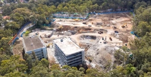
The Mirvac development of the former IBM business park at West Pennant Hills is proceeding. In September 2021 the application to demolish the existing buildings and remove 1,253 trees was approved. This has now been completed despite a lot of community concern about the disturbance to wildlife during the spring breeding season.
In October 2022 Mirvac’s Concept Development Applications for the next stage of the project came before the Sydney City Central Planning Panel. This involved the technicalities of subdividing the land into sections relating to the various types of building – 252 apartments and 165 medium density houses. Plus the removal of another 1,877 trees. There were many objections to the application for a height variation but the Hills Council had no objection to the apartment buildings being eight storeys instead of the LEP standard of six storeys.
So the concept DA has been approved. The only amendments to the conditions of consent related to protection of the Powerful Owls that have a nest site close to development footprint, use of wildlife friendly fencing and fauna sensitive lighting.
Forest in Danger found a big surprise in the documents submitted with the DAs. The future of the 10.3 ha of high quality forest containing critically endangered Blue Gum High Forest and Sydney Turpentine Ironbark Forest has been the subject of much controversy. The community believed they had a victory when Mirvac agreed to a Voluntary Planning Agreement dedicating the land to Forestry Corporation NSW so it could be managed as part of the Cumberland State Forest next door. This dedication of the land, defined as the Forest Dedication Land, was believed to be a condition of consent to be approved by the Panel.
Low and behold when the documents were submitted with the DA it was found that the Voluntary Planning Agreement dedicated ownership of the land to the minister for planning and would be only ‘managed’ by Forestry Corporation NSW. Not only that, Mirvac could request that the minister approve a change to the boundaries, and that the minister could approve or refuse the request at their absolute discretion and also request a change. So this land is no longer conserved in perpetuity. It appears that Mirvac can sell off some of the Forest Dedication Land. Forest in Danger has sent an objection.
Development plans for the Lourdes Retirement Village should be refused
The owner of Lourdes Retirement Village at the end of Stanhope Road in Killara have been trying for several years to do a major redevelopment of the site. The Friends of Ku-ring-gai environment (FOKE) have been monitoring the process for some time and, as reported on their Facebook page, the local state MP, Jonathan O’Dea has spoken in parliament expressing many concerns.
Approval of a development like this would establish a very bad precedent of high rise buildings in a low density residential area on a ridge top intruding deep into a bushland setting.
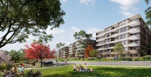
Lourdes Village is on 5.25 ha on the edge of steep bushland in Garigal National Park. It currently has 108 independent units, an 83-bed aged care home and 49 serviced apartments. The owner, Stockland, is proposing to rebuild the entire complex and increase dwellings to 141 independent units, 110-bed aged care home. Sixty-three medium density townhouses would also be built on the southern and eastern part of the site. The nature of the village will be changed from a focus on senior’s accommodation to a more general residential complex. Other planned features include landscaping works, 1400 m2 of communal space, new internal roadways, a community centre, swimming pool, a pavilion for outdoor functions and 398 car parking spots.
This sounds all very good as a place to live but what about the bushfire risk of being on the edge of the bush and the impact buildings 22 m high with a high number of residents will have in this location surrounded by low density housing?
The proposal would result in the population of the site rising from about 275 to 546 people, but with only a small increase in the number of beds for the aged. There is only one residential road into the area that ends in a cul-de-sac.
The proposal could only proceed if Ku-ring-gai Council’s local environment plan is amended to accept the proponent’s intention to greatly increase the nature of the ‘village’, namely:
- change the zoning from low-density to medium‑density residential (R2 to R3)
- change the maximum height of the buildings from 9.5 m (the usual R3 limit) to 22 m to allow for up to six or seven-storey residential flat buildings
- double the floor space ratio controls from 0.3 to 1 to 0.75 to 1 so that 389 car parking spaces can be incorporated
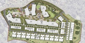
An illustrative master plan is shown below (source: Plus Architecture)
In recent years the Village has been rundown with units whose residents have left or died remaining vacant. This has contributed to the destruction of a sense of community for the remaining residents. The maintenance of some buildings and services has also been eroded since an earlier Stockland development attempt in 2018 was comprehensively rejected, including by Ku-ring-gai Council and the NSW Rural Fire Service.
Since the plan was submitted Stockland has sold all its retirement village developments to a private equity company, Levande which has taken over the development at Lourdes.
Local residents are strongly opposed as it is out of character with the surrounding low density housing. It will generate additional traffic onto a dead end street. Evacuation of residents in the case of a bushfire would be difficult.
Ku-ring-gai Council is opposed to this proposal as it has been to previous plans for reasons of bushfire risk and the inappropriate location for this type of development.
Next stage of the planning process
The proposal has been submitted as a Gateway proposal to the Department of Planning. It was assessed by the Sydney North Planning Panel and was accepted in July 2022. A period has been set for further submissions from the public (now closed) and some additional reports were requested by the panel. It is now before the Minister for Planning for final Gateway approval that could allow it to go to the development application stage.
Bushfire risks
One concerning aspect relates to the confirmation in the documents provided by the proponent that the bushfire protection standards will be met even though the risks of the site are rated in the highest category. They commissioned from Blackash Bushfire Consulting, a report that misrepresented RFS' current position as ‘endorsement’ of the rezoning. In fact, the RFS did not give approval but said analysis of the risks could be deferred to the next stage when more detail would be available about the building designs.
The assessment has to take into account the difficulties of evacuating the large number of aged residents. Statements have been made to the effect that the townhouses on the southern side will act as a shield against fire. Great protection for those residents living in these dwellings! The plans refer to shelters being provided within the site.
Ku-ring-gai Council has written a scathing submission to the planning panel. They are concerned a development like this will create the wrong precedent for this type of development to be accepted in a location like this. They commissioned an independent assessment of the bushfire risks.
The main conclusions made by council in their submission are:
- The proposal fails to demonstrate protections to the proposed increased population on the site, including vulnerable elderly, in an environment of changing climate patterns and the expected increased incidence and severity of fire related events.
- The exhibited bush fire report attached to the planning proposal contains no detail to substantiate the claims of safety to citizens.
- The planning proposal fails to provide transparent exhibited bushfire related evidence to warrant the departure from key strategic considerations that are applied to all other sites across the LGA and NSW and that, if approved, would set precedents detrimental to key work related to bushfire safety.
- Detailed design evidence pertaining to bushfire aspects cannot be deferred to the development application stage, it is required at this planning proposal master plan stage to determine if the increased dwellings and population on the site is warranted or not.
As Jonathan O’Dea said in the speech to state parliament:
I am seriously concerned that the proper planning and assessment process is at risk of being subverted for this site. Approval is not in the public interest, and I urge the new owners to rethink their plans. In any event, I believe the Minister for Planning should stop the planning proposal at Gateway.
Final chapter of SAN development
The Wahroonga Estate was acquired by the Seventh-day Adventist Church in 1898 when the land was just an orchard. The land was then developed by the Seventh-day Adventist Church with the hospital, church and administration buildings.
A major redevelopment was planned in 2008. Plans have now been submitted to Ku-ring-gai Council for the final stage of this development on the San Hospital site. The concept plan for the developments was approved in 2010 by the Department of Planning under the controversial Part 3A process under the Environmental Planning and Assessment Act that took consultation out of the hands of councils and the community. Nevertheless, the plan ended up being significantly smaller than the original application submitted in early 2007.
STEP, the local community and local councils strongly opposed the plans. The department ruled that several reports submitted by the developer engaged by the SAN were inadequate.
The final stage covers the construction of four apartment buildings, one on Fox Valley Road and three behind the school with an access road from Fox Valley Road with traffic lights.
The design is for 178 apartments with 222 car parking spaces plus visitor parking. The approved plan was for 200 apartments in five buildings but, following Adventist school and local community consultation, more open space was allocated for use by the school.
A new set of traffic lights will be built near the entrance to the school and apartment complex. This is only a couple of hundred metres from the traffic lights at the entry to the hospital. Despite the claims that the new development will not worsen the current congestion this seems implausible.
Biodiversity management plan
During the prolonged approval process it was found that the ecological reports commissioned by the developer Johnston Property Group were seriously inadequate.
Ku-ring-gai Council vegetation mapping showed that proposed new housing on the eastern side of Fox Valley Road and creation of a new road would have destroyed one of the finest examples of vegetation transition from shale to sandstone soils. Also the vegetation mapping of the whole site confirmed that there were significant areas of critically endangered Sydney Turpentine Ironbark Forest and Blue Gum High Forest. The integrity of these areas would have been damaged by asset protection zone requirements.
When the mapping was corrected the areas of STIF and BGHF were sufficient to alert the federal Department of Environment (whatever it was called at the time – see note) of the potential damage to these critically endangered ecological communities under the Environment Protection and Biodiversity Conservation Act. The department ruled that the development was indeed a significant risk and made the development a ‘controlled action’. This means that the biodiversity management is subject to regular review and is detailed in a biodiversity management plan.
In the end the reduction in the residential development areas increased the bushland area from 18 ha to 34.1 ha, all zoned as E2, environmental conservation. The Adventist Church is responsible for implementation of the biodiversity management plan. A volunteer group called Wahroonga Waterways Landcare group managed by Adventist Aged Care also assists.
There is a huge amount of work to be done to restore the areas that were neglected for many years. However, the area along Coups Creek is magnificent bushland and is open to the public to enjoy. The area on the eastern side of Fox Valley Road is more problematic as a large part of it was reserved as a corridor for the freeway linking the F3 and M2 that was finally abandoned in 1995 (see Coalition Against the Lane Cove Valley Freeway 1988 to 1995: An Amazing Community Achievement. Some of this land is still owned by the NSW Department of Planning that doesn’t appear to be taking any action to control weeds like lantana and ochna.
Note on names of Australian government environment department
2010–16, Department of Environment, Water, Heritage and Arts
2016–20, Department of Environment and Energy
2020 to present, Department of Agriculture, Water and the Environment
Peat Island development proposal at odds with Hawkesbury landscape
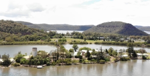
As one drives north along the M1 towards Gosford and cross the Hawkesbury River Bridge one has magnificent views of the river and the dense bushland on the surrounding hillsides.
Heading south there is a spectacular view of the sandstone cliffs created by the river and the cuttings that were made to build the freeway that now allows easy access from the Central Coast to the metropolis of Sydney.
To the east there are two islands, Long and Spectacle. The natural values of the whole area are preserved as all these lands are national parks or nature reserves. The only development is low key with some houses clinging to the water’s edge or on available flat land such as in Brooklyn, Mooney Mooney and Dangar Island.
There is one area of development that has stood untouched for many years on Peat Island. This island originally housed a centre for treatment of alcoholics that was opened in 1910. It was later a general psychiatric hospital and a residential care centre for people with intellectual disabilities. It was closed in 2010 in line with the government policy to close down large institutional care centres. There are many historic buildings on Peat Island plus a chapel on the east side of the M1.
The nearby lands are the only flat areas available on the Lower Hawkesbury for community use. They provide access and views for the Lower Hawkesbury. In addition, the area contains many sites of cultural, heritage and spiritual significance to Indigenous and non-indigenous Australians.
The NSW government has been trying to sell off the land on Peat Island and on the narrow peninsula adjoining it near the M1 and Pacific Highway. In 2014 they proposed the development of 450 houses, mostly medium density building plus retail, tourism and community facilities. Fortunately it was knocked it back. It was totally inappropriate to have so much development in an area with no public transport or employment opportunities. The dwellings could end up being mostly holiday houses and make no contribution to housing needs.
The Central Coast Council is currently considering a new concept plan proposal from the Department of Planning. This still has a significant amount of residential development on the land alongside the M1 with 105 houses and townhouses and medium density buildings with up to three stories with 162 apartments.
Peat Island would be transformed into a tourism and accommodation precinct, with supporting cafes, restaurants and the like to be accommodated in retained historic buildings and the addition of new buildings.
The chapel on the eastern side of the M1 has pedestrian access to Peat Island via an underpass. The precinct includes several historic cottages. The plan is to adaptively repurpose these buildings for community use plus the possibility of a community centre. However the whole area would be surrounded by some of the new housing.
There is also a possibility of a marina that Hornsby Council’s submission explains would cause several environmental issues such a damaging the estuarine mangrove environment and disturbing sediment contamination including asbestos.
These issues are apart from the fact that it would be totally out of keeping with the scenic landscape of the Lower Hawkesbury.
Hornsby Council’s submission also points out this level of development in an isolated area will exacerbate existing inadequate water and sewage management and parking facilities and cause traffic congestion.
The local groups opposing the plans are the Central Environment Network and Dyrarubbin Peat Island Association. Their view is that the concept plan lacks the vision and depth expected for an iconic site of regional, state and national significance. Dyarubbin is the First Nations Darug people’s name for the Hawkesbury River.
STEP believes the land should be developed for a world class park as the natural, cultural, heritage, aesthetic, social and recreational values of the site far outweigh the value as a residential area. This park should link the historic buildings and landscape of Peat Island to the broad sweeping landscape west of the M1 and to the intimate space of the chapel precinct. The historic buildings of Peat Island can be sensitively repurposed for cafes, cultural centres, museums, and a marine/ estuarine research centre. The proposed housing in the chapel precinct should be deleted as it severely impacts the curtilage of this building.
Submissions closed just prior to Christmas. We hope that common sense prevails. The NSW government has created some outstanding public parks such as Bicentennial Park at Homebush Bay. This Peat Island Park could be another example.
Last Attempt to Stop the Mirvac Development Plans for the IBM Site
The final deadline was set at 31 May for submissions on the Hills Council’s applications to the NSW government to change the zonings in their local environment plan and insert some special provisions in the development control plan. These changes will facilitate development on the land owned by Mirvac that currently contains the old IBM corporate headquarters on the corner of Coonara Road and Castle Hill Road in West Pennant Hills next to the Cumberland State Forest.
The basic framework of the proposals is unchanged from earlier plans described in STEP Matters (Issue 198). The main purpose of the council application at this stage is to facilitate the development of 600 dwellings. Ancillary aspects are that, if the housing development proceeds, Mirvac will sign a voluntary agreement to allow the existing playing field on the land to become public open space and pay for the development of a soccer field with synthetic turf and the necessary public access road.
The design of the housing development will be subject to further scrutiny at the development application stage but if these current plans are approved, the basic framework will be set in concrete (lots of it!).
Even though part of the site is currently developed as a corporate park, these buildings are surrounded by mature tree plantings. The majority of the site is classified as Blue Gum High Forest or Sydney Turpentine-Ironbark Forest, both critically endangered. This is a unique opportunity to preserve one of the few remaining areas of high quality vegetation and its associated fauna habitat in north-western Sydney. Its proximity to Cumberland State Forest adds to the value of this preservation through its connectivity and boosting of resilience of the vegetation.
Hence STEP is opposed to the whole development proposal.
Future of the forested area
The future management of the large forested area that is to be zoned E2 (environmental conservation) which contains critically endangered ecological communities and fauna, is completely unknown. The development control plan amendment relating to the site refers to the residents as being responsible for the cost of maintenance of the 'significant vegetation'. This is totally unrealistic.
It is essential that a stewardship or conservation agreement be established defining responsibilities and funding of management together with a vegetation management plan. This should be in place before any dwellings are occupied.
As the E2 land will be for the benefit of the whole local community, not just the residents of the Mirvac developments, it is appropriate that the Hills Council be responsible for its management.
Synthetic playing field
The proposal for the synthetic playing field should not go ahead until the environmental impact of the use of this surface is thoroughly assessed. A detailed analysis is required of the impact on the bushland below the field of:
- stormwater runoff from the hard surface
- runoff of degraded synthetic grass and substrate pieces
- the loss of soil biota under the artificial surface
- the risk from a fire in the surrounding bushland spreading to the field
- conversely, the surface itself is mostly made of rubber and will be much hotter than in the surrounding vegetated areas, so what impact will this have on the bushland and wildlife?
Of course no floodlighting should be allowed so close to bushland that is home to several nocturnal species such as the Powerful Owl and several species of bats.
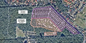
Development plans
The image at the top of the page shows the proposed layout of the development. The medium density housing area (200 dwellings) is along the edges of the site while the high density zone (flats up to six stories) is lower down next to the forested areas.
The main argument from Mirvac in favour of the development is its proximity to the new Cherrybrook Metro Station. Residents will however have to walk up a steep hill and cross Castle Hill Road to get to the station. The shortest possible walk is 800 m. The other side of Castle Hill Road which is in the Hornsby Council area is currently zoned low-density residential that will no doubt be planned for higher density development in the future as the station is now operating.
Overdevelopment
The major reason for objections to the proposals is the level of development. The residents of West Pennant Hills have rallied strongly against the proposals. Over 4,000 objections have been received by the Hills Council. They are concerned about the increase in traffic on already congested roads as well as the environmental impact of the development.
The main point is that the existing IBM corporate park is a valuable asset. The buildings should not be knocked down. With a bit of imagination alternative uses could be found that will not lead to destruction of the mature native vegetation that surrounds the buildings and the car park.
In any case the council and Mirvac have not demonstrated that there is a need for this huge housing area. We note that the Department of Planning document Cherrybrook Structure Plan: Vision for Cherrybrook Station Surrounds (September 2013) does not envisage any residential development on the site. Increases in housing are planned for neighbouring areas north and further west of Castle Hill Road with a total number of new dwellings planned of 3,200 by 2036.
The plan is an example of the notorious spot re-zonings that have plagued development in Sydney. A developer comes up with a plan that is outside the planning guidelines. The local council knocks it back so the developer is able to go directly to the Department of Planning to gain approval via the Gateway Process. The new planning minister, Rob Stokes, has stated that this system will not continue but we will have to see how that can come about.
As Hornsby Council says in their submission:
Any decision for this site should be deferred until a precinct-wide structure plan or strategy is adopted for all the land parcels surrounding the Cherrybrook Metro Station.
...
The proposal by Mirvac to redevelop the subject property for residential purposes is likely to trigger further owner/developer-led spot rezoning applications in the area. This would lead to an ad hoc approach to land use planning for the Metro Station precinct. The process would undermine the planning framework for both councils and lead to poor outcomes for the Cherrybrook community.
Housing plan is overdeveloped
The documents indicating the layout of the medium-density housing precinct show houses that are crammed together, some on blocks as small as 86 m2 that are only 4 m wide. Even with some of the wider lots most of the street will be taken up by driveway access.
There will be little space for street trees. The front and back yards will also be too small for trees to grow with a beneficial canopy.
The design of the subdivision needs to take account of the need for liveability of streets in the face of current heat in summer and expected increases with climate change.
There are also several other concerns about the details of the development and how it will impact on the surrounding forest. These relate to clearing of riparian zones and impingement of asset protection zones into the E2 area and Cumberland State Forest.
We have covered several of these concerns in previous comments on this proposal. They are very concerning but basically STEP is opposed to the development in its entirety.
Conclusion
Mirvac’s website reveals the company’s Biodiversity Policy. The policy states:
At Mirvac, we aim to be an overall positive contributor to environmental sustainability. We firmly believe that responsibly managing our biodiversity impacts will enable us to strategically assess biodiversity-related risks and opportunities and anticipate and respond proactively to emerging regulations and societal expectations.
Mirvac’s plans for the IBM site are clearly not compatible with their Biodiversity Policy.
Bayview Golf Course Developer Trying Again
We recently reported on the application for development on Bayview Golf Course for seniors housing units in an area that is a core wildlife corridor and habitat for several threatened species such as the Powerful Owl and microbats. The development has been strongly opposed by Northern Beaches Council and local residents.
In August the next application for approval went before the Regional Planning Panel. It was resoundingly knocked back basically because it is over-development. The built form would be incompatible with the existing and desired future character of the area. It would have substantial adverse impact on the biodiversity of the area given that it is mapped as high priority biodiversity conservation land in the Pittwater LEP. Bat ecologist Glenn Hoye stated in a submission that subdued lighting would be required and directed to walkway areas but this would be incompatible with OH&S requirement for seniors housing.
This type of development requires a Site Suitability Certificate before further formulation of a proposal can go ahead. This certificate was provided by the Planning Department back in 2017. A freedom of information application has revealed that internal advice within the department recommended against granting the certificate because the type of development proposed was not consistent with the required zoning.
However the developer is trying again by appealing to the Land and Environment Court.
Unfortunately it is too late to send a letter objecting to the development but you can sign the petition and read more about the issue.
Ivanhoe Development: Will there be Genuine Offsets for the Loss of STIF Vegetation?
The amount of development along Epping Road is astronomical. Sure, this development is near the Chatswood to Epping train line and bus services. What happens to people wanting to go north or south? They will add the existing logjam on Lane Cove and Ryde Roads.
More Sydney Turpentine Ironbark Forest (STIF) will be lost How can it be possible to find an offset for the same ecological community?
Ivanhoe Estate which is located on Epping Road between Herring Road and Shrimptons Creek at Macquarie Park is up for mixed tenure high density re-development. At the moment there are 259 social housing dwellings in the locality comprising a mix of townhouse and four storey apartment buildings set around a cul-de-sac street layout amongst mature trees.
It has been that way for 25 or more years but the new proposal provides for 3,500 dwellings (with only 128 allocated to affordable rental housing), basement car parking, a private high school, child care centres, community and retail uses and maximum building heights ranging from 45 to 75 m (20 storeys). This is very clearly an overdevelopment of the site.
Of particular concern is the proposal to remove more than 800 trees from the site including remnant STIF. STIF is classified as an endangered ecological community under NSW and Commonwealth legislation. Currently only 0.5% of the original STIF community remains and every effort must be made to protect and maintain existing remnants intact.
The reason given for this removal is the footprint for the proposed basement parking and an access roadway which means that most of the site will be excavated.
The master plan for the site treats the loss of the STIF as unavoidable and proposes biodiversity offsets in accordance with the NSW Biodiversity Offsets Policy for Major Projects. These offsets are not acceptable because they do nothing to add to the total of remaining STIF. They rely on another remnant of STIF being identified that is not currently protected by zoning or legal agreement and making that site subject to such protections.
Despite the master plan relying on offsets for the loss of STIF, the Biodiversity Offset Strategy provides no information about the location of an offset site or time lines for implementing any offsets. The destruction of this important vegetation can be avoided by changing the master plan. This should be the first priority and must be done. There is ample opportunity to scale back the development and protect the STIF while providing an increase in the number of dwellings available in this increasingly developed area.
With Sydney’s population forecast to reach eight million people there will inevitably be many more similar conflicts between development and biodiversity across our city.
This information has been taken from the Ryde Hunters Hill Flora and Fauna Preservation Society newsletter, Wallumetta (August edition).
Medium Density Housing Code Implemented with some Improvements
The NSW government has finalised the Low Rise Medium Density Housing Code and Design Guide that were the subject of consultation during 2016. This code allows one and two storey dual occupancies, manor houses and terraces to be built using the complying development approval pathway. Unless the type of development is not permitted in a residential zone under a council’s Local Environment Plan (LEP) a single dwelling can be redeveloped into 2, 3 or 4 dwellings depending on the size of the block. Design guidelines will have to be met but councils will not have control on the rate of take up of this opportunity.
The code is due to take effect in July but local concerns about congestion and over-development have become so great that the government was forced to defer implementation in four council areas. The deferral is only for a year however. This applies to Ryde, Lane Cove, Canterbury Bankstown and Northern Beaches but other councils are also asking for a deferral. Many areas of Sydney are struggling to cope with recent heavy development and infrastructure is inadequate. Is the one year deferral enough time to catch up?
Some councils, like Ku-ring-gai, already have provisions in their LEP that prevent this type of development in low density residential zones. Other councils want (and need) to be able to control the location of this infill housing option and are still working on a housing strategy that would define where this new category of development could occur. These are the councils that are asking for a deferral. They have just woken up to the potential consequences.
STEP’s submissions on this new type of complying development criticised the ad hoc nature of the application of the code and the broad implications of converting low density into higher density housing. There could be a huge rush of landowners taking up the opportunity to expand the value of their property. Councils need to able to specify areas where this type of development is not suitable, for example, because it does not fit in with the topography or character of particular areas or there is insufficient transport. At least the NSW government has recognised that councils need more control.
Design Guide Improvements
The Design Guide has been developed in partnership with the Government Architect’s Office, and aims to improve design by addressing layout, landscaping, private open space, light, natural ventilation and privacy.
The Design Guide has been improved by defining minimum standards for greenery on the blocks. The government has finally taken on board the importance of trees and gardens in reducing the heat island effect and improving local amenity. The guide specifies:
- minimum landscaped areas
- retention of trees especially along a boundary except where removal is approved by council
- planting of a tree in the front yard if the street setback is 3 m or more (mature height 5 m) and in the back yard (mature height 8 m)
- minimum soil volume to support the trees
- an ongoing maintenance plan
The ongoing question will be how that can these guidelines be enforced and the gardens kept alive. Councils will have a big responsibility perhaps?
Relief as South Dural Development Proposal Withdrawn
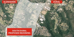
The South Dural proposal for rezoning and development of rural land has fallen through thanks in no small part to the 6,000 residents who wrote submissions and stood together to fight this inappropriate plan.
In 2013, developers Folkestone-Lyon lodged a planning proposal seeking the rezoning of 240 ha of rural land across South Dural, with almost 2,900 new homes to be built. About a quarter of the land to be developed contains high conservation value bushland including critically endangered Blue Gum High Forest. The plan resulted in community outrage and calls for major infrastructure upgrades before the proposal could be considered.
A peer review conducted on behalf of Hornsby Council identified technical gaps in the planning proposal, and the Planning Department recently announced that the proposal could no longer be supported, ‘due to the identified cost to government related to the provision of infrastructure’. Current road congestion is bad enough even before such a development were to be added.