Displaying items by tag: Kuringgai Chase National Park
Ku-ring-gai Chase National Park draft plan of management
KCNP’s current plan of management is over 20 years old and its review is moving at a glacial pace. In August 2019 a series of discussion papers were released for public comment and ideas. It took until January 2022 for a summary of these submissions to be published. Then, finally, a new draft plan of management was open for submissions up until November 2022.
The plan needs to be updated to allow for the large increase in usage of the park and waterways and demand for facilities such as car parks, tracks and trails. Then there is climate change.
Nor does the plan mention the work being undertaken advocating for KCNP to be declared a UNESCO georegion. Success with this project will enhance international recognition and tourism potential of the high quality landscapes of the parks. A detailed plan of management is prerequisite for a successful nomination.
The main issue with the plan of management is that there is no plan; there are suggestions for adaptive reuse, precinct plans to come, proposed strategies, tourism initiatives and memoranda of understandings but few concrete proposals and timeframes on which to comment. It is mostly business as usual.
Ku-ring-gai Chase National Park Plan of Management
Ku-ring-gai Chase National Park is one of the most popular national parks in NSW, with over 3 million visits each year. The existing plan of management for the park was written in 2002. Since that time there has been a steady increase in visitors coming to the park, new recreational uses have become popular, information about the values of the park has improved and new approaches to managing fire and pests and weeds have been developed. The NSW National Parks and Wildlife Service (NPWS) is preparing a new plan of management for the park and island nature reserves.
As part of preparing the new plan of management NPWS has released five discussion papers exploring some of the key management themes that will be included in the new plan:
- aboriginal cultural values
- natural, visitor experience and shared heritage values
- recreational activities
- visitor destinations
- leases licences and consent
NPWS is keen to hear what the community has to say about future management of the park.
Comments close on 15 September 2019. Click here to contribute your ideas and comment.
There will be other opportunities to provide input to the plan of management when the draft plan is exhibited for public comment.
Time for Ku-ring-gai Chase National Park to be World Heritage Listed
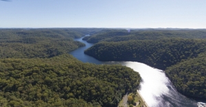
Ku-ring-gai Chase National Park is part of a geographic, geologic and eucalyptus sandstone bushland arc that encircles Sydney. This 12,963 hectare national park is on the Hawkesbury Sandstone Plateau of northern Sydney. It is connected via other national parks to the Greater Blue Mountains World Heritage Area, which in turn is connected to the Royal National Park, south of Sydney.
The Sutherland Shire Environment Centre have been campaigning for the Royal National Park to be World Heritage listed for some time. They argue that the Royal has such cultural heritage importance as it marks the beginning of the global national park movement. The Sutherland Shire Environment Centre even argue that the Royal is the first national park in the world because it was the first to be called The National Park. US’s Yellowstone (1872), used the term ‘national park’ to acknowledge that it was administered by the federal government and not the state government.
Ku-ring-gai Chase National Park is also one of the first national parks in the world to be formed for the intrinsic value of nature. In 1894, it was the second national park declared in NSW. Its corporate seal – Natura Ars Dei or Nature is the Art of God – also expresses a spiritual connection to nature.
The driving force behind Ku-ring-gai Chase National Park was Eccleston Du Faur (1832–1915), a 19th century national parks advocate, adventurer and patron of the arts.
Eccleston Du Faur belonged to the 19th century Sydney intelligentsia and cultural elite who supported the creative endeavours of artists and explorers who ‘believed’ in this new land. Although born in England, du Faur was awe struck by the sandstone beauty of the Blue Mountains and Ku-ring-gai Chase. He played a key role in protecting the Blue Mountains’ Grose Valley because he believed it was one of the most beautiful places in the world.
In 1875 he employed the photographer, Joseph Bischoff, to join him, along with artist WC Piguenit, on an expedition to sketch, paint and photograph the Grose Valley, near Govetts Leap Falls. He planned to send Bischoff’s photographs to the 1876 Centenary Exposition in Philadelphia, USA. He wanted the world to see the Blue Mountains because he believed its spectacular scenery was unrivalled and even surpassed Yellowstone National Park in beauty.
Du Faur was also concerned about Sydney’s fastly disappearing wildflowers and made sure the park’s first by-laws had laws against the cutting of wildflowers. Regretfully this was not strong enough to stop the removal of 4000 waratahs, taken in one month in the post WW II years. The Trustees also prohibited the defacement and destruction of Aboriginal rock art sites and middens in the park.
Recently the Friends of Ku-ring-gai Environment (FOKE) have met with STEP to discuss how they can work together in putting forward the claim for World Heritage listing Ku-ring-gai Chase National Park – one of the first national parks in the world.
Janine Kitson
Camps for Girls at West Head in the 1950s
1956 was my second year out from Sydney Teachers’ College where I trained as a physical education teacher. As a young 21-year-old I was very excited to get the opportunity to apply to be seconded from the NSW Education Department to the National Fitness Council programme. The boys’ programme was run at Juno Head and Little Marley. The girls’ programme was at West Head where an army base had been built during World War II.
The programme ran from Tuesday to Thursday for one or two schools each week. A teacher from each school was asked to attend, but this seldom happened. Generally, I would have about 20 girls, but I recall one time when I had 44 girls on my own!
On Tuesday morning at 9 am the girls would come to the Nat. Fit Office with their food and clothes. I would issue each of them with a Paddy Pallin four pocket A frame canvas backpack and an ex-army groundsheet. I would then show them how to pack their tins of food and usually an enamel plate and mug.
We would then all set off to walk to York Street to catch the double decker bus to Palm Beach. The trip took an hour and a half to the old wharf on Pittwater where we caught the 12 o’clock ferry to Big Mackerel Beach. Then it usually took about one and a half hours to walk up to camp which was about 300 feet above sea level. The girls used to find it hard going as their packs often had tinned food and they were not familiar either with a bush track or carrying a backpack.
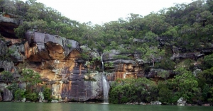
It was a very pretty walk as it wound around the steeply sloping hillside of excellent Hawkesbury sandstone flora looking opposite to the Barrenjoey tombola. Just before the final climb up to West Head there was a waterfall which had to be negotiated by sidling along a narrow ledge.
It was a steep climb up the last 150 feet to the camp at the top where a tired group of girls would be greeted by the camp caretaker Stewart Pitts and Mrs Pitts. A retired couple who had built a cottage in Big Mackerel Beach. Both had a broad Scottish accent and they always had a cup of tea in their kitchen for me.
There was no electricity at camp apart from a generator that supplied lights at night. Perishables were put in a kerosene refrigerator. The girls slept in a 30 bed dormitory of former army bunks which had a horsehair mattress on a wire base. At the southern end there was had a huge fuel stove which I recall I had to use on a couple of occasions when it was too wet to cook outside. It was extremely smoky when the fire was lit.
When they were all settled in we would have a short walk to gather firewood up the dirt road towards Commodore Heights. I would explain some of the early European history to explain where all the names came from and show them remnants of the old military occupation during World War II, when over 500 men were stationed to protect the important rail and road bridges further up the river, linking Sydney with industrial Newcastle and its strategically important steel works.
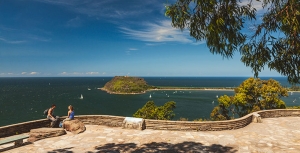
The views were and still are magnificent, looking north up to Gosford and the Central Coast, and opposite to the striking Barrenjoey Lighthouse and the old Custom House on Pittwater.
After gathering firewood for their group, they learnt how to make a tidy wood pile and later how to build a cooking fire in the grates provided near the great rock outcrops on the western side of the mess hall. As many of the girls were from inner city areas, camping and outdoor cooking and washing up were not familiar tasks.
The toilet was a pit toilet or ‘long-drop’ at the end of a pathway back from the camp. The huge septic tank from the wartime was not available then. Water came from a tank.
The first evening we had team games in the mess hall. Lights out was at 9 pm. For many of the girls going to the toilet after dark was quite scary; as were all the strange animal calls at night, especially when possums had an argument on the tin roof. For many, they had not been away from street lights and there were no outside lights at the camp. Settling down at night was quite a challenge for some!
On our second day we went out bushwalking for the day to see Aboriginal engravings or to visit the many delightful creeks, or beaches on the Hawkesbury River. Flint and Steel and Hungry beach being favourite places.
Usually we would see a koala in the trees on Commodore Heights. There was so much of interest in the history and in the vegetation and wildlife. Occasionally, we would scramble down under the old camouflage nets and steep wooden stairs to the gun emplacements near the shoreline of the river. By about 3 pm I would aim to be back at camp to gather firewood for a campfire. Making doughboys, campfire singing and skits prepared by the girls were our evening entertainment.
On the last morning after breakfast we had a general clean-up, then we retraced our steps back down to the ferry at Mackerel Beach, then across to the city bus and a walk to Bridge Street after a great time at Three Day Camp.
In retrospect, this was a great time for nature-based learning and for appreciation of our potential World Heritage, Sydney Basin Sandstone Flora and Fauna. Since the National Fitness Office was taken over by the Department of Sport and Recreation, I feel that school education has lost its appreciation of local geology, flora and fauna-based learning which was then available to a few.
Sadly, schools have generally lost the experience of the joys of bushwalking, and the intrinsic mutual benefits of understanding how our natural heritage and our human health and well-being are inter-connected with the health and well-being of our unique natural heritage.
Click here for an interesting history of pre-war attempts to develop West Head. We are thankful that appreciation of our bushland has changed!
Click here for an account of West Head’s World War II history.
Janet Fairlie-Cuninghame


