
Displaying items by tag: flooding
Fires and floods
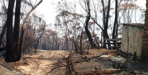
Our Black Summer fires were closely followed by record rainfall and flooding. We were actually up in the Blue Mountains for a week in February 2020 when it virtually poured every day, accumulating more than 500 mm. Soil on steep slopes was either winnowed or swept away along with a mind boggling volume of charred debris. But outcomes from such a scenario can be even worse in a safety sense, as described in an article from The Atlantic Weekly (first published on 1 November in High Country News). I’ve reproduced a couple of paragraphs below.
Two Septembers ago, the residents of Grotto, Washington, woke to the Bolt Creek Fire ripping through the mountains above their homes … No one was hurt, and no houses burned. But now, wildfire survivors in Washington now face a new threat: debris flows. Wildfires can lessen the soil’s ability to absorb water, so when thunderstorms, rapid snowmelt, atmospheric rivers, or rain falling on snow occur in a burned area, that can create a roaring earthen river. Debris flows can move quickly — 30 mph or more — sliding from the uplands to the valley floor in a matter of minutes.
Debris flows are more dangerous than mudslides and slower-moving landslides: They can sweep away boulders, trees, and cars, and threaten everything in their path, including roads and homes and the people who live in them. Last year, in Washington’s Okanogan County, two residents were rescued from their home after earth flowed through a burn scar. Another flow destroyed a cabin and sent a foot of water and mud into at least 30 structures. And in 2018, 23 people were killed when heavy rains triggered a debris flow in the burn scar of Southern California’s Thomas Fire.
John Martyn came across this article in Apple News that’s very relevant for fires in our mountainous districts.
Flooding Wilderness, Wild Rivers and World Heritage
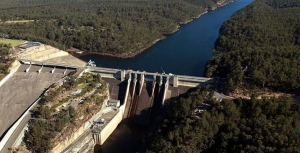
Two weeks before the Federal election with Warragamba Dam threatening to spill due to severe storms, the Baird government committed to raising the dam wall to prevent potential flood impacts on marginally held seats in western Sydney. Perhaps for the same reason, NSW Labor reversed its ‘don’t raise the dam’ position and supported the proposal. However, no new information was released to justify this decision. The economic case and environmental impact statement for such a major project are years away, so it seems to be another case of decision now, judgement later for NSW.
This is not a new proposal. A similar scheme was defeated in 1995 following a strong campaign by the Kowmung Committee led by Andrew Cox, after the Greiner–Fahey government had committed to raising the wall in 1993. The subsequent Carr government then approved construction of a large spillway beside the dam, completed in 2002, to protect it from major floods.
In December 2012 the NSW government accepted a recommendation from Infrastructure NSW in its 20 year State Infrastructure Strategy:
to review all major flood mitigation options available, including raising the Warragamba Dam wall, to significantly reduce the potential economic and social impact of flooding in the Hawkesbury Nepean Valley
This report was overseen by chief executive officer, and former Sydney Water head, Paul Broad, and ex-premier and chairperson of Infrastructure NSW, Nick Greiner. To them the dam was unfinished business.
Raising Warragamba Dam’s wall will inundate over 3,000 hectares of World Heritage listed national park lands, wilderness and wild rivers. Lower reaches of protected wild rivers, including the Kowmung, Coxs and Nattai Rivers, will be flooded. Temporary inundation caused by the proposal will scar wilderness areas, kill riverbank vegetation and deposit sediment. The affected parts of the southern Blue Mountains national parks, arguably the most protected parks in Australia, may have to be revoked, as they will be degraded if this scheme proceeds.
Temporary impoundment of floodwater will result in the ‘bath-ring effect’ – visual scarring of the landscape when natural areas are temporarily inundated. The NSW government would like us to believe that the drowned World Heritage Area will not be degraded, but once native vegetation is inundated and smothered in sediment, it becomes replaced by an eroding mess of bare earth and weeds.
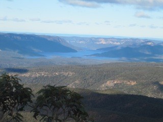 Views from McMahons Lookout, Splendour Rock, Burragorang Lookout and many others in the Blue Breaks will be ghastly. Lake Burragorang will have a much expanded ‘bath-ring’ and may also gain an enlarged Schedule One area further up the Coxs River, interfering with Katoomba to Kanangra walks, spoiling or placing off limits favoured campsites.
The Camden White Gum forests in the Kedumba Valley, listed as vulnerable under Commonwealth environment laws, will also be lost when flooded.
The Blue Mountains Conservation Society is opposed to the development. Vice-president Tara Cameron said:
We are very concerned that between Badgerys Creek airport and raising the Warragamba Dam wall, the world heritage values of the Blue Mountains will be deemed at risk by UNESCO. Australia has an international obligation to protect these areas not destroy them. This is an environmental disaster
(BM Gazette, 20 June 2016).
Developer Benefits
Former National Parks Association CEO, Andrew Cox, now with 4Nature, believes that the proposal may put more people at risk of flooding, not less. ‘We’re worried that by raising the dam and providing some level of protection it will actually trigger development on the flood plain,’ Mr Cox said.
Western Sydney Leadership Council chairman, Christopher Brown, has already flagged developing flood-prone land as a potential funding source for the dam wall extension.
‘I think there’s the capacity to use a value-capture funding method to reduce the impact on taxpayers,’ he said.
‘Maybe via a levy on land release that was previously considered flood-prone so we might be able to do it at a cheaper rate than what the government’s talking about.’ He suggested the wall extension could potentially be made higher than 14 m if such a levy was charged (Sarah Gerathy, ABC News, 17 June 2016).
Removing planning restrictions to develop flood prone areas will be highly profitable for some, but will endanger lives. In fact much of the North West Growth Centre around Riverstone is significantly affected by flood prone land. Residential areas are nevertheless planned within the maximum possible flood zone despite the acknowledgement that the enlarged dam will have no effect on extreme floods.
Flooding associated with the Upper Nepean which recently inundated Picton, as well as floods coming down the Grose, Colo and Macdonald rivers are not mitigated by the proposed dam wall raising.
Solutions
The best way to reduce the impacts of flooding on people is to relocate low-lying homes and avoid further building in flood prone areas. Floodplains are for floods and the proposed higher dam wall does not alter that fact.
Given Sydney Water’s new capacity to access water from the lower levels of Warragamba Dam, and the water security provided by the desalination plant, a less damaging solution would be to reduce the dam’s full storage level by a third and allow that proportion to be used for flood storage. The dam’s hydroelectric plant could be refurbished and then operate to lower the stored water to desired levels following a flood, while generating electricity for the national grid.
Efficient use of existing dam capacity, along with better flood planning and emergency response will save lives and the World Heritage area from an unnecessary $700 million dollar dam project and its contingent real estate development boom on the floodplain.
This article was written by Keith Muir. It was originally published in the Colong Foundation for Wilderness Bulletin, August 2016 edition. Reprinted with permission.