
STEP Matters 190
- Default
- Title
- Date
- Random
- Hollows as Homes The Australian Museum has joined the Royal Botanic Garden Sydney and Sydney University in launching a new…Read More
- Firstly, some history; in 2003 UTS decided to vacate the site and sought a rezoning for residential development with 560…Read More
- Thirlmere Lakes lie in an area that was subject tectonically to weak uplift and gentle monoclinal warping at the ill-defined…Read More
- Every day there’s an outdoor event to celebrate or commemorate something or other, and balloons will be released. It looks…Read More
- Following the serious power blackouts that occurred in South Australia and near misses in other states, gas-fired power stations have…Read More
- The Australian Association of Bush Regenerators was established in 1986 out of concern for the continuing survival and integrity of…Read More
- Ku-ring-gai Council has commissioned a report on developing the tourism potential of the municipality. Ku-ring-gai Destination Management Plan 2017 to…Read More
- The name Wianamatta is familiar through the loose usage of the term ‘Wianamatta Shale’ to embrace the Triassic rocks that…Read More
- Sydney's Blue Gum High Forests built colonial Sydney. By the 1850s most had gone. However a few patches survived. The…Read More


Some ways Citizens can Help Science

Hollows as Homes
The Australian Museum has joined the Royal Botanic Garden Sydney and Sydney University in launching a new citizen science project called Hollows as Homes. Funding support is provided by the Australian government.
The project builds on the Cockatoo Wingtags project and involves the same researchers, led by Dr John Martin.
In urban and agricultural areas large, hollow-bearing trees are in decline, but many species of animal rely on tree hollows for shelter and breeding.
In NSW, hollow-dependent species include at least 46 mammals, 81 birds, 31 reptiles and
16 frogs. Of these, 40 species are listed as threatened with extinction. This is why the ‘loss of hollow-bearing trees’ has been listed as a Key Threatening Process to biodiversity throughout Australia.
One reason that their loss is significant is the length of time that it takes for a tree hollow to form (often more than 100 years). More hollow-forming trees are needed to replace the losses that have occurred already. The solution being trialled is to create artificial hollows and nest boxes.
The Hollows as Homes project aims to conduct the first landscape scale assessment of tree/nest box/cut-in hollow distribution, type and wildlife use. Data generated will inform council plans for retaining important habitat trees, planting future habitat trees and supplementing missing habitat.
The project will harness the enthusiasm of local residents to report, measure and monitor tree hollows in their backyards, streets and parks.
Participating is easy – check the trees in your backyard, street, park, paddock or the bush, and report the hollow(s) online.
FeralScan
Feral animals cause over $720 million damage each year in Australia and threaten our native wildlife. FeralScan allows you to help reduce feral animal damage by mapping feral animal sightings, damage and control activities in your local area.
Ferals covered by the program include Indian Mynas, foxes, rabbits, feral cats and many more invasive species.
Gas is not the Solution for Transitioning our Energy Supply away from Coal
Following the serious power blackouts that occurred in South Australia and near misses in other states, gas-fired power stations have been touted as the one of the best means to transitioning away from our aging coal-fired electricity generation system. This is short-term, simplistic thinking that will be detrimental in the longer term, and the Climate Council has just released a report explaining why. The report is called Pollution and Price: The Cost of Investing in Gas.
The Climate Council is the crowd funded organisation led by Tim Flannery that replaced the Climate Commission that was abolished by the Abbott Government shortly after they came into power. They aim to provide independent, expert information on climate change issues.
Here is a brief summary of the main findings.
Use of gas does not reduce emissions sufficiently
Australia must reduce greenhouse gas emissions down to zero by 2050 in-line with international goals. Fossil fuels (coal, oil and gas) all produce greenhouse gas emissions driving climate change. Limiting global temperature rise requires that they are all phased out. Gas is not sufficiently less polluting than coal to garner any climate benefit.
Greenhouse gas emissions are produced both from gas power stations and gas production (for instance, methane from gas leaks). Methane is 86 times more potent as a greenhouse gas than carbon dioxide over a
20-year period.
New gas power plants are less polluting than coal. However, when the entire supply chain of gas production is considered, gas is not significantly less polluting than coal. Current levels of reliance on gas power in Australia must be reduced to play our role in limiting global temperature below 2°C. Expanding gas usage is inconsistent with tackling climate change as it locks in emissions for decades into the future.
Greater reliance on gas will drive higher power prices
Australia’s liquefied natural gas exports are pushing up the price of gas power as domestic gas prices are now inextricably linked to world market prices for oil. This will continue into the foreseeable future.
The most economic and accessible reserves are now being exported. Further gas expansion will drive increased reliance on unconventional gas, which is expensive. Reliance on gas power is also driving power price spikes, particularly in South Australia, Queensland and increasingly in New South Wales, due to lack of competition among gas power companies.
Investment in new gas plants is financially risky
The large increases in future gas prices and volatility resulting from liquefied natural gas exports together with domestic gas prices controlled by relatively few producers, make investments in new power plants using gas very risky. New gas power plants would rely on ageing gas production infrastructure (e.g. processing plants and high pressure pipelines) that is increasingly vulnerable to failure. Costs of updating this infrastructure and accounting for methane leakage must be factored into policy and investment decisions.
New gas infrastructure locks in carbon emissions for decades. Future regulations may impose higher costs or stricter limits on emissions in the future, impacting on the economic viability of gas production and electricity generation, stranding investments.
Significant development of new gas plants is unfeasible without a massive expansion of unconventional gas
The sheer volume of gas required, the cost, the lock in of long-term emissions, environmental risks and lack of support from communities near gas wells makes this unrealistic. Currently the emissions from unconventional gas in Australia are unknown due to a lack of measurement and data. This presents a long term carbon risk to investors as high emissions fossil fuel infrastructure faces the possibility of future regulation due to climate change. Development of new unconventional gas is entirely out of step with meeting the Australian government’s climate change goals.
Renewable energy can provide a secure, affordable alternative to new fossil fuels
New renewable energy is cost competitive with new gas. The cost of renewable power and storage, particularly solar, wind and batteries, continues to fall and has no associated fuel costs. This contrasts with rising and volatile gas prices.
Technologies such as solar thermal, hydro and biomass plants can meet demand for electricity at all times of the day as well as meeting technical requirements for grid stability. Combining these technologies with wind, solar PV, and large-scale energy storage, can meet electricity demand round-the-clock. Using existing gas-fired generators and supply infrastructure prudentially to complement wind and solar power while scaling up a range of renewable energy technologies, energy storage and energy efficiency measures could deliver a limited benefit, provided the end goal is phasing out the use of all fossil fuels as quickly as possible.
Conclusion
The report concludes that Australia should not provide policy support for new gas power plants or gas supply infrastructure. Existing gas plants should be thought of as a short-term, expensive, emergency backup as renewable energy and storage is rapidly scaled up.
Bubbles not Balloons

Every day there’s an outdoor event to celebrate or commemorate something or other, and balloons will be released. It looks spectacular for a moment or two, but they’re soon forgotten. What happens to them? Most end up in our seas, where they are eaten by marine wildlife, including seabirds. It sounds frivolous, but it’s become a major conservation problem.
BirdLife Australia has thrown its support behind a campaign by Zoos Victoria and the Phillip Island Nature Parks to shine a spotlight on this issue.
Most people aren’t even aware that the simple act of releasing balloons into the air poses a major danger to wildlife. However, the facts are startling. A CSIRO study found that balloons are in the top three most harmful pollutants threatening marine wildlife – along with plastic bags and bottles.
Albatrosses, cormorants, penguins and pelicans are all affected by this, but of all Australia’s seabirds, shearwaters, or muttonbirds, are the most badly affected when it comes to ingesting plastic debris.
For example, the decline of Flesh-footed Shearwaters on Lord Howe Island has been directly linked to the ingestion of debris, with balloons and their plastic attachments, one of the most prevalent and readily identifiable items found inside them. Further, two separate studies have found that 100% of Short-tailed Shearwaters contain plastic in their digestive systems.
The balloons fill the birds’ digestive tracts while offering no nutrition, and slowly poison them as toxic chemicals leach into the birds’ tissues.
Birdlife Australia is joining Zoos Victoria and Phillip Island Nature Parks to encourage Australians to make their outdoor events wildlife-friendly. The best way to do this is by choosing to use bubbles instead of balloons to reduce this source of harmful waste.
Help spread the word to use bubbles instead of balloons at outdoor events. It’s a simple act but it can make such a big difference.
This information comes from Birdlife Australia.
Further reading:
St Ives Showground Precinct – a Tourism Centre for Ku-ring-gai?
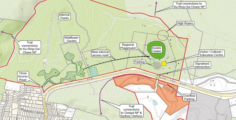
Ku-ring-gai Council has commissioned a report on developing the tourism potential of the municipality. Ku-ring-gai Destination Management Plan 2017 to 2020 is open for submissions until Friday 12 May.
The report focuses on a plan:
… to redevelop the St Ives precinct to achieve a ‘wow factor’ to attract visitors, benefit residents and help grow the local visitor economy.
The aspirations presented in the report are:
- to develop the precinct as a distinctive destination for nature-based and Aboriginal cultural tourism experiences
- to establish the precinct as a unique trekking hub and gateway for adjoining national park trails and Hawkesbury River to Sydney Harbour linkages to achieve similar iconic status as the Three Capes Track in Tasmania
- to develop events infrastructure and supporting facilities to position the precinct as centre for international-standard performances similar to those staged at the Hope Estate in the Hunter Valley for music, cinema and performing arts
- to rebrand the precinct to reflect its competitive advantage and world-class potential (e.g. Centennial Parklands and Western Sydney Parklands)
- to commission a revised master plan to balance existing recreational and community activities with a new tourism focus under a trust governance model used elsewhere
- to achieve the precinct’s full potential as a seven day a week, four seasons integrated mixed-use destination for international and domestic visitors
Accommodation Proposals
The possible developments described are more prosaic. Many of the suggestions are for the upgrading of existing facilities but STEP would be concerned by proposals for:
… unique accommodation experiences that complement these experiences (e.g. a five-star eco-tourism lodge sited near the boundary of the national parks escarpment, hostel accommodation for education and recreation groups and flash-camping).
Details are needed on how this sort of development can be achieved without damaging the environmentally sensitive E2-zoned land including endangered the Duffys Forest Ecological Community. The map at the top of the page also seems to show some national park land as being within the precinct. STEP will be looking at these plans very closely.
The report does acknowledge the environmental constraints:
It should be recognised that the recommended strategy, focused on nature based and Aboriginal cultural tourism, has environmental protection and enhancement at its core. There are numerous examples around the world of sensitively designed accommodation and infrastructure within and adjacent to national parks and areas of high ecological value. It is proposed that all new development in the St Ives precinct will be sensitively designed, constructed and operated in accordance with best practice and there should be a net improvement to environmental performance on site such as increased biodiversity, improved drainage runoff, Aboriginal cultural interpretation and signage. It should also be appreciated that many parts of the St Ives precinct are in a degraded environmental condition.
Walking Tracks
Proposals to upgrade walking tracks within the precinct and links to Ku-ring-gai Chase and Garigal National Parks are welcome. Many of the existing tracks are degraded and unattractive because of weed infestations. Funding has always been a problem, both for council and National Parks and Wildlife Service. This highlights the perennial problem, where will the money come from? It seems that public private partnerships and commercial leases are the only hope.
National Parks Development
The report (p19) states that the NSW government is about to release a new master plan for national parks covering partnerships with nature-based tourism stakeholders. A draft new Plan of Management for Ku-ring-gai Chase National Park is due to be released this year. It is going to be another busy year for preparing submissions.
Old Nursery Site
The plan for an indoor sports centre at the site of the nursery does not get a mention. Has that idea fizzled out? Instead there is mention of a native wildflower nursery funded by the private sector.
Road Links and Parking
The report highlights the need for traffic lights and a pedestrian crossing at the main entrance on Mona Vale Road. It also suggests that the exit at the Wildflower Garden be closed with internal roads being used to gain access via the main showground. There is a suggestion for overflow parking on the other side of Mona Vale Road. The effects of car parking on the Duffys Forest vegetation and soils has always been a problem and is currently controlled by the use of bollards and parking restrictions. If the number of visitors is to increase significantly the control of parking will be more important than ever.
Development of Crimson Hill, the Old UTS Site
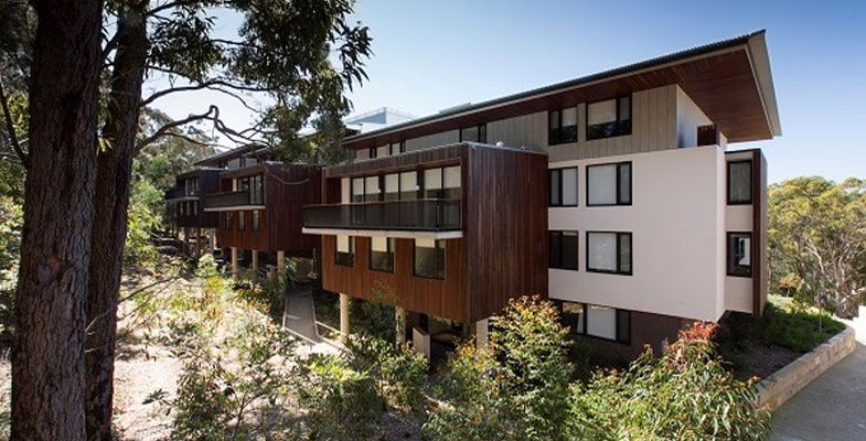
Firstly, some history; in 2003 UTS decided to vacate the site and sought a rezoning for residential development with 560 buildings. Ku-ring-gai Council refused the application so the state government intervened and declared the site to be a Part 3A project under the EPAA Act. The Minister for Planning became the decision maker.
STEP was a member of a community consultative committee established to demonstrate that the community had been consulted. The committee opposed many aspects of the development plan. There were some wins in the transfer of 9 ha of the land to management by Lane Cove National Park and some improvements including a reduction in the number of dwellings approved for the site, the retention of a full-sized oval for community use and the retention of heritage buildings.
Of course there are no additional funds available to the NPWS to manage the additional national park land. A significant area of bushland has been modified to establish the asset protection zone and of course there will always be traffic and parking problems especially when the new school is operating. The management of stormwater and the risk of weed encroachment will need to be closely monitored.
Crimson Hill – Defence Housing Australia (DHA)
Crimson Hill estate was designed along simple, environmentally sound principles aimed to establish a new integrated community connected by bushland trails and elevated walkways. The objective was to promote community interaction and well-being. It has 345 dwellings occupying a portion of the 12.6 hectare site of rezoned land that DHA purchased from UTS in March 2011.
A significant area of this land, including publicly accessible bushland and nature trails for bushfire management, is in the care of the new residents via a Community Management Association.
It is DHA’s first multi-residential housing project and is being constructed in five phases. The name is a salute to the colour of the ribbon on the Victoria Cross medal. Each residential precinct is named after one of the five recipients of the VCs awarded for bravery on a single day during the battle of Lone Pine in 1915:
- Burton’s Place – Alexander Stewart Burton
- Dunstan Grove – William Dunstan
- Tubb’s View – Frederick Harold Tubb
- Hamilton’s Corner – John Hamilton
- Shout Ridge – Alfred Shout
The estimated 700 residents, expected to occupy Crimson Hill eventually, comprise a mix of Defence personnel and civilians. There are many owner-occupiers and tenants.
DHA is an Australian government enterprise established by the Defence Housing Act 1987 to supply housing and related services to Australian Defence Force members, in-line with operational requirements. Launched in 1988 as a statutory authority, DHA is now a commercially-funded organisation that has projects all over Australia. During 2015–16, DHA managed 18,767 properties for ADF members and civilians.
Before construction commenced in 2013, the brownfield site had significant areas of native remnant bushland around the university campus. A detailed ecological assessment was done before any clearing started.
Indigenous seeds were collected from endemic species and these were replanted. It is estimated that over 90% of plants on the site now are native and the majority are locally occurring species.
The centrepiece of the estate is Charles Bean Sports Field, opened in December 2013. It was developed by DHA with Ku-ring-gai Council and the Northern Suburbs Football Association. The purpose-built, publicly-accessible sports field has received FIFA 2-star certification, the highest accreditation an artificial grass field can receive. There are football teams coming and going continually and it is rare to see the field without players on the evergreen surface.
Rainwater is harvested within the buildings for re-use and some have solar panels to reduce main-grid energy usage. Environmental consultancy Cundall, estimates the buildings will use 60% less energy and water than standard multi-residential developments. The residential development was designed by two architectural companies: Bates Smart and Architectus. Construction was by two building companies: Grindley and Ganellen.
The recently finished Shout Ridge is the first apartment building in Australia to receive a prestigious 6-Star Green Star – Multi Unit Residential Design V1 certified rating for environmentally sustainable design from the Green Building Council.
New School on the Horizon
The latest good news for Lindfield residents is that planning is underway for a major refurbishment of the empty UTS building that remains from its previous use as a university. The building is earmarked to become a new K to 12 school.
The large concrete building was handed over to the NSW Education Department as part of a land swap with UTS. Eventually 2,000 primary and secondary students are anticipated to attend the new school. It hopes to have high quality technical spaces for science, engineering, hospitality, visual and performing arts, as well as music and film. And there will be a childcare facility.
The former UTS building has architecturally heritage because it won the prestigious Sulman Medal for architecture in 1978. This is the highest award given in Australian architecture.
New Walking Track
NPWS and DHA, with the assistance of Friends of Lane Cove National Park, are building a new track from Crimson Hill to Lane Cove National Park. Locals will be able to walk along this bushland track and stroll among wonderful angophora, wattle and eucalypt trees to get down easily to Lane Cove National Park all without any need to get into a car. At a construction cost of more than $220,000, the track will be one more amenity for the residents of Crimson Hill and other locals.
Note: As it is, the track is not shown on our new map, Walking Tracks of the Lane Cove Valley. An example of how hard it is to keep up-to-date.
Lots More Development
As President of the Friends of Lane Cove National Park, Tony Butteriss points out in Regenavitis, wherever you look in Sydney now, there is more development and if feels as if it is getting closer to Lane Cove National Park. There are numerous projects coming right on the edge of the Park including the old UTS site, old Screen Australia site (adjacent) and redevelopment of the Acoustic Laboratory. However, the development that makes all the others look as if they are only playing, is the one at the Epping Road end of Delhi Road. Strictly speaking it is not one but at least three different developments planned to have a total of more than 2,200 units. This will have an impact of (at least) 5,000 people.
This particular development is a worry but consider the cumulative effect of all of them. Each development reduces habitat surrounding the Park. Each brings more hard surfaces and increases the speed of run-off after storms. And each brings visitor overcrowding to the Park. What can local groups do about this? The Friends hope to persuade the developers to fund some restoration projects.
The February edition of Regenavitis, the newsletter of the Friends of Lane Cove National Park, included the following update on the development of the former UTS (Ku-ring-gai) site in Lindfield that is now called Crimson Hill. We thank them for permission to reprint.
Click here for more information on the campaign.
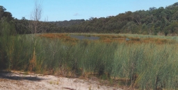
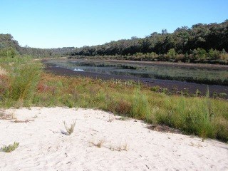
Thirlmere Lakes and East Coast Lows
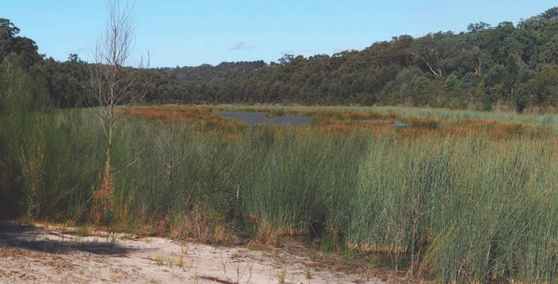
Thirlmere Lakes lie in an area that was subject tectonically to weak uplift and gentle monoclinal warping at the ill-defined southern end of the Lapstone Structural Complex, a feature that is highlighted further north by the bold escarpments of the Lapstone Monocline and the Kurrajong Fault. The chain of five shallow, swampy lakes lies in the remnants of an alluvium-filled, mature, incised-meandering river system that ancestrally drained westwards into the Wollondilly catchment. However, as a consequence of the gentle upwarping plus relative subsidence of the adjoining Cumberland Basin, the drainage direction in the north-east sector of the chain has been reversed due to headwater capture by Cedar Creek, which flows via Stonequarry Creek south-eastwards to the Nepean. The lakes are essentially stranded on a gentle watershed between two drainage systems.
The catchment area of the lakes is relatively small, roughly 10 km2 of Hawkesbury Sandstone spurs and side-valleys, and there is no long distance drainage flow-through along the dismembered ancient river course. But they overlie a substantial thickness of water-saturated alluvium whose water leaks away very slowly, and are in one sense the surface manifestation of its rising and falling water table.
Rises and Falls in Water Level
Latter day fluctuations in the water levels in these ancient lakes have been the subject of much recent debate centred around the possible effects on aquifers of longwall coal mining in nearby Tahmoor Colliery, operated by Xstrata. Other suggested factors have been the pumping of aquifers for local agricultural purposes.
Levels were particularly low in June 2010 (photo bottom left) and then rose quite slowly – below many people’s expectations (photo at the top of the page was taken in May 2015). However, the lakes now (March 2017) are as full as they’ve been in recent decades (photo bottom right).
You can easily access the rainfall data of the Bureau of Meteorology’s automatic rain gauge located near Buxton 3 km to the south, and from it you can deduce some interesting correlations.
The low water levels of 2010 following the exceptionally dry year of 2009 (photo bottom left) occurred when only 588 mm was recorded against a mean of 856 mm. In strong contrast, in 2017 (photo bottom right) is a hangover from the massive east coast low falls of June 2016 when 387 mm was recorded at Buxton, including a one day fall of 188 mm (contrast the wettest monthly total for 2009 of only 97 mm). Rains from east coast lows can overwhelm everything over huge areas, create massive floods, and fill and sometimes overflow our storage reservoirs. The plants don't need all that extra water, especially in winter, and what doesn't run off will bypass their root systems and swell the aquifers, including those that feed the lakes.
And what of the gradual rise in lake levels from 2010 onwards that had many people puzzled? Well, four out of the six years from 2010 to 2016 brought above average rainfall, peaking at 971 mm in 2013, and the other two were only slightly below – 736 mm in 2011 and 841 mm in 2014. The maximum one day fall in that period was 133 mm in January 2013 and January and February of that year scored a combined total of 326 mm. This was thus a slightly wetter than average time and the photo at the top of the page shows Lake Werri Berri recovering, roughly half full, in May 2015, a year in which the preceding month of April was the wettest one with a total of 164 mm.
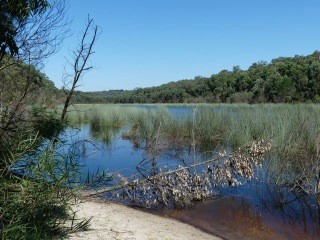
Are we still pointing a finger at Xstrata's longwall mine system? Well this is a personal opinion and don't quote me as an expert, but I believe it can only be a minor factor at most; rainfall versus evaporation is demonstrably the major control, as has been the case from historical records and one which is built into the conclusions of the report cited below. How climate change will affect things in the future is unknown, though there is already evidence of increasing intensity within rainfall events. More ones like June last year can only be good for the lakes.
Recommended reading: Thirlmere Lakes Inquiry Final Report of the Independent Committee, 23 October 2012
John Martyn recently visited Thirlmere Lakes to see how the area has fared during the recent period of freak weather. In STEP Matters 186 we wrote about concerns that the significant drop in water levels since the mid-1980s was due to longwall mining. It seems the picture has changed considerably.
Wianamatta Group

The name Wianamatta is familiar through the loose usage of the term ‘Wianamatta Shale’ to embrace the Triassic rocks that overlie the Hawkesbury Sandstone. This is an informal term, distinctly woolly in its definition, and should be avoided, but if it must be used, ‘shale’ or ‘shales’ should always be spelt lower-case.
Wianamatta Group, derived from the Aboriginal name for South Creek, was established formally in 1952, fully documented in 1954 and further revised in 1979. The group consists of three formations: the Ashfield Shale, Minchinbury Sandstone and Bringelly Shale. It occupies the centre of the Sydney Basin, lapping onto the lower Blue Mountains and extending southwards to the Southern Highlands. It has been defined largely from drillhole data because outcrop is mostly limited to road and railway cuttings and quarries.
The thickest stratigraphic section drilled was encountered in hole DM Razorback DH1 on
Mt Hercules near Picton. This passed through 304 m of Wianamatta Group strata consisting of 257 m of Bringelly Shale, 2 m of Minchinbury Sandstone and 45 m of Ashfield Shale.
The Ashfield Shale and Minchinbury Sandstone correlate well across much of the 50 km long area covered by the same Department of Mineral Resources drill program, whereas the Bringelly Shale is much less uniform, its variability enhanced by the presence of many scattered sandstone lenses of limited lateral extent but up to more than 40 m in thickness that are hard to correlate.
The Wianamatta Group was deposited on a coastal lowland subject to early minor marine incursions. The depositional environment evolved upwards into lagoonal or marshy lowland crossed by meandering rivers that brought surges of sand that filled channels and created the sandstone lenses.
Ashfield Shale
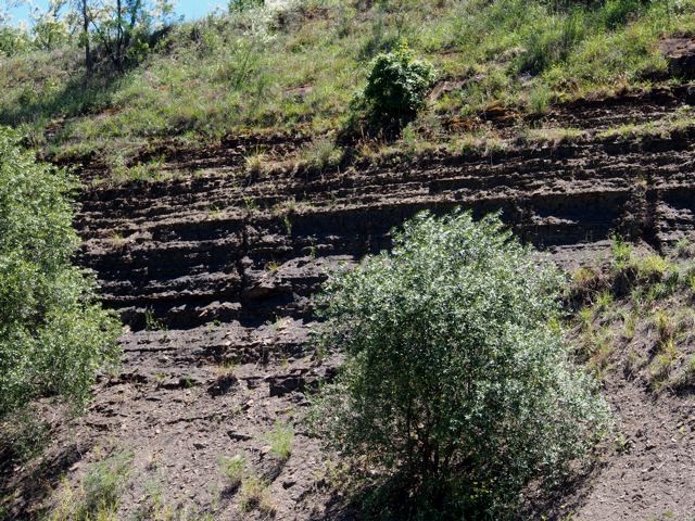
The Ashfield Shale has a maximum drilled thickness of 61.6 m at Erskine Park near the centre of the basin and has been subdivided into four members consisting of alternating layers of dark ferruginous shale and laminite.
All of these members were once incompletely exposed in the Thornleigh brick pit but this has since been filled in. Now, the most viewable Ashfield Shale faces can be found along the North Shore and Northern railway lines and Bells Line of Road, and in a number of other road cutting exposures such as Horace Street, St Ives and in the Picton–Campbelltown area.
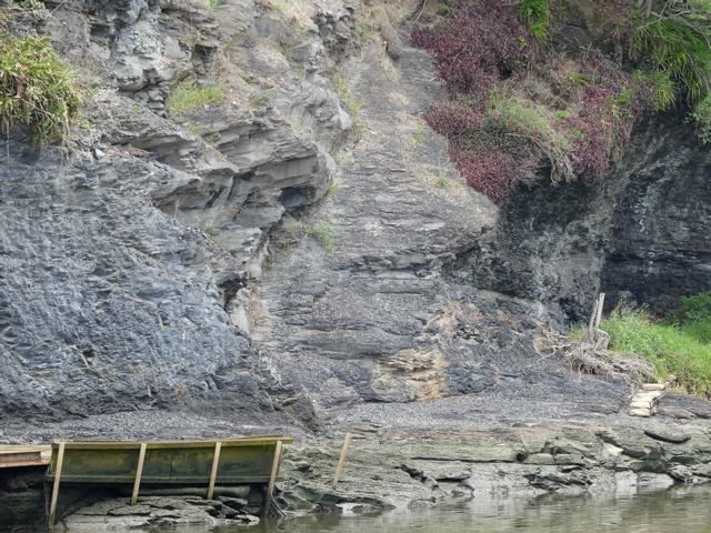
The best natural exposure is the river-cliff in Mulgoa Nature Reserve south of Penrith which exhibits dark coloured Mulgoa Laminite Member, and also the river-cliff opposite the Parramatta ferry wharf (see photo). The Mulgoa cliff is visible from Mulgoa Road through gaps in a screen of riparian forest but is difficult to access on foot.
An important feature of the Ashfield Shale is its relatively high phosphorus content of between 0.1 and 0.9% P2O5. This is in strong contrast to the negligible amounts of phosphorus in the underlying Hawkesbury Sandstone and is also significantly higher than levels in the Bringelly Shale. Phosphorus values in Ashfield Shale measured from drill core tend to be spiky with prominent peaks, and it appears the element resides in thin beds rich in phosphatic siderite nodules.
Minchinbury Sandstone
The Minchinbury Sandstone is a widespread but thin (less than 6 m) marker band of fine-grained, bluish-grey, brown-weathering rock that is rarely seen in surface outcrop and is known mainly from drill intersections. It is a quartz lithic sandstone with grains mostly of quartz with about 10% of rock grains. It also contains calcite, plus micas, notably muscovite which can be seen sparkling on broken surfaces. Another very similar, intermittent sandstone bed lies immediately above in the lower Bringelly Shale. Both sandstones weather deeply to a crumbly or flaky condition and surface expressions are subtle, or the sandstone outcrops are smoothed over by soil profiles or pasture.
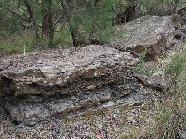
Minchinbury Sandstone at Minchinbury is more than 100 m deep in a borehole, and finding its outcrops elsewhere, especially natural ones, is a challenge. Near the top of the Mulgoa shale cliff there is a thin (less than 1 m) band of very fine-grained flaggy sandstone which has been interpreted as Minchinbury. In Lansdowne Park (see photo) there is a train of large, disjointed sandstone slabs whilst other small outcrops and floaters are scattered along a low, hillside bench. There are a few others, but if you happen to know of any more, please let me know.
Bringelly Shale
The Bringelly Shale is the uppermost formation of the Wianamatta Group and also the youngest Triassic sedimentary unit in the Sydney Basin. Reaching more than 250 m in the south, it is also one of the thickest.
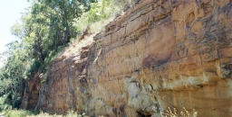
The commonest rock type exposed is a mixture of finely-bedded shale, laminite and siltstone. Seen in road cuttings this differs from the dark, almost black, clay-mineral-rich Ashfield Shale, being more variable, often accompanied by disconnected sandstone lenses that become thicker and more prominent from Western Sydney Regional Park southwards, forming most of the hilly country between Campbelltown and Picton. Driving south or into the Picton area you can't miss them. They form intricate escarpments up to 200 m high, and the sandstone cliffs along the old Hume Highway near Picton (see photo) are of the two thickest ones, the Mt Hercules and Razorback Sandstone Members (see photo at the top of the page).
Such sandstones have been described as lenses and stacked multiple lenses and have been interpreted as infill deposits in channels created by rivers meandering across the swampy lowland. Their lateral extent is not great and they are difficult or impossible to correlate with one another across distances of more than a few kilometres, but they are important in defining the landscape, their scarps and hollows nurturing sub-types of endangered Cumberland Plain Woodland floras.
Ashfield Shale Floras
Ashfield Shale outcrop extends to higher elevations and into higher rainfall areas than Bringelly Shale. These include the North Shore where rainfall zones exceeding 1000 mm, and similarly the Bilpin–Mountain Lagoon area. Where the shale forms cappings that fringe the Illawarra escarpment the mean annual falls may exceed 1500 mm by a significant amount.
Blue Gum High Forest is familiar to most STEP members and needs little description here. Most members live within 10 min drive of Dalrymple-Hay and Sheldon Forest or can easily reach more far flung localities like the Blackbutt forest of Galaringi Reserve or the Blue Gum, Grey Ironbark forests of Rapanea Community Forest, both in the Carlingford area. But even more diverse treats are in store in the Blue Mountains where the Mountain Blue Gums Eucalyptus deanei and Monkey Gums E. cypellocarpa grow tall and stately in the endangered Blue Mountains Shale Cap Forest of the Bilpin area. These two are members of a cornucopia of eucalypt species as the community grades laterally into Sydney Turpentine Ironbark Forest and Shale Sandstone Transition Forest. Appearing are Grey Ironbark, Mountain Mahogany E. notabilis, Grey Gum, White Stringybark, Sydney Peppermint, and of course not forgetting Turpentine.
Have you visited the Illawarra Fly Treetop Walk at Knights Hill near Robertson? If not it's worth an outing, rounded off by a pie at the Robertson Pie Shop. The walk meanders through the crowns of two tall eucalypt forest species,
Gully Gum Eucalyptus smithii and Brown Barrel E. fastigata. Ashfield Shale sits atop a sheer cliff of Hawkesbury Sandstone protected by a large capping of Cenozoic basalt. The weather station at the pie shop records a mean annual rainfall of nearly 1600 mm.
Scheyville National Park near Pitt Town is perhaps the best place to look at lower rainfall communities on Ashfield Shale. It includes part of the former Pitt Town Common grazing lands whose pasture merges into tracts of quite dense woodland and forest. The dominant plant community is the critically endangered Cumberland Plain Woodland whose principal tree species are Grey Box Eucalyptus moluccana, Forest Red Gum E. tereticornis and Narrow-leaved Ironbark E. crebra. The forest floor is often grassy and may be sprinkled with quite delicate wildflowers like Blue Trumpet Brunoniella australis in spring and summer. Cumberland Plain flora shares many herb and shrub species with the tablelands and slopes of NSW but in the grassy ground flora you'll also be reminded of aspects of Blue Gum High Forest.
Bringelly Shale Floras
The Minchinbury Sandstone is so thin and it weathers so readily that, vegetation-wise, it is inseparable from the Bringelly Shale (or for that matter the underlying Ashfield Shale).
The Bringelly Shale supports a more varied range of Cumberland Plain plant communities than the Ashfield Shale described earlier. Because of the presence of sandstone beds and lenses, its country can be quite hilly, with sheltered slopes and valleys, and this has led to the creation of Shale Hills as distinct from Shale Plains woodlands as Cumberland Plain Woodland subtypes. Sheltered valleys and steep slopes have also nurtured additional communities such as Western Sydney Dry Rainforest and Moist Shale Woodland, both also listed endangered. However, rainfall nowhere reaches levels that would support tall blue gum forests like those on Ashfield Shale in Sydney’s upper North Shore or the lower Blue Mountains.
Reserves carrying native vegetation on Bringelly Shale are relatively small, widely scattered and often subject to weed invasion especially by African Olive, Lantana, privet species and African Lovegrass. They include Lansdowne Park, remnant pockets within Mt Annan Botanic Gardens, Mulgoa Nature Reserve, Shanes Park, and Wianamatta and Western Sydney Regional Parks including Kemps Creek.
In Western Sydney Regional Park you can wander from the main park areas into quite dense Spotted Gum forest, and into sheltered niches below escarpments formed by sandstone lenses which carry Moist Shale Woodland and Western Sydney Dry Rainforest, with odd ring-ins like White Mahogany Eucalyptus acmenoides amongst the Spotted Gums and Forest Red Gums. Understory species include Mock Olive Notelaea longifolia and Hairy Clerodendrum Clerodendrum tomentosum. Climbing plants are particularly diverse and include native Grape Cayratia clematidea and Gum Vine Aphanopetalum resinosum (from personal experience, too aggressive to grow in the garden).
Main reference: Herbert, C. (1979) The Geology and Resource Potential of the Wianamatta Group, Geological Survey of NSW Bulletin 25
This is the fourth in a series of articles by John Martyn on Sydney’s geology.
AABR Pioneers

The Australian Association of Bush Regenerators was established in 1986 out of concern for the continuing survival and integrity of bushland and its dependent fauna.
The AABR recently put on a lunch for what they called the pioneers of bush regeneration, those visionary and committed people who took the concept from the Bradley sisters, developed it, sat on committees, turned it into a tech course, wrote text books and generally created a new approach to bushland management. Apart of course from working in the bush themselves.
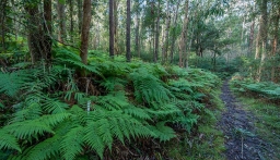
Ten Years of Blue Gum High Forest Protection
Sydney's Blue Gum High Forests built colonial Sydney. By the 1850s most had gone. However a few patches survived. The largest one was in St Ives. It was so rare, that Richard Dalrymple-Hay, NSW’s first Commissioner of Forests, acquired it as a demonstration forest. This became known as the Dalrymple-Hay Nature Reserve.
In 1934 Annie Wyatt – later to become the founder of the National Trust – led a community campaign to save this endangered forest.
Then again in 2007, the community led another campaign to acquire two privately owned blocks of land into public ownership and so protect the forest. To celebrate the tenth anniversary of this campaign, Friends of Ku-ring-gai Environment (FOKE) and STEP have organised some walks which highlight the beauty of Blue Gum High Forest and Janine Kitson is presenting a talk entitled The Battle of the Blue Gums.
FOKE Walk on Sunday 7 May – Dalrymple-Hay Nature Reserve
Time: 9:45 for a 10 am start (finish noon)
Meet: entrance to Dalrymple-Hay Nature Reserve (cnr Rosedale Road and Vista Street, St Ives)
Book: Janine Kitson (0428 860 623, 9498 2402, This email address is being protected from spambots. You need JavaScript enabled to view it.)
Nancy Pallin, one of the leaders of the campaign, will lead a walk demonstrating the unique features of this outstanding forest.
FOKE Walk on Sunday 14 May – Sheldon Forest from Turramurra to Pymble
Time: 9:45 for a 10 am start (finish noon)
Meet: ticket office, Turramurra Station
Bring: hat, water, snack and good walking shoes (involves walking up some steep hills)
Book: Janine Kitson (0428 860 623, 9498 2402, This email address is being protected from spambots. You need JavaScript enabled to view it.)
Sheldon Forest is one of Sydney’s rarest urban forests. It is within walking distance of not one, but two, railway stations – Turramurra and Pymble. The North Shore railway line forms a wildlife corridor that connects Sheldon Forest to other remnant forests in reserves and gardens. This ecologically focused heritage walk explores the unique relationship between the natural and built heritage of Ku-ring-gai and Sydney's forest history. It reveals layers of history – indigenous, colonial, federation, interwar, as well as revealing Australia’s rich biodiverse natural history. Discover why the resilience and protection of this magnificent Blue Gum High Forest is so important during a time of climate disruption and biodiversity extinction.
NPA Talk on Saturday 10 June – The Battle of the Blue Gums
Time: 10 to noon
Tutor: Janine Kitson
Book: https://www.weasydney.com.au/course/TBBG
During the 1930s, two forests were under threat – the Blue Gum Forest in the Blue Mountains and the Blue Gum High Forest in suburban Sydney. Discover how pioneer conservationists like Myles Dunphy and Annie Wyatt successfully rallied to protect these forests. How did these forest battles contribute to the modern Australian conservation movement? How are these forests faring today – at a time of burgeoning population increase, habitat loss and climate change?