
Newsletter blog
Children categories
Mountain Bikers Continue to Abuse the Environment
Ku-ring-gai Council’s decision to close the Warrimoo Downhill Mountain Bike Trail was taken in July 2016 (see STEP Matters 188). We all thought that this decision would be respected by the downhill bike riders given the strong reasons for its closure. We were wrong! This is not the only area that is being abused by these arrogant individuals. We recently discovered another track in Garigal National Park and have heard of many others. The details below explain why these cowboys must be stopped.
 Warrimoo Area
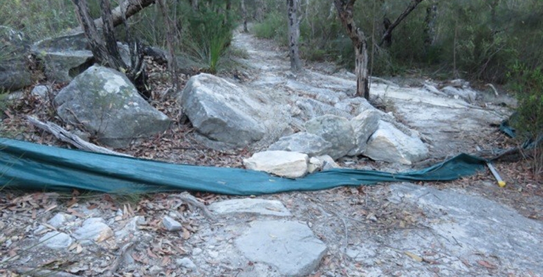
The track below Warrimoo Oval must have taken a lot of effort by several people to construct. It contains multiple jumps, ramps and curves as shown above and right. It could only be used by expert thrill-seeking riders. The independent report commissioned by council stated that the average decline is over 23% whereas the standard used for downhill trails is that they should be no more than 10%. Hence it is risky.
The major reason for closure is the ecological damage caused by the track construction and its continued use. The area contains an endangered ecological community called Coastal Upland Swamp and is also habitat for several threatened native birds, plants and animals. A STEP committee member who is a volunteer in a council-run Eastern Pygmy Possum monitoring project has observed threatened Eastern Pygmy Possums and Rosenberg’s Goanna. Under NSW and federal environmental laws, council is required to protect and conserve this ecological community and the native animals and birds that live within it.
The construction involved bush rock removal, clearing of native vegetation, removal of dead trees and wood, infection of native plants by Phytophthora cinnamomi and changes to landscape hydrology, which is adversely affecting the Coastal Upland Swamp and individual threatened species.
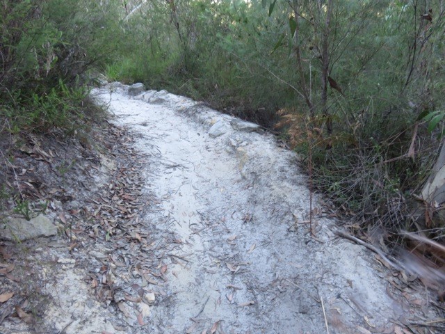
During a visit to the area just after the recent school holidays it was discovered that barriers and signs on the track installed by council had been shoved aside. The tyre marks along the track indicated that riders were still using the track. In 2016, council installed signs warning about video surveillance and explaining the reason for closure. These are being ignored.
This track and other downhill tracks are shown on some mountain biking websites encouraging this illegal use.
Following discussions with the local mountain bike community, council is working on options to reopen part of the trail that is south of the Coastal Upland Swamp. This involves completing an ecological feasibility study and consulting with an experienced mountain bike trail builder to see if suitable track modifications can be made with satisfactory ecological and safety outcomes. Given the steepness of the site and disturbance of the bushland reopening of the track is not guaranteed. The study will be completed by mid-2018.
Garigal National Park
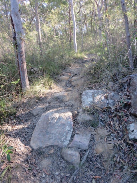 We have also discovered a new mountain bike track that has been carved through high quality bushland below Cambourne Avenue in St Ives down to Middle Harbour Creek. It takes a straight line down the hill while the legal management trail zigzags across the slope.
This is another area where threatened species have been found, namely the New Holland Mouse and also the Eastern Pygmy Possum.
Again a lot of work has gone into constructing ramps and jumps – see photo.
We encountered two riders who didn’t care that they were breaking the law and possibly causing untold damage to threatened fauna as well as their habitat, the bushland with large numbers of species providing food for these animals.
The law is that mountain bikes are allowed in national parks and council land on fire trails, roads and management trails and signage is provided to confirm that cycling is permitted.
These riders think their needs are too important for them to have to wait for the proper process of downhill track construction. This involves surveying plant and animal species that will be affected by bike riding. A route needs to be chosen that will cause minimal damage to the bushland and then a track is built that will be safe, resilient to weather and usage pressures. This process takes time and is expensive.
STEP is not happy about the two tracks that were built in the Frenchs Forest part of Garigal National Park, the Gahnia and Serrata tracks, because they traverse high quality bushland and their usage is likely to lead to introduction of pathogens and weeds and changes in hydrology. However the quality of construction means that their usage over the past two years has not caused any obvious damage so far. We understand that these two tracks cost over
$1 million to build.
Certainly there is a growing demand for mountain biking facilities and we should be encouraging participation in active outdoor sport like this but there are many trails available that can be used legally.
There is also a strong demand for the adrenalin rush of steep downhill rides but this must not be at the expense of damaging quality bushland that is already under attack from urban development and climate change (drought, bushfire). It is not as if the riders could possibly appreciate the bushland as they speed down a hill paying close attention to the next obstacle on the track.
NPWS needs the resources to prevent the construction of these illegal tracks.
What can we do?
The best we can do is alert the authorities, national parks rangers and council staff about any track we see when out walking in the bush. Also alert your local MP about your concerns and the need for more policing of illegal activities.
Wild Horse Heritage Act Condemned
Back in 2016 the NSW government conducted a consultation process on a Wild Horse Management Plan for Kosciuszko National Park (KNP). This was to be part of the Plan of Management for KNP. Based on the assessment of the ecological impact of the horse population its main objective was to reduce the total numbers of wild horses from the estimate of 6,000 down to 3,000 in 5 to 10 years and then to about 600 over a period of 20 years. The implementation of this plan is now impossible following the passing of the Kosciuszko Wild Horse Heritage Act 2018 on 6 June.
Why are Wild Horses a Problem in Alpine Areas?
The government’s website states plainly the reasons why wild horses should be removed:
Scientists have found that feral/wild horses can damage native environments in various ways:
- increasing soil erosion, by killing vegetation, disturbing the soil and creating paths along frequently used routes
- destroying native plants, by grazing and trampling
- fouling waterholes
- collapsing wildlife burrows
- competing with native animals for food and shelter
- spreading weeds, through their dung and hair
Feral/wild horses can also pose a biosecurity risk for spread of disease, as well as pose visitor and public safety risks such as on high speed roads and highways.
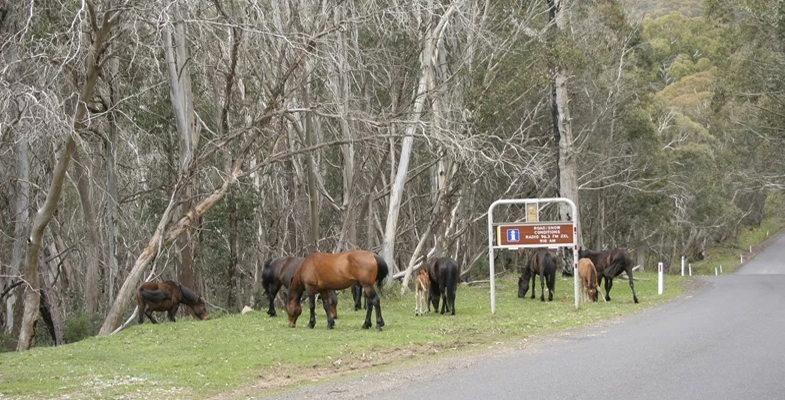
Wild horses grazing on the Alpine Way
The website is also frank about the controversy and emotion associated with community attitudes to horses in the national park:
NPWS refers to the horses as 'wild horses' in an effort to maintain balance between environmental and horse advocacy stakeholder groups that regard the terms 'brumby' or 'feral' as either romanticising or being derogatory, depending on the view point.
However it is pointed out that the NPWS:
… has a legal duty to protect native habitats, fauna and flora, geological features and historic and cultural features and values within the park … and has a responsibility to minimise the impacts of introduced species, including those of wild horses.
Key Threatening Process
In April 2018 the NSW Threatened Species Scientific Committee made a preliminary determination proposing that Habitat Degradation and Loss by Feral Horses, Equus caballus be listed as a Key Threatening Process in Schedule 4 of the Biodiversity Conservation Act 2016. Submissions close on 22 June.
As the determination explains:
- alpine and sub-alpine plants are slow-growing, recover slowly from disturbance and often occur in restricted areas;
- soils are fragile and the trampling disturbance caused by horses has negative impacts on a range of species, such as the vulnerable anemone buttercup Ranunculus anemoneus;
- sphagnum bogs (the principal known habitat for the endangered Northern Corroboree Frog, Pseudophryne pengilleyi) have an estimated growth rate of 3.2 to 3.5 cm / 100 years and are extremely sensitive to disturbance and trampling.
Also, many fauna species are sensitive to habitat disturbance and decreased water quality or availability. For example the critically endangered stocky galaxias fish faces extinction from trampling of their habitat.
Whether this determination, when finalised, will have any effect on horse management is now doubtful.
Brief History of Plans to Manage the Wild Horse Population
Since the current 2006 Plan of Management was implemented several reviews have been made of management plans for wild horses. Previous plans of action have proved to be ineffective in making any reduction in wild horse numbers. Trapping using lures and removal – the only method employed during the life of the 2008 Horse Plan – was costly, time consuming and did not effectively reduce the wild horse population. In addition, lack of demand for suitable domesticating (‘rehoming’) opportunities was an impediment. Often the trapped horses were in bad condition and had to be destroyed. The plan provided for aerial mustering but there would have been nowhere to send the horses. Shooting was not part of the plan.
The 2016 Plan of Management provided a comprehensive analysis of different parts of the KNP and defined strategies for a number of management zones to reduce the impact of wild horses. The techniques proposed included:
- mustering, trapping and removal from park for domestication or transport to knackery or abattoir
- trapping and culling on site if transport is not possible
- ground shooting
- fertility control
- fencing
For example the objective for the area south of Mt Kosciuszko towards Dead Horse Gap is to eliminate wild horses within five years while the aim for areas near the Victorian border east of the Alpine Way is to reduce the population as elimination would be impossible. There are other areas where horses are not present and the aim is to prevent them entering the area.
If the population increases there is an increased risk that they will enter more sensitive areas such as the Main Range. Plants in high altitude areas are currently recovering from sheep and cattle grazing that was stopped over 60 years ago.
NSW Government’s New Wild Horse Heritage Act
In a total bolt from the blue on 23 May the leader of the National Party and deputy premier, John Barilaro, presented a bill to the NSW parliament with an objective:
… to recognise the heritage value of sustainable wild horse populations within parts of Kosciuszko National Park and to protect that heritage.
The bill was passed by both houses of parliament on 6 June.
The act is very short on detail. It provides for the preparation of a wild horse heritage management plan for KNP. The draft plan is:
… to identify the heritage value of sustainable wild horse populations within identified parts of the park and set out how that heritage value will be protected while ensuring other environmental values of the park are also maintained.
There is a total conflict of interest here! There is no attempt to define heritage or what a sustainable population means. Do horses have more heritage than native animals? Is it sustainable from the point of view of the horse population only or within the context of the ecology of the whole KNP? The only opportunity for expert input to the draft is from the National Parks Wildlife Advisory Panel but only after the plan has been drafted.
The act will specifically prohibit shooting of wild horses in the national park. It will also limit any other management of wild horses to ‘highly sensitive alpine areas’ and such management will be limited to relocation and rehoming.
The act provides for the establishment of a Community Advisory Panel that will work on the draft plan but it has no requirement for representation by people with scientific qualifications in areas associated with the conservation of nature, nor does it require qualifications in cultural heritage research. It will include alpine tourism and horse riding operators. This arrangement will see scientific advice all but removed from the management of wild horses in KNP.
A major concern is that the act will prevail over the NSW National Parks and Wildlife Act 1974, Section 81(4), and will prevail over the 2006 Kosciuszko National Park Plan of Management, a legal instrument established under that act.
Strong Reaction to the Act
The passing of the act is another example of the NSW government’s disdain for national parks. The horse population will continue to increase. Do they see another tourism opportunity of more people trekking or horse riding in KNP to see wild horses? Perhaps these tourists will be horrified by the sight of starving horses and the damage they are doing as they search for edible grass?
Public condemnation has come from many directions:
- Australian Academy of Science wrote a letter stating the act placed ‘a priority on a single invasive species over many native species and ecosystems, some of which are found nowhere else in the world’
- Scientists from the United Nations body, the International Union for the Conservation of Nature wrote a letter to the environment minister Gabrielle Upton stating that ‘damage to the ecosystem and biodiversity values of the Kosciuszko national park would be detrimental to the reputation and status of Australia and NSW’s record for nature conservation’
- David Watson, an ecology professor at Charles Sturt University, resigned his membership on the NSW Threatened Species Scientific Committee citing the government’s wilful disregard for science
- RSPCA that worked on the 2016 plan as part of the expert panel said the act makes it impossible to conserve the unique environmental values of Kosciuszko as it will veto evidence based management
The only hope is for a change of government at the March 2019 election.
Relief as South Dural Development Proposal Withdrawn
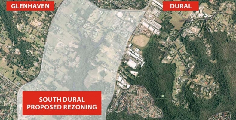
The South Dural proposal for rezoning and development of rural land has fallen through thanks in no small part to the 6,000 residents who wrote submissions and stood together to fight this inappropriate plan.
In 2013, developers Folkestone-Lyon lodged a planning proposal seeking the rezoning of 240 ha of rural land across South Dural, with almost 2,900 new homes to be built. About a quarter of the land to be developed contains high conservation value bushland including critically endangered Blue Gum High Forest. The plan resulted in community outrage and calls for major infrastructure upgrades before the proposal could be considered.
A peer review conducted on behalf of Hornsby Council identified technical gaps in the planning proposal, and the Planning Department recently announced that the proposal could no longer be supported, ‘due to the identified cost to government related to the provision of infrastructure’. Current road congestion is bad enough even before such a development were to be added.
Medium Density Housing Code Implemented with some Improvements

The NSW government has finalised the Low Rise Medium Density Housing Code and Design Guide that were the subject of consultation during 2016. This code allows one and two storey dual occupancies, manor houses and terraces to be built using the complying development approval pathway. Unless the type of development is not permitted in a residential zone under a council’s Local Environment Plan (LEP) a single dwelling can be redeveloped into 2, 3 or 4 dwellings depending on the size of the block. Design guidelines will have to be met but councils will not have control on the rate of take up of this opportunity.
The code is due to take effect in July but local concerns about congestion and over-development have become so great that the government was forced to defer implementation in four council areas. The deferral is only for a year however. This applies to Ryde, Lane Cove, Canterbury Bankstown and Northern Beaches but other councils are also asking for a deferral. Many areas of Sydney are struggling to cope with recent heavy development and infrastructure is inadequate. Is the one year deferral enough time to catch up?
Some councils, like Ku-ring-gai, already have provisions in their LEP that prevent this type of development in low density residential zones. Other councils want (and need) to be able to control the location of this infill housing option and are still working on a housing strategy that would define where this new category of development could occur. These are the councils that are asking for a deferral. They have just woken up to the potential consequences.
STEP’s submissions on this new type of complying development criticised the ad hoc nature of the application of the code and the broad implications of converting low density into higher density housing. There could be a huge rush of landowners taking up the opportunity to expand the value of their property. Councils need to able to specify areas where this type of development is not suitable, for example, because it does not fit in with the topography or character of particular areas or there is insufficient transport. At least the NSW government has recognised that councils need more control.
Design Guide Improvements
The Design Guide has been developed in partnership with the Government Architect’s Office, and aims to improve design by addressing layout, landscaping, private open space, light, natural ventilation and privacy.
The Design Guide has been improved by defining minimum standards for greenery on the blocks. The government has finally taken on board the importance of trees and gardens in reducing the heat island effect and improving local amenity. The guide specifies:
- minimum landscaped areas
- retention of trees especially along a boundary except where removal is approved by council
- planting of a tree in the front yard if the street setback is 3 m or more (mature height 5 m) and in the back yard (mature height 8 m)
- minimum soil volume to support the trees
- an ongoing maintenance plan
The ongoing question will be how that can these guidelines be enforced and the gardens kept alive. Councils will have a big responsibility perhaps?
Tree Bonds can help Preserve the Urban Forest
Great cities need trees to be great places, but urban changes put pressure on the existing trees as cities develop. As a result, our rapidly growing cities are losing trees at a worrying rate. So how can we grow our cities and save our city trees?
Tree bonds have recently been proposed by Stonnington City Council as a way to stop trees being destroyed in Melbourne’s affluent southeastern suburbs.
Tree bonds are a common mechanism for protecting trees on public land, but have so far had limited use on private land. A tree bond requires a land developer to deposit a certain amount of money with the local authority during development. If the identified tree or trees are not present and healthy after the development, the funds are forfeited.
The size of the bond can be established based on estimated tree replacement costs, and/or set at a level that is likely to achieve compliance (likely to be thousands or tens of thousands of dollars).
Why are trees important in cities?
The concept of an 'urban forest' includes all the trees and plants in cities. This includes tree-lined city streets as well as parks, waterways and private gardens. The urban forest contributes substantially to the quality of life of all urban dwellers, both human and non-human, and is increasingly used to adapt cities to climate change.
Trees cool the streets, filter the air and stormwater, and create a sense of place and character. They provide food and shelter for insects, birds and animals.
There is growing research evidence for the physical, mental and social health benefits of urban trees and green spaces. Many local councils such as Brimbank and Melbourne are investing substantially in tree planting to increase these benefits.
However, despite new tree planting on public land, tree canopy on private land is declining.
What can we do to protect trees?
There are a range of existing policy and land use planning measures focused on landscaping requirements for new development. Recently, the Victorian government introduced minimum mandatory garden area requirements. Some Melbourne councils, including Brimbank and Moreland, have also included planning scheme requirements for tree planting for multi-dwelling developments.
Other mechanisms for protecting urban trees on private land include heritage and environmental overlays within local planning schemes, and listings of significant trees and heritage trees.
However, penalties, monitoring and enforcement of tree protection bylaws have not kept pace with the pressures of urban change.
If penalties are insignificant relative to development profits, developers can easily absorb the costs. If monitoring is weak and removal has a good chance of going undetected, tree protection is more likely to be ignored. And if enforcement is weak, or there is a history of successful appeal or defeat of enforcement, many trees may be at risk of removal.
Even when it is successfully pursued, after-the-fact planning enforcement action is a particularly unsatisfactory recourse for tree removal. Replacement trees may take decades to match the quality of mature trees that were removed. What is needed, then, are mechanisms that prevent tree removal in the first place.
Increasing use of tree bonds
The advantage of tree bonds is that they place the onus of proof of retention on developers, rather than the onus of proof of removal on local councils. If a tree is removed, the mechanism is already in place to monitor (the developer needs to demonstrate the tree is still there) and penalise (the financial penalty is already with the enforcing body).
However, tree bonds still do not guarantee tree protection. Some mechanisms used to impose tree bonds may be vulnerable to challenge. For example, historically in Victoria, the planning appeals body VCAT has struck out conditions imposing tree bonds, arguing that punitive planning enforcement measures should be used where trees are removed.
Even where bonds can be imposed and enforced, developers may still be able to demonstrate that trees are unsafe or causing infrastructure damage, and thus need to be removed. In these circumstances, it is often hard to prove otherwise once the tree has been removed.
Nurturing an urban forest
Ultimately, if a landowner is hostile to a tree on their land, that tree’s health and survival can be imperilled, whether through illegal removal, neglect, or applications for removal based on health and safety grounds. It is therefore important that building layout and design realistically allow space for trees to flourish and be valued by landowners.
The urban forest needs protecting and enhancing. This calls for a range of policy mechanisms that work together to retain mature trees, maintain adequate spacing around them, and encourage residents to value and protect the trees around their homes.
![]() Tree bonds provide an attractive solution for local governments in the absence of a strong land use policy framework for protecting trees.
Tree bonds provide an attractive solution for local governments in the absence of a strong land use policy framework for protecting trees.
Joe Hurley, Senior Lecturer, Sustainability and Urban Planning, RMIT University; Dave Kendal, Senior Lecturer in Environmental Management, University of Tasmania; Judy Bush, Postdoctoral Research Fellow, Clean Air and Urban Landscapes Hub, University of Melbourne, and Stephen Rowley, Lecturer in Urban Planning, RMIT University
This article was originally published on The Conversation. Read the original article.
New Project to Investigate Sterilising Woody Weeds to Stop Seed Spread
With the recent introduction of the Biosecurity Act, there is now more emphasis to think about our action in terms of weed spread and dispersal. The act specifically focuses on the shared liability relating to containment and control of weeds.
There is a significant and unresolved conflict between the retention of trees of species that are invasive and ecologically-damaging but are also recognised for their cultural, historic or aesthetic significance.
Camphor Laurel is one such species. They were planted extensively for amenity or cultural reasons but the species readily invades natural areas, impacting on biodiversity and ecosystem functions. Individual trees can generate copious progeny annually through seed production and dispersal.
Killing such trees will certainly stop seed set but this may result in community angst. There are instances where the removal of such trees is curbed by community or historic values. Protestors may only have their thoughts on a few issues, such as shade or the loss of very old picturesque trees, however we must consider that the seed from some of these invasive species may be transported long distances via birds and deposited in other areas.
Is it possible to preserve these trees whilst preventing them from producing seed?
Chemicals can be used to Modify Growth
We are all too familiar with herbicides and their primary role to kill weeds. However, there are many herbicides that have been used to modify the growth of plants without the aim of death. Other active ingredients (non-herbicides) have also been identified to alter plants growth for a desired outcome.
New Project
A federally funded project commenced in July 2017, courtesy of the Department of Agriculture and Water Resources and the lead agency MidCoast Council and other collaborating agencies. The primary aim was to undertake some research in the following two years to scope a handful of chemicals to de-flower or prevent fruit from developing on African Olives and Camphor Laurels. There is potential to use this technique, if successful, on other species. However, as there is limited project time it was decided to stay focused on these species.
African Olive
African Olive is a garden escape plant and has become a serious weed in bushland. It can further spread to and heavily impact upon agricultural land. More than 4,000 hectares of dense African Olive infestation has been identified across the western Sydney region alone. African Olive was listed as a key threatening process to biodiversity by the NSW Scientific Committee in 2010.
It is estimated that African Olive is having a negative impact on at least 25 endangered ecological communities as well as 13 threatened flora and 4 threatened fauna species in NSW. African Olive has further been listed in the Global Invasive Species Database. African Olive out-competes established native vegetation, casting dense shade which prevents the regeneration of native plants. Infestations can alter the floristic structure and habitat value of remnant bushland areas.
Camphor Laurel
Camphor Laurel is considered a threatening weed under similar listings to African Olive. They have the ability to adapt to the disturbed environment, have prolific seed production and a rapid growth rate as well as a lack of serious predators or diseases, they also possess many specific attributes which enhance its weed status.
Camphor Laurels are ecosystem changers. They have a tendency to form single species communities and exclude most other tree species, including desirable native vegetation. They have a very dense, shallow root system which, when accompanied by the shading provided by the canopy, suppresses the regeneration of native seedlings. They have the ability to replace and suppress native vegetation and have an allelopathic effect on other species.
Interim Results from Year 1
The list of potential chemical candidates for testing was rather lengthy and after an extensive literature review the list was trimmed down to three chemicals for Camphor Laurels and two for African Olives. Growth habit of the weed plays a large role into determining the type of treatment selected and how it is applied. A species like African Olive is often multi-stemmed and would be impractical for stem injecting whereas the single stemmed Camphor Laurel trees are ideal for a range of chemical deliver systems.
A long dry period of weather from winter to spring played havoc on the flowering times and synchronicity of Camphor Laurels and African Olives. Fortunately significant rains fell in early October to rejuvenate the weeds, however flowering was still not ideal. Timing of treatments was closely linked to flowering, namely near early-mid flower bud opening stage.
Assessment of treatment impacts on flowering or fruiting capacity of the weeds was undertaken in March and May 2018, but careful consideration was made to foliage changes. An ideal treatment is one that suffers no foliar damage while completely aborting reproductive issue.
The interim results from the African Olive experiments suggest this species is rather difficult to selectively control flowering/fruiting without severely affecting foliage.
The best compromise appeared to be treatment A with two times concentration that reduced fruit setting by 90% with a foliage damage score of 3 out of 10 which equates to some very noticeable symptoms from which the plant will take some time to recover. Four times concentration reduced fruit setting by 98% but with much more severe foliage damage. There is scope to apply various rates around this two times rate in the second year of the project, to better fine tune treatment outcomes.
It appears treatment A (same treatment for African Olives) was the most suitable for temporarily sterilising Camphor Laurels. It subtly made the foliage paler whilst significantly reducing reproductive capacity. Treatment B achieved very little. Treatment C will be tested in year 2 at much lower rates due to excessive foliage damage in year 1.
Concluding Comments
The second and last year of testing will be focused on getting consistency and robustness of the likely treatments that may be considered for registration or permits. The key to success is developing a treatment that can be easily and evenly applied that doesn’t leave obvious scarring of bark while achieving near perfect seed set control and barely noticeable effects on foliage. Timing of treatments could be investigated in subsequent projects, however there is only enough time to investigate rate responses of treatment A.
Fingers crossed for a better season than 2017-18.
This is a shortened version of an article in the Autumn 2018 edition of A Good Weed, the newsletter from the NSW Weed Society. Here’s hoping this idea can be extended to many more weed species, in particular privet.
Ku-ring-gai BioBlitz

 The iNaturalist website has been set up as a means for citizens and scientists worldwide to record their observations of wildlife. It includes a system for verification of species photographs by other members.
A local 15-year-old has used his initiative to raise awareness of the great biodiversity in our region by setting up a local BioBlitz group. You can post any nature sightings made around Sydney, as well as improve your knowledge of the local flora and fauna and meet like-minded nature enthusiasts near you.
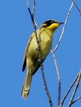
He organised a BioBlitz from 14 to 15 April in Ku-ring-gai Chase National Park. Nine people participated who recorded 185 observations of 112 species. The most notable observation by a couple of STEP members was a Yellow-tufted Honeyeater.
John Martyn’s New Book, Rocks and Trees
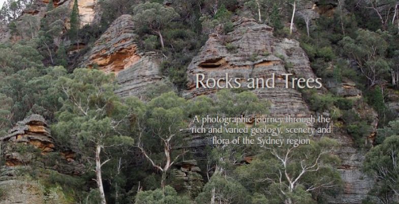
The perfect way to learn about the geology that underpins the landscape and diverse flora of the Sydney region
A photographic journey through the rich and varied geology, scenery and flora of the Sydney region
Rocks and Trees captures the dramatic scenery of the Greater Blue Mountains, the beauty of the coastline and the great sweep of plains west of the CBD, but its main purpose is to highlight the geology and flora and their interrelationships. The book journeys from the Illawarra along the coast to Newcastle and inland to the Greater Blue Mountains, staying within the framework created by the massive sandstones and conglomerates of the Triassic Narrabeen Group.
Canoon Road Saga Continues

There has been much local angst about the idea that lights be installed on some of the Canoon Road netball courts to allow matches on one evening and practice on three other evenings. STEP made a detailed submission highlighting the potential environmental impacts. Other submissions focussed on the lack of information about traffic and noise impacts and consideration of alternative sites.
In order to progress the situation, Councillor Jeff Pettett put up a motion at the meeting on 13 March for further studies to be completed particularly to consider additional suitable court locations. It is essential that other locations are considered to reduce the burden on Canoon Road and the travel required on congested roads. We hope a satisfactory solution will be found soon.
Biodiversity Laws Court Case

The Nature Conservation Council with the help of the Environmental Defenders Office won the case challenging the process of implementation of the land clearing codes.
The court decision was an opportunity for Premier Berejiklian to amend the bad laws her government had implemented and make some key improvements to protect habitat.
Instead, she has chosen to stick rigidly with the same destructive laws and ignore the science that highlighted the likely destruction. By the government’s own assessment, they will lead to a spike in clearing of up to 45% and expose threaten wildlife habitat to destruction, including 99% of identified koala habitat on private land.
Vale Noel Rosten
All members of the local botanical, bushcare and conservation communities have been deeply saddened by the sudden death of Noel Rosten on 26 February when he was knocked down by a car outside his letterbox. He was aged 85. The following details about his vibrant life have been taken from the tributes made by the Australian Plant Society (North Shore Group) and Hornsby Council.
Noel was an active member of many community groups within Hornsby Shire which included the Friends of Berowra Valley, Hornsby Conservation Society and the Australian Plant Society (APS). In the wider community, he was active with Easycare Gardening, National Tree Day and Clean Up Australia Day. He joined the Hornsby Council Bushcare program in 1992 and ended up running three bushcare groups.
Above all he loved bushwalking and growing native plants. With his wife, Rae, he joined APS North Shore Group in 1985. He and Rae developed a spectacular garden where Noel propagated native plants and orchids, many of which were donated for sale by the APS.
In the mid-1990s Noel and other members formed the Hornsby Herbarium to collect specimens of all the vascular plants in the Hornsby Shire. Once a week they went bush, listing all native plants on the track and collecting specimens for identification or scanning. These records now form the backbone of Hornsby Council’s herbarium.
Noel was a keen and talented photographer. He regularly entered the bushcare photograph competition with high quality photographs, many of which have been used in the bushcare calendar.
He was quiet, funny, gentle, always helpful, always willing to patiently share his knowledge He leaves a tremendous conservation legacy.
Members of STEP offer their condolences to Rae, their children and to Noel’s family and friends.
Native Forest Protections are Deeply Flawed, yet May be in Place for another 20 Years
Regional Forest Agreements (RFAs) are the mechanism by which the states are permitted to log native forest under accreditation from the Commonwealth. The RFAs were designed not just to exploit this public resource but to incorporate conservation and recreation. They have a number of explicit aims such as establishing a reserve system to ensure adequate protection for forest ecosystems and threatened species, an ecologically sustainable logging process and to provide long-term stability for the forestry industries.
The National Parks Association (NPA) published a report in 2016 (OF Sweeney, Regional Forest Agreements in NSW: Have they Achieved their Aims?) that was highly critical of the RFA system. It said:
… the RFAs have failed to substantially meet their goals either wholly or in part.
and recommended that the NSW government should transition away from native forest logging.
As explained in the article below, the Australian government is planning to roll over 20-year extensions of the RFAs without any review as to the current ecological status of forests or reference to new information since the RFAs were first signed 20 years ago.
During the period provided for submissions on the renewal of RFAs the NPA was attacked by the Assistant Minister for Agriculture and Water Resources, Senator Anne Ruston claiming deliberate dishonesty in their campaign to end public native forest logging in NSW.
CEO of the NPA, Alix Goodwin has stated that:
It’s hard to see the senator’s letter as anything but an attempt to intimidate us, because we successfully challenged the government’s efforts to rush the RFAs through with minimum scrutiny.
The following article was written by Professor David Lindenmayer from the Fenner School of Environment and Society, ANU and was published in The Conversation on 23 March 2018.
State governments are poised to renew some of the 20-year-old Regional Forest Agreements (RFAs) without reviewing any evidence gathered in the last two decades.
The agreements were first signed between the federal government and the states in the late 1990s in an attempt to balance the needs of the native forest logging industry with conservation and forest biodiversity.
It’s time to renew the agreements for another 20 years. Some, such as Tasmania’s, have just been renewed and others are about to be rolled over without substantial reassessment. Yet much of the data on which the RFAs are based are hopelessly out of date.
Concerns about the validity of the science behind the agreements is shared by some state politicians, with The Guardian reporting the NSW Labor opposition environment spokeswoman as saying 'the science underpinning the RFAs is out of date and incomplete'.
New, thorough assessments are needed
What is clearly needed are new, thorough and independent regional assessments that quantify the full range of values of native forests.
Much of the information underpinning these agreements comes largely from the mid-1990s. This was before key issues with climate change began to emerge and the value of carbon storage in native forests was identified; before massive wildfires damaged hundreds of thousands of hectares of forest in eastern Australia; and before the recognition that in some forest types logging operations elevate the risks of crown-scorching wildfires.
The agreements predate the massive droughts and changing climate that have affected the rainfall patterns and water supply systems of southwestern and southeastern Australia, including the forested catchments of Melbourne.
It’s also arguable whether the current Regional Forest Agreements accommodate some of the critical values of native forests. This is because their primary objective is pulp and timber production.
Yet it is increasingly apparent that other economic and social values of native forests are greater than pulp and wood.
To take Victoria as an example, a hectare of intact mountain ash forests produces 12 million litres more water per year than the same amount of logged forest.
The economic value of that water far outstrips the value of the timber: almost all of Melbourne’s water come from these forests. Recent analysis indicates that already more than 60% of the forest in some of Melbourne’s most important catchments has been logged.
The current water supply problems in Cape Town in South Africa are a stark illustration of what can happen when natural assets and environmental infrastructure are not managed appropriately. In the case of the Victorian ash forests, some pundits would argue that the state’s desalination plant can offset the loss of catchment water. But desalination is hugely expensive to taxpayers and generates large amounts of greenhouse emissions.
A declining resource
Another critical issue with the existing agreements is the availability of loggable forest. Past over-harvesting means that much of the loggable forest has already been cut. Remaining sawlog resources are rapidly declining. It would be absurd to sign a 20-year RFA when the amount of sawlog resource remaining is less than 10 years.
This is partially because estimates of sustained yield in the original agreements did not take into account inevitable wood losses in wildfires – akin to a long-distance trucking company operating without accident insurance.
Some are arguing that the solution now is to cut even more timber in water catchments, but this would further compromise water yields at a major cost to the economy and to human populations.
Comprehensive regional assessments must re-examine wood supplies and make significant reductions in pulp and timber yields accordingly.
The inevitable conclusion is that the Regional Forest Agreements and their underlying Comprehensive Regional Assessments are badly out of date. We should not renew them without taking into consideration decades of new information on the value of native forests and on threats to their preservation.
![]() Australia’s native forests are among the nation’s most important natural assets. The Australian public has a right to expect that the most up-to-date information will be used to manage these irreplaceable assets.
Australia’s native forests are among the nation’s most important natural assets. The Australian public has a right to expect that the most up-to-date information will be used to manage these irreplaceable assets.
David Lindenmayer, Professor, The Fenner School of Environment and Society, Australian National University
This article was originally published on The Conversation. Read the original article.
Image: Current protections for native forests are hopelessly out of date. Graeme/Flickr, CC BY-NC
Foreign Donations Bill is a Threat to Democracy

The Australian government proposal, first floated in 2016, to remove tax deductibility status from donations to environment groups unless they use at least 25% of their donations for on the ground works has fizzled out. But now there is a new threat with a much broader reach, the Electoral Legislation Amendment (Electoral Funding and Disclosure Reform) Bill 2017. This so-called ‘foreign donations bill’ has been introduced in the name of protecting Australian politics from foreign influence. This poorly constructed bill would devastate the work of charities across the board if it goes ahead.
It is a great idea to limit foreign donations to political parties but this bill, as drafted, will have other much broader consequences for democracy in Australia. It could shut down the voices of community advocates, impose burdensome red tape restricting their work and it could severely limit the ability to do research and provide information to assist the general public to understand or participate in public debate.
All organisations that spent $100,000 or more on political activities in any of the previous four years would have to register as a ‘political campaigner’. Political expenditure is broadly defined and includes the expression of ‘any views on an issue that is, or is likely to be, before electors in an election’ whether it is during the campaign period or not. The cost of many charities’ advocacy on issues including homelessness, the age pension, low wages, refugees and the environment would be deemed political expenditure, forcing them to register.
The new status of ‘political campaigner’ comes with requirements to keep records to ensure donors of more than $250 pa are ‘allowable donors’ – such as Australian citizens or residents – and are not foreign entities. To comply donors would have to complete a statutory declaration and have it signed by a justice of the peace. It would be nigh impossible for groups to track individual donations and then ask for a statutory declaration. In any case many donors are likely to not bother. Other red tape requirements include the nomination of a financial controller that is liable for the charities’ disclosures, and the disclosure of the political affiliations of senior staff.
For donations from non-citizens or non-residents, charities would have to set up special accounts to keep revenue separate from other sources and ensure it was not spent on political expenditure. Breaches of these rules could trigger fines of more than $50,000.The ultimate effect for charities will be a set of complex, cumbersome and costly administrative requirements.
An example of an organisation that would be affected is the World Wildlife Fund that has over a number of years been strong advocates for Australia leading on conservation measures in the Antarctic. Their ability to advocate for that cause is only possible in large part because of funding from international donors and they will be restricted or banned from doing that.
Constitutional law experts have warned that the law is likely to be unconstitutional
Postscript
There has been a strong campaign against the proposed law from charities in all spheres. On 10 April the Senate electoral committee released a bipartisan report with 15 recommendations related to the bill. Notably, they called for the Australian government to rewrite parts of its foreign donations bill, which would remove some of the contentious elements related to charities funding. If these recommendations are agreed the bill will still create new obstacles for charities speaking out for the people they represent. Charities are still calling for the bill to be totally redrafted.
New Alliance to Push for Strong National Environment Laws

Australia’s rate of species decline continues to be among the world’s highest. Government decisions to promote population growth and resource exploitation (mining and agriculture) are accelerating this trend. Often governments are able to ignore their obligations to protect and conserve threatened species because of weak national environment laws. Governments are reversing hard fought gains as evidenced by recent decisions to relax land clearing laws in NSW and the reduction in marine sanctuary protections.
Australia’s environment protection laws are not working. An alliance of environment groups has been formed to push for a total revision of the federal laws and administration systems to stem the trend of loss of biodiversity and degradation of the environment. Leadership is needed at the federal level to ensure a coordinated approach. Maybe under the current coalition governments the chances of this being achieved are low but the approach provides guidelines for a way forward.
Places You Love Alliance
This alliance, called the Places You Love, has been created by 40 national groups guided by the work of the Australian Panel of Experts on Environmental Law. The Alliance follows the principles of collective action to achieve greater outcomes for nature than could be achieved by a single organisation.
Birdlife Australia, a member of the Alliance published a report in February 2018 called Restoring the Balance: The Case for a New Generation of Environmental Laws in Australia. In the foreword Nobel Laureate Prof Peter Doherty states:
Even when there is strong scientific evidence of actions that will cause harm, Australia’s poor record of environmental monitoring coupled with the ambiguity of key terms in legislation such as ‘significant impact’ means that science can effectively be ignored. Worse still, in some cases our Federal Minister has the power to use his or her discretion to override scientific evidence. Under exemptions, such as Regional Forest Agreements, actions that will impact on threatened species don’t even require Federal approval.
The Federal Environment Protection and Biodiversity Conservation (EPBC) Act was passed in 1999. It is meant to be the key piece of legislation that ties together the roles of the Australian government and the states in order to create a truly national scheme of environment and heritage protection and biodiversity conservation The Act focuses Australian government interests on the protection of matters of national environmental significance, with the states and territories having responsibility for matters of state and local significance.
The matters of national environmental significance cover international obligations such as RAMSAR wetlands, nationally threatened species and ecological communities, Commonwealth marine areas, the Great Barrier Reef and water resources in regard to coal seam gas and major coal mining developments.
There are many inherent weaknesses in the Act and its implementation, meaning many neglected threatened species are simply being left to decline. Here are some examples.
Carnaby’s Black-Cockatoo

Federally listed as endangered, the Perth-Peel subpopulation of Carnaby’s Black-Cockatoos has declined by more than 50% since 2010, due to the ongoing clearing of foraging and roosting habitat on the Swan Coastal Plain. With more than 70% of banksia woodland now cleared, the species has become increasingly reliant upon pine plantations north of Perth to survive. But these are allowed to be harvested and are not being replaced.
Birdlife Australia has reported several times the decline in population and quoted legal advice that the continuing removal of mature pine plantations was in breach of the EPBC Act Recovery Plan and met the requirement for a significant impact on a matter of national environmental significance. The WA government has failed to take action demonstrating the inherent weakness in the legislation that relies in a large part on self-referral, opaque definitions of what constitutes a ‘significant impact’ and insufficient resources to ensure enforcement and compliance.
Swift Parrot
The Swift Parrot is critically endangered. With fewer than 1,000 pairs left in the wild, it is predicted to go extinct in the next 14 years. Loss of breeding habitat in Tasmania through logging and clearing that is allowed under RFAs is one of the greatest threats to the parrot’s survival, along with predation by introduced Sugar Gliders.
Unlike other industries whose activities may have a significant impact on nationally listed threatened species, logging and clear felling ‘in accordance with a RFA’ is exempted from national environment protection laws. In the absence of strong national leadership, recovery actions taken in one jurisdiction may be undermined by destructive practices in another.
Regent Honeyeater
The Regent Honeyeater is nationally critically endangered, having declined by more than 80% over the last three generations. Its decline is linked to clearance and degradation of its woodland habitat. The Lower Hunter Valley is known to be important for Regent Honeyeaters and is predicted to become even more important as climate change intensifies. Unfortunately, the woodlands and forests of the Lower Hunter are under significant threat from mining, industrial and urban developments.
In 2007 the Australian government approved development within the Tomalpin Woodlands. More recent evidence shows that this area is vital breeding habitat and there are other places where the industrial development could occur. The federal environment minister could but is not compelled to act on this new evidence.
Recovery Plans
When the EPBC Act was first passed into law, the listing of a species as nationally threatened triggered a legal requirement for the development of a national recovery plan; a document that captures current understanding of how present and past threats contributed to the species’ decline and the key actions needed to recover the species. While such plans are not directly enforceable, one would think the plan should impose measures to help protect a species, for example by identifying areas of critical habitat that must be protected. Importantly, the environment minister cannot approve an action that is inconsistent with a recovery plan.
In the five years or so following the introduction of the Act, a number of recovery plans showed clear intent to use the full powers and provisions of the Act but over time, recovery plans have become increasingly insipid as governments have sought to avoid strong prescriptions that might limit activities within a species’ range or require resources for the implementation of priority actions.
As the lists of threatened species have grown, funding for the development and implementation of plans has declined. Today, most listed species don’t have recovery plans. For those that do, recovery plans were mostly drafted long ago and have not been updated within the required five-year time frame.
Wish List of Reforms
The Alliance is calling for the reforms outlined below. However it is hard to imagine that they could be countenanced by the current government.
1. Create national environment laws that genuinely protect Australia’s natural and cultural heritage
The current system distributes responsibility across the federation, but no one jurisdiction is charged with coordinating efforts to protect our environment. A lack of nationally consistent monitoring and reporting makes evidence-based decision-making difficult for governments and increases costs for businesses attempting to comply with eight different, often-changing regulatory regimes.
The Australian government must retain responsibility for current matters of national environmental significance and protect them effectively. But national oversight currently is too limited and must be expanded to cover broader issues that impact on biodiversity and ecosystems such land clearing and water extraction.
2. Establish an independent National Sustainability Commission to set national environmental standards and undertake strategic regional planning and report on national environmental performance
The commission would also develop enforceable national, regional, threat abatement and species level conservation plans. Central to a new national environmental protection framework is the timely collection and disclosure of environmental data and the provision of independent and transparent advice on planning and approval decisions.
3. Establish an independent National Environmental Protection Authority that operates at arm’s-length from government
The authority’s role would be to conduct transparent environmental assessments and inquiries into development proposals as well as undertake monitoring, compliance and enforcement actions.
4. Guarantee community rights and participation in environmental decision making
Australian citizens have a right to be involved in decisions that will affect the use and health of our environment. Communities have been shut out or ignored by decision makers. Too often this has led to conflict between businesses and communities, and weakened community trust in government processes and institutions.
Hopes for Marine National Parks Protection Slashed
It has been a long drawn out process to develop a National Representative System of Marine Protected Areas (NRSMPA). In 1998 the commonwealth, states and Northern Territory governments committed themselves to establishing the NRSMPA by 2012. The Australian government affirmed this commitment at the United Nations World Summit on Sustainable Development in 2002.
The states are responsible for managing coastal waters out to 3 nautical miles offshore. Beyond that marine management is the Australian government’s responsibility.
The primary goal of the NRSMPA is to establish and effectively manage a comprehensive, adequate and representative system of marine reserves to contribute to the long-term conservation of marine ecosystems and to protect marine biodiversity.
After extensive consultation and scientific analysis the Gillard government declared a new network of marine reserves and plans of management that took effect in November 2012. The reserves cover 36% of Commonwealth waters with various levels of protection.
At the time there were protests from fishing industries but it was estimated by the Australian Bureau of Agricultural and Resource Economics and Sciences that only around 1% of the total annual value of Australia's commercial fisheries would be displaced.
The Abbott government came into power in September 2013 and in December suspended the declarations and management plans for these new reserves and instituted another review claiming that the science in the previous review was inadequate.
Draft revised plans from this review was released in 2017 and in March 2018 the final decision was announced by Environment Minister Frydenberg.
All the fears of the marine scientists that the science would be ignored have been realised. The draft proposals are to be implemented despite the protests exemplified by the statement below.
Government Decision
The government claims that the amended policy is a balanced and scientific evidence-based approach to ocean protection. However the marine conservation groups, such as Save Our Marine Life and WWF, have condemned the reductions in protection levels. In their view a particularly insidious form of partial protection is that of ‘habitat protection zones’ whereby only activities that affect the seabed are excluded. Such zoning ignores the important biological links between animals in the water column and the seabed. It allows commercial fishing activities within the marine parks that have already been assessed as incompatible with conservation in the government’s own risk reports. Indeed, such zoning creates the opportunity for industrial scale fishing within our marine parks by vessels such as the imported Dutch super trawler, the Geelong Star, that so many Australians rejected.
Sadly the Senate passed the new management plans on 27 March. Labor and the Greens could not marshal enough support from the independents to oppose the plans.
The following is a statement from the Ocean Science Council of Australia, an internationally recognised independent group of university-based Australian marine researchers, and signed by 1,286 researchers from 45 countries and jurisdictions, in response to the federal government’s draft marine parks plans.
We, the undersigned scientists, are deeply concerned about the future of the Australian Marine Parks Network and the apparent abandoning of science-based policy by the Australian government.
On 21 July 2017, the Australian government released draft management plans that recommend how the Marine Parks Network should be managed. These plans are deeply flawed from a science perspective.
Of particular concern to scientists is the government’s proposal to significantly reduce high-level or 'no-take' protection (Marine National Park Zone IUCN II), replacing it with partial protection (Habitat Protection Zone IUCN IV), the benefits of which are at best modest but more generally have been shown to be inadequate.
The 2012 expansion of Australia’s Marine Parks Network was a major step forward in the conservation of marine biodiversity, providing protection to habitats and ecological processes critical to marine life. However, there were flaws in the location of the parks and their planned protection levels, with barely 3% of the continental shelf, the area subject to greatest human use, afforded high-level protection status, and most of that of residual importance to biodiversity.
The government’s 2013 Review of the Australian Marine Parks Network had the potential to address these flaws and strengthen protection. However, the draft management plans have proposed severe reductions in high-level protection of almost 400,000 square kilometres – that is, 46% of the high-level protection in the marine parks established in 2012.
Commercial fishing would be allowed in 80% of the waters within the marine parks, including activities assessed by the government’s own risk assessments as incompatible with conservation. Recreational fishing would occur in 97% of Commonwealth waters up to 100km from the coast, ignoring the evidence documenting the negative impacts of recreational fishing on biodiversity outcomes.
Under the draft plans:
the Coral Sea Marine Park, which links the iconic Great Barrier Reef Marine Park to the waters of New Caledonia’s Exclusive Economic Zone (also under consideration for protection), has had its Marine National Park Zones (IUCN II) reduced in area by approximately 53% (see map below)
six of the largest marine parks have had the area of their Marine National Park Zones IUCN II reduced by between 42% and 73%
two marine parks have been entirely stripped of any high-level protection, leaving 16 of the 44 marine parks created in 2012 without any form of Marine National Park IUCN II protection
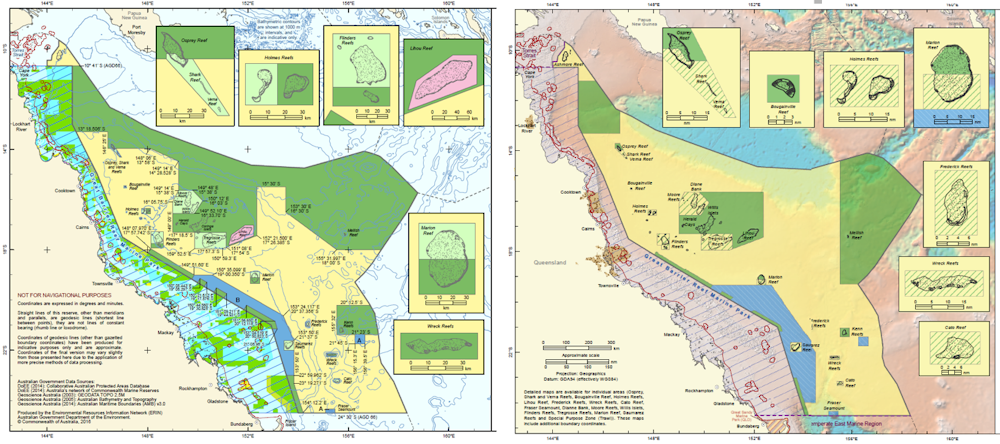
Proposed Coral Sea Marine Park zoning, as recommended by independent review (left) and in the new draft plan (right), showing the proposed expansion of partial protection (yellow) vs full protection (green). From http://www.environment.gov.au/marinereservesreview/reports and https://parksaustralia.gov.au/marine/management/draft-plans
The replacement of high-level protection with partial protection is not supported by science. The government’s own economic analyses also indicate that such a reduction in protection offers little more than marginal economic benefits to a very small number of commercial fishery licence-holders.
Retrograde step
This retrograde step by Australia’s government is a matter of both national and international significance. Australia has been a world leader in marine conservation for decades, beginning with the establishment of the Great Barrier Reef Marine Park in the 1970s and its expanded protection in 2004.
At a time when oceans are under increasing pressure from overexploitation, climate change, industrialisation, and plastics and other forms of pollution, building resilience through highly protected Marine National Park IUCN II Zones is well supported by decades of science. This research documents how high-level protection conserves biodiversity, enhances fisheries and assists ecosystem recovery, serving as essential reference areas against which areas that are subject to human activity can be compared to assess impact.
The establishment of a strong backbone of high-level protection within Marine National Park Zones throughout Australia’s Exclusive Economic Zone would be a scientifically based contribution to the protection of intact marine ecosystems globally. Such protection is consistent with the move by many countries, including Chile, France, Kiribati, New Zealand, Russia, the UK and US to establish very large no-take marine reserves. In stark contrast, the implementation of the government’s draft management plans would see Australia become the first nation to retreat on ocean protection.
Australia’s oceans are a global asset, spanning tropical, temperate and Antarctic waters. They support six of the seven known species of marine turtles and more than half of the world’s whale and dolphin species. Australia’s oceans are home to more than 20% of the world’s fish species and are a hotspot of marine endemism. By properly protecting them, Australia will be supporting the maintenance of our global ocean heritage.
The finalisation of the Marine Parks Network remains a remarkable opportunity for the Australian government to strengthen the levels of Marine National Park Zone IUCN II protection and to do so on the back of strong evidence. In contrast, implementation of the government’s retrograde draft management plans undermines ocean resilience and would allow damaging activities to proceed in the absence of proof of impact, ignoring the fact that a lack of evidence does not mean a lack of impact. These draft plans deny the science-based evidence.
We encourage the Australian government to increase the number and area of Marine National Park IUCN II Zones, building on the large body of science that supports such decision-making. This means achieving a target of at least 30% of each marine habitat in these zones, which is supported by Australian and international marine scientists and affirmed by the 2014 World Parks Congress in Sydney and the IUCN Members Assembly at the 2016 World Conservation Congress in Hawaii.
![]() You can read a fully referenced version of the science statement here, and see the list of signatories here.
You can read a fully referenced version of the science statement here, and see the list of signatories here.
Jessica Meeuwig, Professor and Director, Marine Futures Lab, University of Western Australia
This article was originally published on The Conversation. Read the original article.
Tree Frog Apartments Available – Free!

We gardeners are often urged to ‘buy native’, especially nectar-producing flowering shrubs like grevilleas and banksias – they attract birds of course, even if these days mostly noisy miners and lorikeets. But a native species that's not for every garden but carries hidden gems is the Swamp Lily Crinum pedunculatum.
This is not a true lily but a member of family Amaryllidaceae, like Agapanthus and Clivea. It can be found in the wild, fringing coastal lagoons, and if you came on the Wyrrabalong walk you may have seen them scattered along the shoreline of Tuggerah Lake. They're also common at Maitland Bay in damp ground protected behind the beach dunes.
They are a large lily-like plant with a sheath of very long, broad, spear-shaped, scooped leaves around a solid, fleshy base. We've had one in the garden for about 20 years and you'd need a bobcat and a couple of big guys to transplant it. Ours usually puts up three spikes of large, faintly perfumed, purple-streaked, creamy white flowers in summer.
The scooped leaves collect pools of water at their bases that last for several days after rain and tree frogs seem to have no difficulty finding them. Two days out of three you can see one to three cute little Peron's Tree Frogs Litoria peronii snuggled into the soggy leaf pockets – we get them in all sizes and subtly varying buff-brown shades so a number of different individuals come and go; and also tiny, green Eastern Dwarf Tree Frogs Litoria fallax turn up on occasion.
Other inhabitants include crickets, huntsmen spiders and snails, and probably other creatures we don't see who come and go at night or when we're not looking. Another tree frog species, Litoria verreauxii, could also turn up, and I'm still tuning up my frog i.d. skills to pick the differences – colours can vary quite a bit.


Left: Peron's Tree Frog Litoria peronii in its temporary garden home. A noisy neighbour!
Right: Dwarf Green Tree Frog Litoria fallax on Swamp Lily leaf
Even if you don't have any Swamp Lilies in your garden you may still have suitable plants. A friend finds them in her bromeliads, though I don't know which sort. Gymea Lilies are a possibility too, as are other amaryllids – in fact almost any lily or sheath-like plant that retains water after rain is worth checking. And I imagine having more unusual natives like swamp lilies helps the survival of such moisture loving creatures through our long dry spells.
PS Swamp Lilies, like other amaryllids, are very prone to attack by Spodoptera caterpillars. Swarming with their longitudinal stripes they can eat a plant right down to the ground in a couple of weeks. It will recover via its rootstock but it doesn't look great in the meantime.
Written by John Martyn
Despite the dry weather there have been other frog encounters – the banner photo at the top of the page is a Green Stream Frog (Litoria phyllochroa) found on the Darri Track by Helen Logie.
STEP History – A Mapping Retrospective
The preparation of STEP’s history by Graeme Aplin and the committee is progressing well and will be completed by our 40th anniversary celebration on 22 July. This has given us an opportunity to reflect on the work that went into the development of our walking maps and the tremendous contribution of our volunteers. Below is an outline of the history and process of production of our maps.
There is still a regular demand for the STEP maps. Their broad coverage and detail make it possible to plan connections with public transport and interesting variations on the standard routes.
First Lane Cove Valley Map
It all started in the 1980s when a group of South Turramurra locals decided that a map was needed of the STEP Track and other local tracks. They went out checking the tracks that had been created over the years by various authorities and locals who found their own way to explore the bush. There was no national park in those days. They often met people who welcomed the idea of formal printed map. So this was the beginnings of the first Lane Cove Valley map that was printed in 1990 but it had a long gestation period of about 8 years.
The first draft was developed by geographer, Graeme Aplin and then Margaret Booth and the team of South Turramurra locals marked out the tracks which were then verified by a team of volunteers. This map covered the area upstream from De Burghs Bridge.
The final cartography and printing was done by the Central Mapping Authority in Bathurst and the Paddy Pallin Foundation provided a loan to cover printing costs.
The map was launched by Tim Moore, the State Minister for the Environment as a prelude to a bushwalk on 19 August 1990.
2000 and 2016 Lane Cove Valley Maps
In late 1997 the committee decided that a revision was needed because most copies had been sold, and changes had been caused by the 1994 bushfires and the M2 motorway. This time the map was extended to cover the whole Lane Cove River valley down to Greenwich Point. The map was launched in November 2000 by Peter Duncan, Director of the Centennial Park and Moore Park Trust.
John Martyn’s experience as a geologist was vital for the creation of the base map. Many hours or work were involved in building a full-colour base map stitched together from digital files provided by the NSW Lands and Property Information, air photos, satellite images and field observations. Roads, national park boundaries, local parks, hazards, natural features and many other details were meticulously inserted. Then the tracks were added and checked by John and a team of volunteers. Some volunteers did this with GPS and for wider tracks by Google Earth and air photos, others by simple navigation.
By 2015 it was realised that the map was getting out of date again. We had a good base to work on with the previous map. However John decided to extend the map detail to the west and south-west to cover more of the Lane Cove River catchment and more opportunities for walking connections with railway stations on the northern line. It is amazing how much has changed over 15 years so this again was a major exercise. Often it is harder to check for changes than to start from scratch!
It would not be possible to produce both maps without the help of our volunteers. Their work is much appreciated. Their names are listed below but please excuse us if any names are left out as it was hard to keep track of them all:
- 2000 map – Phil Helmore, Ralph Pridmore, Jenny Schwarz, Peter and Robin Tuft, Natalie Wood, Helen Wortham.
- 2016 map – John Booth, Debbie Byers, Robert Carruthers, Jill Green, John Hungerford, Adrienne Kinna, Andrew Lumsden, Ruaridh MacDonald, Natalie Maguire, Alan McPhail, Ralph Pridmore, Jim Wells, Natalie Wood, Ted Woodley.
Middle Harbour Maps
It became evident in the early 2000s that the Middle Harbour catchment offered numerous walks over a much larger area, and also that many STEP members who are keen walkers also lived in or near that catchment. Given the experience with Lane Cove mapping it seemed an easy choice to create bushwalking maps of that area. It also followed creation of Garigal National Park which merged large council bushland areas into one entity. The map coverage included a considerable area of suburbs carrying small reserves and linking larger bushland reserves, and included popular harbourside walks too, many in Sydney Harbour National Park. The end result was two double-sided sheets extending from Mona Vale Road to Greenwich and North Head.
The base for the Middle Harbour catchment was purchased from Lands and Surveys digital database and they also carried out the printing.
Volunteers were John Balint, Therese Carew, Bill Filson, Tim Gastineau-Hills, Gerald Holder, Simon and Joy Jackson, Bill Jones, Jan Kaufman, Kate Read, Jennifer Schwarz, Peter Tuft and Natalie Wood. STEP was also supported by the late Bill Orme, Graham Spindler and Leigh Shearer-Herriot (North Sydney Volunteer Walkers Group), NPWS and the relevant councils. Map cover pictures were watercolours by artist Janet Carter of East Roseville.
Children’s Threatened Species Art Competition

STEP was a sponsor of this competition last year. Over 1,600 children entered and created some brilliant art works.
The 2018 Threatened Species Children’s Art Competition will be open for entries between 4 June and 3 August 2018. Children from 5 to 12 years old are invited to unleash their creativity while learning about our threatened species.
Each child chooses one of over 1000 threatened species, researches, and then draws or paints it, and writes a short explanation of their work. Photographs of artworks and written explanations can be submitted on-line. Fifty finalists will be chosen for an exhibition in Sydney in September, with winners announced at Parliament House Sydney on 7 September, Threatened Species Day.
Citizen Science Opportunities

FrogID is a project to help identify and survey frogs in your area. This is done via an app on your phone whereby you can record the frog call, note your location and this information is sent off and collated. This is run through the Australian Museum.
STEP is turning 40 this year

Our plans to celebrate STEP’s 40th anniversary will be announced later this year. Graeme Aplin has kindly offered to write a history of STEP from those heady days of the battles against the development of the Canoon Road netball complex and the Lane Cove Valley freeway. Graeme’s academic background in the environment and history makes him eminently qualified for the task.
If you have any STEP stories or photographs that you would like to share please contact us at This email address is being protected from spambots. You need JavaScript enabled to view it..
Surprise Proposal to Increase use of Lighting at Canoon Road Netball Complex – Bad for Players and Locals
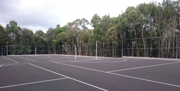
The Plan of Management of the Canoon Netball Complex was amended in 2015. It involved improvements to landscaping and changing the location of some courts and car parks. A consultative committee comprising representatives from the local community, netball players and council officers was to review the operation of the complex and in particular consider the recommendation that lighting be installed to be operated on Thursday and/or Friday evenings between 5 and 7.30 pm for some matches during the winter netball season. The aim was to reduce the problems on Saturdays of traffic movements.
The contentious plan for lighting had not been progressed until in November 2017 Ku-ring-gai Council passed a motion that recommended a change to the Plan of Management so that lighting would be operated on four nights per week on nine courts from 4.30 to 8 pm.
The closing date for submissions was 1 February. Click here for STEP's submission.
Environmental Impact
STEP opposes the plan for any lighting on the grounds of environmental impact. Basically the night lighting does not conform to the objective of the Plan of Management:
… to minimise the impact of Canoon Road Recreation Area upon the adjoining bushland and the Lane Cove River catchment.
The complex is located on a high ridge so that the lighting will spill over the surrounding bushland and Lane Cove River conservation areas. No details are available of the specifications for the lights but they will need to be high and strong to be fit for purpose.
The bushland area is habitat for several threatened species, many of which are nocturnal such as the Powerful Owl. The minimum requirements for large forest owls are that lighting should be directed away from, and not interfere with, nest and breeding roost trees. Diurnal animals may extend their activity well beyond normal sunset but nocturnal animals may be particularly affected due to their eyesight, actual and feared predation, and reduced breeding success.
Traffic Impact
Apart from the environmental issues there are other reasons to oppose the plan. No comprehensive traffic study has been completed that considers the additional traffic that would impinge on the Kissing Point Road/ Comenarra intersection during the busy evening period.
We question whether netball players will want to battle with evening traffic to get to and from Canoon Road. Traffic along the Pacific Highway near Turramurra crawls every afternoon. Surely players and their parents would prefer training to be near where they live. Also it has not been proven that the removal of one age group from the Saturday matches will make a significant difference to Saturday congestion.
Netball is different from other sports in that the playing area is smaller so that there are many more players using a sporting area compared with sports like soccer or baseball. The changeover time between matches involves double the number of car movements. The submission from the Kissing Point Progress Association points out that night matches could generate about 500 car movements per hour to peak hour traffic.
Better Solutions?
Council needs to find a broader solution to the provision of netball facilities. Participation will only increase as our population grows. The concentration of the sport in the narrow isolated location is not satisfactory for such a popular sport. It is not fair to the players and their parents. An effort should be made to find alternative sites for matches and training throughout Ku-ring-gai and Hornsby.
The original plan for the North Turramurra Recreation Area included four lit netball courts but for some unknown reason this has not been implemented. There are plans to upgrade other park areas. The NSW government has plans to upgrade facilities at some schools that could include lighting of courts. Some possible sites could even be accessible by public transport! In theory there are buses that go near the Canoon Road complex but they get stuck in traffic!
Container Deposit Scheme is now up and Running

At the last Clean Up Day the largest number of items collected by far was beverage containers (about 30% of items). Here’s hoping this situation will show improvement since the Return and Earn, as the Container Deposit Scheme is now called, started on 1 December.
As at 4 February, over 65 million containers have been collected. Many of these would have been previously in council collections. Containers can be returned to receive 10 cents per container or the refund can be donated to a charity. The price of drinks has gone up of course, mostly by 15 cents.
Click here to find a collection point near you and for more information about the types of containers that can be returned. Currently there is one in Ku-ring-gai and five in Hornsby.
Local Wildlife

Good insulation in a tree hollow or a well ventilated drey provides better protection than a nest box on a hot December day. Sleeping outside to stay cool is always dangerous.
The male wasn't very active and obvious through midsummer though he had up to two or more females at a time around in the spring. This is possibly his second/last chance: the season finishes soon; maybe Valentine's Day is the big day.
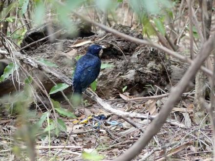
Mr Bowerbird perches proudly above his toy car collection (about 2 m from his bower)
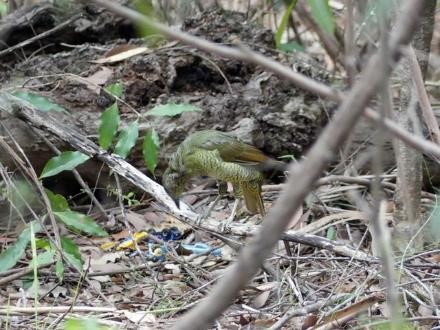
Mrs is not so impressed and thinks he needs some upmarket models – maybe a toy Lamborghini?
I found it difficult to get a good description of an actual nest, either on-line or in bird books, but the WIRES site says the female alone builds and lays in a nest 10 to 15 m up in a tree, and raises the young, while the male goes on and courts other females in his bower. I'll scan the trees for a nest next time I'm out there.
I think one can be sure that this ‘female’ is truly a female, but a young male's colouring is apparently similar and it only turns satin blue-black at 5 to 7 years old, so if you see a stray ‘female’ around, as you often do, then it could easily be a young of either sex.
I'm always blown away by the violet-coloured eye, particularly against the green background of the female, though these pictures don't do it justice.
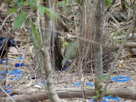
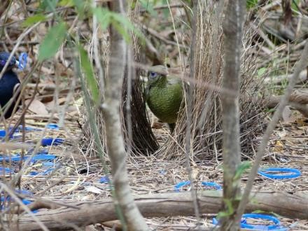
I think Mrs is tidying up while Mr wants to add even more blue plastic and make an even bigger display (mess?)
Michele Cooper leaves LCNP
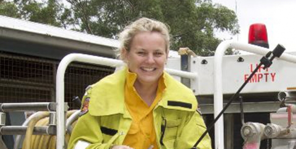
The last two issues of STEP Matters (Our National Parks Need Protection and Fifty Years of the NPWS but is Anyone Celebrating?) have described the savage treatment being applied by the NSW government by cutting national parks funding and staff restructuring. This is despite a huge increase in the popularity of parks revealed in a regular survey undertaken by the NPWS. Since 2014 the number of visits to NSW national parks by Australian residents has increased from 39.1 million to 51.8 million, a massive 32% in just two years.
The significance of the restructuring policy has been brought home by the loss of Michele Cooper who has been Lane Cove Valleys Area Manager for five years. This profile of Michele has been written by Tony Butteriss, President of the Friends of Lane Cove Valley.
Friends is very disappointed to hear that Michele Cooper has not been reappointed to her role in the restructure of NSW National Parks and Wildlife Service. We will miss her professionalism, advice and personality. We wish Michele the most for her future and as she said recently, ‘we have so much more to do and achieve, I want another 50 years’.
Outgoing Area Manager, Michele Cooper came from an interesting background. She arrived at Lane Cove River Area as a ranger in 2001. Her degree is in physical geography with a master in limestone cave management but she insists she gained her skills on the job. She managed the Pennant Hills additions, Dalrymple Hay Nature Reserve (her favourite spot) and the Kukundi Wildlife Shelter.
The value of Lane Cove National Park – according to Michele – is in having pockets of bushland within a massive metropolitan city. She values her staff and the volunteers that are dedicated to environmental work. Her typical workday is diverse, needing her attention across a range of tasks: a school group wanting a tour ... what spider is this … can I run an event with 3,000 people … a tree fallen over a track … where can I go camping? And of course – bush fires.
Her special achievement at NPWS was her Aboriginal Tour Guide Training Manual. It trained Aboriginal people to give tours in national parks. After she led the first training program, TAFE and NPWS ran numerous courses using the manual. Since then some land councils have used her manual to set up tour guide businesses.
Before Michele joined NPWS, she taught whale rescue skills to NPWS staff at the Quarantine Station on North Head. She got on so well with staff that they asked if she would volunteer. She joined NPWS doing fauna surveys in western NSW in the mid-1990s. Her next job was gate-collector for Ku-ring-gai Chase National Park. She returned to western NSW for 10 years conducting fauna surveys off-park on lands that were viable for adding to the reserve system. In Sydney, Michele was a ranger and also regions community relations officer before becoming area manager for Lane Cove. We have just lost a manager with over 25 years of highly commendable work with NPWS.
Vale Harold Spies, Founding Member of WEPA

It is with great sadness that Willoughby Environmental Protection Association (WEPA) reports the peaceful passing of long-term member, Harold Spies, in Castlecrag on 18 December at the age of 97.
Harold was a founding member of WEPA and active on its executive for over 35 years. In that time he provided inspiration and sage advice on a wide variety of WEPA policies, campaigns and projects and was always on hand to plan campaigns, write for and produce the newsletter, lead walks, work on bush regeneration projects and to man WEPA’s many stalls.
WEPA was formed in 1982 by a group of local residents concerned about the quality and management of the environment. WEPA works for the protection and improvement of Willoughby’s environment through effective planning, management and maintenance, both locally and beyond. Their activities include regular talks, bush restoration projects, making submissions and holding plant stores.
Final Outcome of Trial of Hunting in National Parks

It seems a long time ago when the NSW public were fighting an attempt in 2013 by the Shooters and Fishers Party, supported by the NSW government, to allow amateur hunters into national parks. Hunting has been permitted in state forests since 2002 but there was much more at stake with national parks. There was strong opposition on many grounds particularly its effectiveness in removing feral animals.
Ultimately the government decided to scale back the proposal and do some proper research on ground shooting as a method of controlling feral animal populations. In 2014 it instituted a trial of hunting in six park areas mostly in central and western NSW that contained threatened species and ecological communities. The trials were to be scheduled and managed by the NPWS.
The final report by the Natural Resources Commission into the trial of the so-called Supplementary Pest Control (SPC) was released in February 2017.
The SPC trial has shown that using appropriately trained and capable volunteer ground shooters can deliver positive pest management outcomes and social benefits, such as improved relationships and communication between NPWS and their neighbours. The trial has also demonstrated that volunteer ground shooting can be done safely and humanely when sufficient risk management, supervision and planning are undertaken. The Commission has concluded that volunteer ground shooting has the potential to be an effective supplementary pest control technique in the state’s national parks and other reserves, if used as part of an integrated pest management program under controlled conditions.
The Commission recommended that the SPC program be continued with it being strategically applied where it can provide most benefit as part of an integrated pest management program. The Commission also recommended that additional funding be allocated separate from NPWS core pest management budget. A happy ending to a sorry saga.
Appeal to Stop Development that will Destroy the Bayview Wildlife Corridor

 Northern Beaches Council is currently considering a development application that has been submitted to build 95 seniors housing units, three to four storeys high in seven buildings on open space land at Bayview Golf Course. Construction will lead to the chopping down of more than 100 trees that are the core of a High Priority Coastal and Wildlife Corridor.
The corridor allows wildlife movement between the coast at Winnererremy Bay, Mona Vale and major habitat areas around Katandra Bushland Sanctuary and Nangana Road, Bayview. It is habitat for threatened and vulnerable species including a pair of Powerful Owls, glossy black cockatoos and a colonies of microbats and the Bent Wing Bat.
Under the Planning Policy for senior’s housing development a site compatibility certificate (SCC) is required to be issued by the Department of Planning before the development application can proceed. It confirms that the development is broadly compatible with the surrounding environment and locality. The department must consider a series of criteria covering environmental, resources, servicing and infrastructure and local impacts before making a decision.
A previous SCC application made in January 2015 was knocked back by the department on the grounds that:
- the height and scale are out of character with surrounding residential character
- the site is flood prone land and no evidence has been provided that the development will not adversely affect surrounding land uses
- there are significant environmental implications for existing flora and fauna including threatened species and adjacent wildlife corridor.
The same SCC application was submitted in April 2017 and this time it was approved.
A report on restoring habitat for threatened species has recently been completed. The report found that vegetation patch area and wildlife corridors have the strongest positive effects on biodiversity when complemented by vegetation structure. Large sites greater than 30 ha are necessary to prevent a rapid loss of area-sensitive species.
Update on Hills Council Plans for IBM Site

STEP Matters issue 193 provided detail on the application by Mirvac to build 600 apartments in the former IBM business site next to Cumberland State Forest. In addition to the IBM site Mirvac owns a large land area that currently contains high quality bushland.
Hills Shire Council applied to the Department of Planning for a Gateway Determination to allow rezoning of the bushland part of the 28 ha site for R4, high density. The department issued the Gateway Determination on 31 October telling the council to do more homework and amend the zoning plan to provide protection of the high value vegetation.
Lo and behold, Hills Council then wrote a letter to the department on 12 December 2017 requesting an amendment to the Gateway Determination to permit zoning of the high quality bushland as E3, Environmental Management. This would allow the area to be subdivided into 2 ha lots with the associated need to bushfire protection zones, roads, water supply, etc all leading to the destruction of endangered ecological community and threatened species habitat.
Mirvac has advised in writing that they want the area zoned as E2, Environment Conservation, and they are not seeking to impose the cost of this protection on the council. So all the community groups opposed to the development are at a loss to understand why council applied for E3.
Council has also applied for special conditions in the DCP for just this site that are different from the rest of the Hills Council LEP. It also requests the removal of the 2.5 ha recreation zone, saying it could create public open space. Why not commit to providing open space that will be essential for the new residents?
They have requested approval for site specific provisions which would enable a single developer, Mirvac, to build a completely ‘new type of housing’ which has been built nowhere else in the Hills Shire, on 86 m2 blocks, in a zoning which provides for 700 m2 lots.
We await the next decision by the department. Go to www.forestindanger.org.au for the latest news and how to make a submission to council or the Department of Planning.
Is the Federal Government Really Concerned about Biodiversity?

The Australian government has a framework of strategies and programs for the management of biodiversity. According to the Department of Environment and Energy, Australia’s Biodiversity Conservation Strategy 2010–2030 guides how governments, the community, industry and scientists manage and protect Australia's plants, animals and ecosystems.
The recent review of the strategy is puzzling. A well-defined program seems to have been thrown out the window in its implementation but some parts of it are working well such as the Threatened Species Action program.
The Australian Conservation Foundation and WWF Australia recently released their joint submission on the 2018–19 budget. This revealed that the Australian government has slashed environment spending by one-third since 2013. This cut in spending is one of the reasons for the sorry record in maintaining biodiversity.
State of the Environment reports document the extent of the problem. For example, between 2011 and 2015, there was a 66% increase in the number of critically endangered animals (from 38 in 2011 to 63 in 2015) and a 28% increase in critically endangered plants (112 in 2011; 143 in 2015). By critically endangered, we mean that extinction is a real possibility in the short term for these species. Immediate action is needed if we are to avoid terminating millions of years of independent evolution, as these biological lineages die out.
2010 Biodiversity Strategy
The Australian government first developed a biodiversity strategy in 1996. An update was made in 2010. It is intended to provide a guiding framework for all levels of government to conserve our national biodiversity over the next 20 years.
The document is comprehensive, comprising 100 pages. It provides an overview of the state of Australia’s biodiversity and outlines collective priorities for conservation. The vision of this strategy is that Australia’s biodiversity is healthy and resilient to threats, and valued both in its own right and for its essential contribution to our existence.
The strategy identifies three national priorities for action to help stop the decline in Australia's biodiversity:
- engaging all Australians in biodiversity conservation
- building ecosystem resilience in a changing climate
- getting measurable results
The strategy contains 10 interim quantified national targets for the first five years.
Five Year Review of the Strategy
A review of the first five years of the strategy was released in 2016.
The review report is very critical of the strategy but to my mind the main reason is that not enough effort has gone into its implementation. For example it is criticised for being long and technical but also for providing inadequate guidance for decision makers to determine how best to direct investment for biodiversity conservation. That detail would have made the document much longer and even more technical. There is confusion in the review between the roles of the strategy and the programs to implement action.
New Strategy – How can they be Serious?
On 25 November 2016, Australian, state and territory environment ministers agreed to revise the 2010 strategy taking into account the findings of the five year review.
Called Australia’s Strategy for Nature 2018–2030: Australia’s Biodiversity Conservation Strategy and Action Inventory, the draft revised strategy is open for public comment until 16 March 2018. Click here to make a submission.
In response to the review the government has thrown out the baby with the bath water. The Department of Environment and Energy’s website states:
The strategy has been revised to improve its ability to drive change in biodiversity management priorities, and its alignment with Australia's international biodiversity commitments.
How can that be? The 100 page document has been replaced by one with 17 pages. There is a complete absence of actions, only statements about what could be done.
Vision
The vision of the new draft is that:
Australia’s nature, now and into the future, is healthy and resilient to threats, and valued both in its own right and for its essential contribution to our health, wellbeing, prosperity and quality of life.
Basically unchanged from the previous strategy.
How much information can be contained in a 17 page document that uses up lots of pages in preambles and background?
The goals are simplistic to say the least; that is:
- to connect people with nature
- to care for nature
- to build and share knowledge
The priorities in meeting these goals as described are all text book stuff. They could be applied to any country. There is nothing specific to Australia’s characteristics and biodiversity situation. As usual with the current governments there is no mention of climate change.
Here are three quotes to give an idea of the lack of specifics:
Objective 3. Increase understanding of the value of nature
Australians understanding of the value of nature, and its role in health and wellbeing can be improved through increasing children’s learning about nature, encouraging organisations and businesses to report their performance against environmental measures, or using environmental accounts to more clearly demonstrate the value of nature.
Objective 8. Use and develop natural resources in an ecologically sustainable way
… Sustainable use and management of natural resources can be achieved through strategic planning and trade-offs between use and protection …
Objective 10. Increase knowledge about nature to make better decisions
There are opportunities to target research to reduce gaps in knowledge and improve management strategies, to support development and implementation of innovative tools and techniques, and to build connections between the environmental disciplines and social sciences …
Is there any Action Guidance?
The draft strategy devotes one whole page to the proposed actions but there is no proposed action. The proposal is for governments to develop an ‘action inventory’, a giant database that will illustrate efforts that ‘contribute to the strategy’s goal and objectives’. The content of this one page then goes on to suggest what information might be included and who might find the inventory useful:
It is a concept for testing and discussion. The online capabilities, content and timelines for an action inventory are yet to be finalised and will be informed by this consultation process.
Threatened Species Action
The biodiversity document is puzzling when there are examples of successful action. In 2015 the government launched a threatened species strategy and promised to make it a priority. The year one report card showed that 21 of the 26 objectives in that report were achieved. The targets and actions were clearly defined and included tackling feral cats and fox-baiting programs. Certain species were identified for action to improve their population numbers and habitat. This contrasts with the overall biodiversity strategy that should be focused on actions that reduce the risks of more species becoming threatened such as land clearing and increasing the reserve system.
The government doesn’t seem to know what to do about our loss of biodiversity or are they just totally disinterested?
Quick Response to Loss of Trees in Hornsby

In the previous issue of STEP Matters we reported on the major loss of trees in Hornsby Shire in recent years and the commissioning of a report by council outlining options to strengthen tree protection measures to re-establish Hornsby’s tree canopy.
In December council put forward a draft amendment to the tree preservation provisions of the Development Control Plan. The amendment, if enacted, would make the tree preservation order similar to the rules that apply in Ku-ring-gai. Council approval would be required for the removal or significant pruning of all trees except listed weed species.
This a major turnaround from the current situation where trees can be removed except if they are on the list of local indigenous species or in a heritage area.
Submissions closed on 26 January. We hope the amendment will be adopted promptly.
Tree Disputes are much the same now as 65 Years Ago

In the last newsletter we highlighted the loss of tree canopy in Hornsby Shire and illustrated the abrupt decrease in tree canopy from Ku-ring-gai Chase National Park to the urban area along Harwood Avenue, Mt Kuring-gai.
An article on page 1 of the Sydney Morning Herald on 24 December 1952 shows emotions ran as high then as they do now.
Dispute over Trees: Gun Threat Charge
Mr John Richardson, 76, a well-known Mt Kuring-gai resident, was charged at Hornsby Petty Sessions yesterday with assaulting Mr AJ Cresswell, the Kuring-gai shire engineer, by threatening him with a gun.
He was remanded until January 9 on £20 bail.
Mr Richardson’s arrest followed a dispute at Kuring-gai yesterday morning when shire council workmen, supervised by Mr Cresswell, were uprooting trees in High Street, near
Mr Richardson’s property.
Mr Richardson, a retired engineer, lives with his family in a large old house, the grounds of which are a show place in the district.
The disputed trees are just outside his property on the corner of High Street and Railway Street, and frame a vista across Cowan Creek Valley.
About nine months ago, after Hornsby council employees had sent bulldozers to clear land further south, local residents protested at the destruction of trees.
Once, ratepayers’ wives stood in front of some to prevent their destruction.
An agreement was eventually reached with the council by which selected trees were spared.
The trees about which yesterday’s dispute arose were saved temporarily by the protests of Mr Richardson and neighbours, who telephoned the shire president, Councillor Somerville. Councillor Somerville assured the residents that the trees would be spared.
There is a sharp division within the community between the ‘pro-tree’ and ‘anti-tree’ elements.
The ‘pro-tree’ element contends that only by sharp vigilance have they prevented Mt Kuring-gai from becoming denuded.
Mr Richardson said last night:
‘A lot of new people are coming to this neighbourhood who want to cut down everything. They are vandals.
‘The trees are being removed to-day give us shelter. They protect us from southerly gales.’
After Mr Richardson had been released on bail, the police offered to drive him home.
Mr Richardson said he preferred to go by rail.
But at Hornsby Station he got on the wrong train – a non-stop train to Gosford. He had to spend several hours there before catching a train back.
https://trove.nla.gov.au/newspaper/article/18296287
This news item was followed by a letter from the Shire President on page 2 of the Herald on Saturday 27 December 1952.
Trees at Hornsby
Sir, The report in Wednesday’s ‘Herald’, headed Dispute Over Trees, did not present the case fairly from Hornsby Council’s point of view.
Some time ago council provided a street light at the intersection of High Street and Railway Street, Mt Kuring-gai, and later undertook some clearing of the roads, having regard to the residential development which has taken place in that locality.
Complaints were received from many of the residents, who in some cases are young folk, that the scrub and undergrowth at this point presented a hazard at night, first in that it prevented the street light from efficiently illuminating the intersection referred to, and secondly, provided a harbourage for any undesirables.
As president of the shire, I instructed the Electrical Engineer Manager to personally supervise the tidying up of this corner and to remove only any under scrub and rubbish which helped to obscure the light. The statement attributed to me that I said ‘the trees would be spared’ is not in accordance with fact. My statement was that only those trees or undergrowth which it was found absolutely necessary were to be taken out. No trees whatever of any dimension nor of any beauty were interfered with.
Hornsby Council over the years has been most tree conscious and has many miles of roads and streets, and also parks within its boundaries planted with trees which are now reaching maturity, and during the current year carried out tree planting for a total length of over one mile. It has always been council’s policy to retain trees to the fullest extent even when road construction works and the extension of electric light and telephone services are proceeding, and in cases where removal of some trees has been absolutely essential others have been planted in close proximity to replace them.
C.H. Somerville, Shire President, Shire of Hornsby
https://trove.nla.gov.au/newspaper/article/18296440
The fight was all in vain as shown in the aerial photos below and above.
Mt Kuring-Gai 11 years before this dispute (1941). Many trees are present at this intersection and across the eastern side of Mt Kuring-gai. The individual tree canopies are small and presumably indigenous trees such as Eucalyptus haemastoma (Scribbly Gum) various Stringybarks and Corymbia gummifera (Red Bloodwood). 4138 Map 1310 156-5/417 Broken Bay Run 12 1941.
The photo at the top of the page illustrates how the fight to save these trees was all in vain as during the 1970s this intersection was removed for construction of the M1. In 2017 there appears to be generally fewer trees but with larger canopies than in 1941. Aerial view from SIX Maps, accessed 2017.
Robin Buchanan wrote this item. She must have a very good filing system to be able to find the newspaper cuttings!
Going to Ground: How used Coffee Beans can help your Garden and your Health

Did you know that your morning cup of coffee contributes to six million tonnes of spent coffee grounds going to landfill every year? This does not have to be the fate of your caffeine addiction and there are many opportunities to up-cycle spent coffee grounds into valuable commodities.
From fresh fruit, to roasted bean, to used up grounds, coffee’s chemical composition offers a range of uses beyond making your daily brew.
Potential applications range from biofuels, to health products, and fertiliser for farms or your garden. So why are we throwing this precious product away?
The answer is that processing and production can be more complex than you might imagine – even when we’re talking about simply using coffee grounds in your garden. What’s more, many recycling initiatives to turn waste coffee into valuable commodities are still in their early stages.
You may have noticed that some cafes now offer free spent coffee grounds for customers to take home and use in the garden. In theory, this is a great initiative but the reality is that fresh coffee grounds are high in caffeine, chlorogenic acid and tannins that are beneficial to humans but toxic to plants.
The spent coffee must be detoxified by composting for a minimum of 98 days for plants to benefit from the potassium and nitrogen contained in the roasted beans. Without adequate composting, the benefits are scant (see below). So if you do take some coffee grounds home from your local cafe, make sure you compost them before sprinkling them on the veggie patch.
The good news is that properly composted coffee grounds offer a cheap alternative to agro-industrial fertilisers, potentially helping urban communities become greener and more sustainable. Savvy businesses have begun processing coffee grounds on a commercial scale, turning them into nutrient-rich fertilisers or soil conditioners in convenient pellets for use in the garden.

But why stop there? A potentially even more valuable ingredient is the chlorogenic acid. Although toxic to plants, as mentioned above, chlorogenic acid has potential as a natural health supplement for humans, because of its antioxidant, anticancer and neuroprotective properties.
The whole coffee production process is abundant in chlorogenic acid, particularly in raw coffee beans. Chlorogenic acid conversion efficiency is even better from green coffee pulp, with a 50% recovery rate, compared with 19% for spent coffee grounds.
As undersized and imperfect beans are discarded at this raw stage, many businesses have seized the opportunity to market green coffee extracts as a weight loss product, although more research is needed to confirm this potential.

The list doesn’t end there. Coffee waste can be used to create a diverse list of chemicals, including enzymes and hormones for digestion of common biological compounds and to improve plant growth; and feedstocks for high-end crops such as mushrooms. Coffee oil has even been trialled as a fuel for London buses.
![]() With abundant waste supplies due to the popularity of coffee consumption, by recycling the byproducts, perhaps we can enjoy one of our favourite beverages without too much guilt.
With abundant waste supplies due to the popularity of coffee consumption, by recycling the byproducts, perhaps we can enjoy one of our favourite beverages without too much guilt.
Tien Huynh, Senior Lecturer in the School of Sciences, RMIT University
This article was originally published on The Conversation. Read the original article.
Talking Energy, a Summer Barbeque Guide

Here are five common Australian energy myths and facts for the next barbeque when these questions about renewable energy are raised. The information comes from the Climate Council.
Myth 1: What happens when the sun doesn’t shine and the wind doesn’t blow?
Fact: Renewable energy and storage can provide electricity 24/7
Renewable electricity can power the economy through a mix of wind and solar energy, together with on-demand renewables (such as solar thermal, biomass or hydro power) and energy storage (such as pumped hydro or batteries). Improved energy efficiency and demand response, such as installing modern appliances and ensuring these appliances are not running when electricity demand is high, can also help make the grid more reliable.
Myth 2: Coal is reliable
Fact: Ageing coal generators are unreliable and vulnerable to heatwaves
The Australian Energy Market Operator (AEMO) has identified ageing coal power stations as a risk to reliable electricity supply. By 2030, most of Australia’s coal fired power stations will be over 40 years old. Once the coal fleet reaches this age, they become increasingly expensive to run, and increasingly unreliable particularly during heat waves.
This is a major management problem for AEMO. The aged Liddell power station in the Hunter Valley whose life the Turnbull government wants to extend has had multiple turbine breakdowns this summer. Each unit is large so a breakdown has a significant impact on the total power available.
Myth 3: Renewable energy is driving up electricity prices
Fact: Renewable energy is the cheapest form of new power
New renewable energy is driving down electricity prices by increasing electricity supply. Australia’s coal power stations are reaching the end of their lives and need replacing. Renewable power from wind and solar farms is the cheapest form of new power generation and is best suited to replace these old clunkers. More than 1.6 million Australian households are reducing their electricity bills with rooftop solar.
Myth 4: Renewable energy causes power outages
Fact: Most blackouts are caused by events affecting power lines
99% of all interruptions to power supply, including blackouts, are caused by events affecting power lines – not a lack of sufficient generation. Common causes of blackouts include fallen tree limbs, possums, vehicle impacts, bushfires, lightning strikes and storms. And to make matters worse, climate change – driven by the burning of coal, oil and gas for electricity – is worsening many extreme weather events such as storms, heatwaves and bushfire weather.
Myth 5: Australia lacks leadership on renewable energy
Fact: states and territories are leading on renewable energy in the absence of credible federal policy
While Australia waits for a credible climate and energy policy from the Australian government, states and territories continue to lead the charge on ramping up renewable energy and cutting pollution.
Magpies can Form Friendships with People – Here's How

Can one form a friendship with a magpie – even when adult males are protecting their nests during the swooping season? The short answer is: 'Yes, one can' - although science has just begun to provide feasible explanations for friendship in animals, let alone for cross-species friendships between humans and wild birds.
Ravens and magpies are known to form powerful allegiances among themselves. In fact, Australia is thought to be a hotspot for cooperative behaviour in birds worldwide. They like to stick together with family and mates, in the good Australian way.
Of course, many bird species may readily come to a feeding table and become tame enough to take food from our hand, but this isn’t really 'friendship'. However, there is evidence that, remarkably, free-living magpies can forge lasting relationships with people, even without depending on us for food or shelter.
When magpies are permanently ensconced on human property, they are also far less likely to swoop the people who live there. Over 80% of all successfully breeding magpies live near human houses, which means the vast majority of people, in fact, never get swooped. And since magpies can live between 25 and 30 years and are territorial, they can develop lifelong friendships with humans. This bond can extend to trusting certain people around their offspring.
A key reason why friendships with magpies are possible is that we now know that magpies are able to recognise and remember individual human faces for many years. They can learn which nearby humans do not constitute a risk. They will remember someone who was good to them; equally, they remember negative encounters.
Why become friends?
Magpies that actively form friendships with people make this investment (from their point of view) for good reason. Properties suitable for magpies are hard to come by and the competition is fierce. Most magpies will not secure a territory – let alone breed – until they are at least five years old. In fact, only about 14% of adult magpies ever succeed in breeding. And based on extensive magpie population research conducted by R. Carrick in the 1970s, even if they breed successfully every single year, they may successfully raise only seven to eleven chicks to adulthood and breeding in a lifetime. There is a lot at stake with every magpie clutch.
Read more: Bird-brained and brilliant: Australia’s avians are smarter than you think
The difference between simply not swooping someone and a real friendship manifests in several ways. When magpies have formed an attachment they will often show their trust, for example, by formally introducing their offspring. They may allow their chicks to play near people, not fly away when a resident human is approaching, and actually approach or roost near a human.
In rare cases, they may even join in human activity. For example, magpies have helped me garden by walking in parallel to my weeding activity and displacing soil as I did. One magpie always perched on my kitchen window sill, looking in and watching my every move.
On one extraordinary occasion, an adult female magpie gingerly entered my house on foot, and hopped over to my desk where I was sitting. She watched me type on the keyboard and even looked at the screen. I had to get up to take a phone call and when I returned, the magpie had taken up a position at my keyboard, pecked the keys gently and then looked at the 'results' on screen.
The bird was curious about everything I did. She also wanted to play with me and found my shoelaces particularly attractive, pulling them and then running away a little only to return for another go.
Importantly, it was the bird (not hand-raised but a free-living adult female) that had begun to take the initiative and had chosen to socially interact and such behaviour, as research has shown particularly in primates, is affiliative and part of the basis of social bonds and friendships.
Risky business
If magpies can be so good with humans how can one explain their swooping at people (even if it is only for a few weeks in the year)? It’s worth bearing in mind that swooping magpies (invariably males on guard duty) do not act in aggression or anger but as nest defenders. The strategy they choose is based on risk assessment.
A risk is posed by someone who is unknown and was not present at the time of nest building, which unfortunately is often the case in public places and parks. That person is then classified as a territorial intruder and thus a potential risk to its brood. At this point the male guarding the brooding female is obliged to perform a warning swoop, literally asking a person to step away from the nest area.
If warnings are ignored, the adult male may try to conduct a near contact swoop aimed at the head (the magpie can break its own neck if it makes contact, so it is a strategy of last resort only). Magpie swooping is generally a defensive action taken when someone unknown approaches who the magpie believes intends harm. It is not an arbitrary attack.

When I was swooped for the first time in a public place I slowly walked over to the other side of the road. Importantly, I allowed the male to study my face and appearance from a safe distance so he could remember me in future, a useful strategy since we now know that magpies remember human faces. Taking a piece of mince or taking a wide berth around the magpies nest may eventually convince the nervous magpie that he does not need to deter this individual anymore because she or he poses little or no risk, and who knows, may even become a friend in future.
A sure way of escalating conflict is to fence them with an umbrella or any other device, or to run away at high speed. This human approach may well confirm for the magpie that the person concerned is dangerous and needs to be fought with every available strategy.
![]() In dealing with magpies, as in global politics, de-escalating a perceived conflict is usually the best strategy.
In dealing with magpies, as in global politics, de-escalating a perceived conflict is usually the best strategy.
Gisela Kaplan, Professor of Animal Behaviour, University of New England
This article was originally published on The Conversation. Read the original article.
Planning Debacle of IBM Site in West Pennant Hills

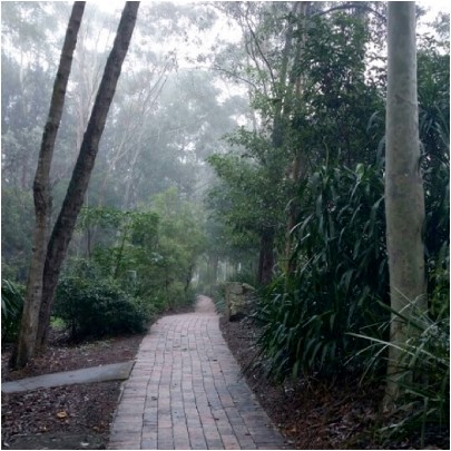 Back in the 1980s IBM built an office complex at 55 Coonara Road, West Pennant Hills. The building design won several architecture awards. The office environment is idyllic. The buildings are surrounded by an extensive tree canopy including Blue Gum High Forest that is now 25 to 30 years old. IBM worked with the National Trust to establish a bush regeneration plan and 40,000 native plants were planted.
IBM sold the land to property developer Mirvac in August 2010. The buildings were renovated in 2011 and IBM is still a tenant but Mirvac has set out to develop the site to take advantage of the site’s location near the Cherrybrook Metro development precinct.
The total site covers about 28 hectares. It is next to Cumberland State Forest. The IBM buildings are on the northern western part of the site. The southern part contains bushland that is at least 70 years old, some having not ever been cleared but may have been logged in the early days as happened in most of Sydney’s original forests. A large part of this area contains critically endangered Blue Gum High Forest or endangered Sydney Turpentine Ironbark Forest. The forest is Powerful Owl habitat plus there is known habitat for the threatened Dural land snail and two vulnerable microbat species. There hasn’t been a full ecological assessment of the whole site.
Mirvac originally proposed to build 1269 dwellings in the area of the old IBM buildings but negotiations with the Hills Shire Council cut this back to 600 dwellings. The whole site including the southern forest is currently zoned as B7, business park. The proposal was considered by council in July. They decided to submit the plan to the Department of Planning for a Gateway Determination of an amendment to the zoning of the site.
Council proposed that the redevelopment area be zoned as R2 medium density, an existing cleared area be RE1 but the remainder, the high quality bushland area, be zoned as R4 high density residential. Importantly, there was going to be no environmental protection for this area containing a significant area of critically endangered forest.
Once it became known all the local community groups formed a coalition called Forest in Danger to oppose the prospect of this magnificent bushland being covered in high rise apartments. In fact the immediate medium density development will also destroy high quality vegetation. There are several other reasons for rejecting the plans that are listed below.
The basic problem is that the reports from Mirvac and council focused on the development site. There was very little information on the rest of the site and therefore no consideration of fundamental issues with the potential loss of biodiversity.
Not only that, the Department of Planning provided a rezoning review briefing report on the site. It noted that A Plan for Growing Sydney does not identify this land for residential purposes and there is no alternative strategy endorsed by council regarding the site’s future use. So, on top of the issues with loss of the forest there is no justification for the rezoning consistent with a strategic plan for additional housing, employment, retail or other business development and transport infrastructure. Traffic on nearby Castle Hill Road is already severely congested. The claims of proximity to Cherrybrook Metro Station are questionable as the walk is more than the desirable criterion of 800 m from the northern part of the site but more like 2 km from the southern part up a steep hill.
The R4 zoning is proposed for the southern area even though no proper assessment has been made of bushfire management, stormwater and flood prone land on top of the loss of biodiversity. Once the zoning is changed the whole forest would be in danger of destruction.
Gateway Determination
Lots of letters of objection have been sent to the Department of Planning and the Hills Council. The Gateway Determination was made on 31 October. The Department of Planning advised council to give proper consideration to appropriate zoning including environmental zones.
One concern with the determination is the suggestion that there could be an area allocated as a forestry zone. The strange aspect of the determination is that the department is allowing council to conduct consultation with the community on an amended plan before the department has reviewed it. Surely the department should consider the new allocation of zoning in light of the overall strategy for north west development so the community has certainty.
Another community forum was held on 18 November in Cherrybrook. Over 250 people attended and heard a detailed description of the flawed process undertaken so far and of what would be lost if the current zoning were to go ahead. The rezoning plan is opposed by several new councillors on council including the mayor and nearby Hornsby Council.
Summary of Arguments against the Proposal
STEP is strongly opposed to any loss of Blue Gum High Forest (critically endangered) and Sydney Turpentine Ironbark Forest (endangered) no matter how small, as these tiny incremental losses will inevitably lead to their extinction in the long term. This applies to the potential loss in the medium density development area as well as the large areas of these forests in the southern forested areas where the R4 zoning is proposed.
Current Proposal for Medium Density Housing (First Part of the Development)
Asset Protection Zones
The proposed asset protection zone around the development area impacts 0.18 ha of Blue Gum High Forest up to 71 years old, and 0.5 ha of Blue Gum High Forest and Sydney Turpentine Ironbark Forest natural remnant bushland. The NSW Rural Fire Service discourages development in bush fire affected areas that would incur significant environmental costs. There are significant environmental constraints here which are not overcome in this proposal.
Impact of Internal Roads
Currently planned internal roads impact Blue Gum High Forest with a loss of 300 m2 proposed.
Powerful Owl
The impact on Powerful Owl residents would be substantial. These owls need not just peaceful nesting trees and roosting habitat but large areas of trees in which to hunt. Substantial numbers of trees 25 to 30 years old would be cleared for this development and hence reduce hunting opportunities and the probability of owl survival.
Fragmentation of the Forests
The Cumberland State Forest and 55 Coonara Avenue currently form an area of over 60 ha of bushland from the ridge, down to gully habitat. The development and asset protection zone reduce the area of trees and forests and the asset protection zone increases the separation of this site from the Cumberland State Forest. This fragmentation reduces the value of this comparatively large area of remaining Sydney Turpentine Ironbark Forest.
Recommendations
We recommend that the application is rejected in its entirety due to its impact on the environment, particularly Blue Gum High Forest, Sydney Turpentine Ironbark Forest and Powerful Owls. Any possible future development must not have any impact on these endangered communities species and Powerful Owls.
The bulk of this land should at the very least be rezoned to E2 for environmental conservation. Ideally the site should be added to the adjacent Cumberland State Forest and conserved in perpetuity.
More Information
For the latest information on the campaign against the development and more detail on issues with the proposal go to www.forestindanger.org.au.
Email or write to:
- Minister for Planning, Anthony Roberts This email address is being protected from spambots. You need JavaScript enabled to view it.
- Member for Bauklham Hills, David Elliot This email address is being protected from spambots. You need JavaScript enabled to view it.
- Director Sydney West Planning This email address is being protected from spambots. You need JavaScript enabled to view it.
- Hill Shire Council Mayor Michelle Byrne This email address is being protected from spambots. You need JavaScript enabled to view it.
Our National Parks Need Protection

Another round of ‘restructuring’ has hit our national parks staff. More managers and rangers with superb skills and experience have to reapply for the jobs they have been performing under extreme pressure from previous cutbacks. It is clear that the Department of Planning and Environment does not value ecological skills any more. Nobody knows what the selection criteria will be for the new positions – tourism experience perhaps?
A group of former NPWS employees has formed a group called Park Watch to monitor the impacts the cuts are having. There is a forum on 30 November at NSW Parliament House to discuss the future of national parks.
Carolyn Pettigrew, one of the members of Park Watch presented a talk on ABC Radio National’s program Ockham’s Razor. Here is a transcript reprinted with permission from Carolyn.
Introduction from Robyn Williams
Conservation. It's a word that sounds a bit like conservative, doesn't it? But the conventional wisdom these days is that environmental matters are green - green in philosophy and probably green in politics. But this didn't used to be the case. When I went to my first meeting of the Australian Conservation Foundation in the early 70s, the president was not Peter Garrett, who would have been about 20 at the time, but Prince Philip. And back then the president of the United States, Richard Nixon, he of tainted memory, was behind some of the most far-reaching environmental initiatives which in 2017 are steadily being dismantled by Donald Trump. So what about our own national parks, where did they come from, and why should we care.
Carolyn Pettigrew
2017 is the 50th anniversary of NSW National Parks and Wildlife Service. Born out of the Land Department's Parks and Reserves division and the NSW Fauna Protection Panel, it was largely the brain child of a Liberal politician, the Hon Tom Lewis.
The service's 50th birthday is a cause for celebration - as some of its achievements are really outstanding. The declaration of the Border Ranges and Blue Mountains National Parks as world heritage regions must be among the highlights, signifying the importance of these areas not only to Australia but the world.
National parks and reserves represent the highest level of protection available to our unique fauna and flora, and are vital to their survival. They are becoming even more important as threatening processes outside the reserve system put pressure on our remaining natural ecosystems. Unfortunately, the ability of our national parks and reserves to protect this natural heritage is being eroded - both within and outside the parks.
The National State of the Environment Report 2016 states that the threatening pressures on biodiversity include land clearing, invasive species, the fragmentation of habitat, changed fire regimes, and climate change.
Most of these exert a high or very high pressure on biodiversity, and are worsening. The cumulative and interacting effects of these pressures amplify the threat to biodiversity in Australia.
Excessive land clearing poses a particular threat.
It certainly surprised me to learn that Australia has a land clearing rate similar to Brazil and Indonesia. Queensland alone has cleared more than one million hectares of woodland in the past 10 years, and New South Wales looks set to follow suit.
In 2013 the NSW Government developed a program called Save our Species (SOS). This program provided the framework for identifying threatened species and what was needed to ensure the survival of threatened species for the next 100 years. It made sense of all the efforts being made by various environmental groups, communities, academic institutions, and the government to halt the loss of species. SOS identifies where the gaps are and ranks the importance of the work needed. Importantly, there is some funding available for groups to carry out the work required.
Backing the SOS plan was legislation designed to protect biodiversity and to halt the loss of habitat on land outside the reserve system. This system of protecting against land clearing wasn’t perfect - but it was crucial to making the SOS plan work.
Unfortunately, it was met with hostile opposition by powerful agri-business and political voices, so instead of modifying the rules the NSW government threw out the legislation.
What we're left with is legislation which is little more than a self-assessment process. If you read what a landholder can clear on their land it is virtually everything.
The loss of habitat that allowed some species to hang on and connect with nearby habitat will be devastating. The remnant koala population in northern NSW is a case in point - trees on private land and roadsides are being cleared at an alarming rate. These koalas seem destined to disappear.
Local citizen scientists, conservation groups like Birdlife Australia and the Australian Wildlife Conservancy and concerned landholders are all doing a magnificent job despite the odds but what are our governments doing?
Which brings me back to national parks and reserves. In NSW about 9% of the total land area is reserves of one kind or another. Not all threatened species depend on national parks and reserves but a hell of a lot most certainly do.
There are huge gaps in what we know about threatened species, their location, habitat requirements and distribution.
Very broadly, threatened species management in national parks and reserves fall into two categories – site-managed species like the Mallee Fowl and landscape managed species such as the threatened Powerful Owl. If I take the latter example, Powerful Owls are top predators. They feed mostly on arboreal mammals – possums of various kinds. That means they need tall forests with lots of hollow trees which also meet the requirements of other threatened species such as the yellow-bellied glider. So the land is managed at the landscape and ecological community level to cover as many species as possible.
Threatened plants and animals are identified in plans of management for a reserve. But there are a multitude of management objectives for each reserve. Making sense of the different priorities, the capital works and the human resource deployment needs professional park managers like graduate rangers and specialists.
You might think we have an army of these people but we don’t. Despite the fact that these are the folk who provide the intellectual grunt in reserve management their numbers are dwindling due to cut after cut. Every time you hear those words efficiency drive or restructure - think job losses. NSW has lost 30% of rangers over the past 10 years and more than 200 field officers, administration, specialist project and support staff.
Rangers and field officers are the men and women who do the hard lifting in our parks and reserves. They carry out fire-fighting, whale rescuing, walking track maintenance, weed control programs - to name just a few of their tasks. Loss of the expert knowledge of graduate rangers and specialists is tragic. These are the people who plan and implement the strategies that conserve representative ecosystems and the habitat of rapidly diminishing native Australian species.
There is even a move in NSW to classify all national parks staff as clerks, lower entry level qualifications and put in place hard progression barriers. Rangers and specialist jobs will no longer specify a degree as an essential job requirement. Of course, graduates could still apply for these jobs, but the career opportunities offered to them will be severely limited due to the hard promotional barriers.
But what has all this got to do with science? Two major impact pressures on threatened species in national parks and reserves are fire management and pest control.
Taking fire management as the example, the media and the public tend to regard the rural fire services as the ‘heroes’ which they definitely are. The problem is fire research and fire mitigation management is at least as important as fire-fighting, but it isn’t as sexy as lots of big red trucks. What is important to remember is that national parks and reserves have been created to conserve representative ecosystems, and fire regimes are biodiversity ‘drivers’ within most of our natural ecosystems. The importance of fire can be best illustrated by the fact that the absence of certain fire frequencies and intensities may be just as detrimental to biodiversity as a regime of fires that are too frequent or too intense.
Fire management, including fire mitigation must be based on good science, not political imperatives. Fire management must also encompass a complete appreciation of the other threatening processes and activities that mitigate against species survival such as habitat loss, soil erosion, water quality and carbon sequestration. That is why national park services throughout the country need a qualified, well-resourced and equipped ranger force to undertake assessment, management and implementation of fire management, soil conservation, weed management, visitor facilities, and development. It requires a holistic view, not simply a view of hazard reduction and asset protection.
We can't expect our parks and reserves to remain in a heathy state if jobs and knowledgeable people keep disappearing.
I believe the rot starts at the top. Increasingly we have ministers for the environment who wouldn’t know a wombat from a woylie. Maybe that’s not important but the same ministers don’t seem to have any regard for the moral responsibility they have as guardians of the natural national estate.
In the recent NSW by-election for the seat of Murray, the Nationals candidate was elected. His primary policy was to log Murray Valley National Park, and if that failed, instigate a land-tenure swap. There simply aren't many areas of river red gum forest left, so a tenure swap is a ridiculous suggestion. If that's not bad enough, the NSW timber industry and their lobbyists are running a campaign, Beyond Tenure, which is a thinly disguised attempt to allow logging in our national parks.
I believe that all of us, citizen scientists, conservation bodies, academics, concerned land holders - need to keep reminding politicians that we value our national parks and reserves. Our national parks and reserves are the genetic gene banks of our precious Australian flora and fauna and we shouldn’t lose them by political ignorance and neglect.
Extraordinary Loss of Trees in Hornsby

Hornsby Council weakened its Tree Preservation Order (TPO) in 2011 so that only tree species indigenous to the area (about 100 species) are protected apart from heritage conservation areas where all trees (as defined in the TPO) are protected. In June 2014 we wrote about a survey of tree cover that revealed that about 2% of the area was lost during 2011-13, about 27% more than the previous 2 years (see STEP Matters, Issue 176, p3). This data was recorded before the 10/50 bushfire clearing regulations came into force plus the tremendous number of new apartment approvals and infrastructure development.
Now the new mayor, Philip Ruddock has expressed shock at the latest data showing that 15,000 trees were cleared in the last year which equates to 60 hectares of canopy. The council has commissioned a report outlining options to strengthen tree protection measures to re-establish Hornsby’s tree canopy.
It is hard to get clear data of the tree cover in Hornsby because about two-thirds of the Shire’s tree cover is in national parks and reserves. Some reports do not make it clear whether they were looking a percentage loss of tree canopy in the total area or just urban areas.
In 2014, 202020 Vision (a collaboration of horticultural companies formed with the objective of making our urban areas 20% greener by 2020) published the Where Are All The Trees? report based on research undertaken by the Institute of Sustainable Futures at UTS Sydney. This was the first time that urban canopy had been benchmarked nationally.
This year, RMIT and Clean Air and Urban Landscapes Hub researchers published a follow-up report called, Where Should All the Trees Go? that compares canopy levels, overlays urban heat and socio-economic data, and provides an overall vulnerability indicator.
This report showed that Hornsby had lost 5% of urban tree canopy over the 5 years to 2016. And the latest report is that over 2016-17 the loss was 3%. At the current rate there will be very little urban tree cover left in 30 years’ time.
Loss in Pittwater (13%) and Warringah (7%) over the 5 years was even worse.
Dr Peter Davies pointed out in his talk at our AGM that there are many factors that will make it harder to increase urban tree cover in the future, the main one being the reduction in housing block sizes. The new block sizes of as little as 250 m2 leave no room for a backyard let alone trees. So the main responsibility for tree canopy will fall on local authorities.
Looking down Harwood Avenue, Mt Ku-ring-gai. Before the change to the TPO in 2011 and the introduction of 10/50 in 2015 it was impossible to see the boundary of Ku-ring-gai Chase National Park. Now the suburban area is stark against the wall of trees in the national park.
Paper Maps are Good Friends

Robin Buchanan reminds us that maps on smart phones have limitations.
‘Just another lost bushwalker’ said the weary voice of the policeman at Hornsby Police Station when I rang to ask why there was a helicopter searching the bush below our house. For those who know the areas of Lane Cove, Berowra and Ku-ring-gai National Parks well it is hard to imagine becoming lost but it happens very regularly and even more so in larger national parks.
Too many people rely on smart phones. These are really useful but they have three disadvantages. They run out of batteries quickly if they are used for navigation for too long, they don’t show landform and they can’t give both a detailed view of where you are at the same time as giving a broad view of the area. Hand held GPS (global positioning system) units are better as they are more rugged; the batteries are only used for the GPS and are easily replaced. They also have designated maps installed but they still suffer the same problem as phones when you zoom in and out.
Paper maps never run out of batteries and you can simultaneously see where you are and where you are going – even if it is several kilometres away. These days I tend to take a phone, GPS and paper map with me at all times as experience has taught me that they all may come in useful. The following examples illustrate how useful maps can be.
We were on a track a friend had walked many years ago but as the sun slid down in the west the track became more and more overgrown and our speed became slower and slower. The GPS told us exactly where we were but the paper map was spread out so we could accurately gauge the distance if we went back, continued on or crossed the valley to a well-established tack. It quickly became clear that forward and backwards would see us out after dark but we should make it if we crossed the valley.
On another occasion a friend decided to walk ahead but missed the turnoff to the cars. No friend when we got there! The map was spread out and his most likely positions determined. The hunt was begun. He was quickly located at one of the points and all ended happily.
I have even given away a map when it was obvious that walkers had no idea of the size of the area in which they were walking: some simple calculations were done; if it has taken x amount of time to walk as far as you have, then to reach Berowra Creek and back is going to take four times as long. That will be after dark. Why not go to a nice lookout instead? Here, have a map.
Groups can gather around a map, make collective decisions, name far mountain ranges and reminisce about walks they have done before or plan the next walk. Good group dynamics.
1:25 000 Maps
The maps that give the largest view of an area are the 1:25 000 series (every distance on the ground is divided by 25 000). These are published by the NSW Government.
Bobbin Head Information Centre in Ku-ring-gai Chase usually have stock of the maps covering local national parks.
Don’t be put off by the name of the maps; they are titled by a main feature on the map. The Hornsby map is not a map of Hornsby, Hornsby is located in the centre of the map and lots of bushland is shown on the map as well. The local national parks are covered by several maps:
- Ku-ring-gai Chase: Hornsby, Cowan, Mona Vale and Broken Bay
- Berowra Valley: Hornsby and Cowan
- Lane Cove: Hornsby and Parramatta River
- Garigal: Hornsby,Parramatta River and Mona Vale
STEP and Friends of Berowra Valley
STEP’s three maps cover the Lane Cove Valley and Middle Harbour (North and South) and are printed at 1:10 000 (ground distances divided by only 10 000). They give a more detailed view of the area but are still broad enough to give you a good view of your surroundings.
The Walking Guide to Berowra Valley National Park published by the Friends of Berowra Valley is printed at a scale of approximately 1:18 000.
WildWalks
WildWalks produces detailed maps and descriptions of particular walks. You can download pdfs but printing them is safest. They are best used in conjunction with maps of the area such as the ones described above.
Great North Walk
The Great North Walk, through Lane Cove Valley and Berowra Valley is covered by The Great North Walk Companion.
Having Trouble Reading Maps?
If you have trouble reading paper maps and would like an introductory course, please let us know! Don’t be ‘just another lost bushwalker’.
New Steps on STEP Track

STEP applied for an Environmental Small Grant from Ku-ring-gai Council last year for further repairs to the STEP Track near the Lane Cove River. Previous repairs were carried out near Kingsford Avenue. The repairs have now been completed so the walk up or down the steep section is now much safer.
Annual Report for the Year to October 2017

The NSW Government forecasts of population growth for metropolitan Sydney over the next 20 years are frightening, at 37% or 1.7 million. Planning systems have been put in place and legislation has been enacted to facilitate development that claim to maintain a ‘liveable’ city but we have serious doubts this can be achieved given the attitude of the current government to the environment. Legislation like the biodiversity offsetting provisions that came into force in August are aimed a facilitating development, not protecting bushland.
STEP and all the community groups that are concerned about the impending loss of native vegetation and suburban trees will need to fight to try to keep Sydney’s unique bushland and wildlife.
This annual report gives a brief summary of our activities over the past year. More details are in the issues of our newsletter, STEP Matters and on our website.
Committee
Several of STEP’s committee members have knowledge of our environment that makes an essential contribution to our work in making submissions and liaising with local councils. They have been doing this voluntary work for many years. There comes a time when dedicated people need to give up these responsibilities.
Andrew Little has decided not to stand for the committee next year. During his period on the committee since 2005 he has provided detailed analysis of local soils, vegetation and bushland restoration issues that has formed the basis of our submissions. He also has detailed knowledge of planning laws and has led and organised our walks program. He will be hard to replace.
Our committee members are being stretched by the volume of developments and changes in legislation. We need more resources to continue our work. If you would like to volunteer or know a potential candidate please let us know. Help with a one-off issue or particular aspects of our work is very welcome.
Publications
The updated version of the Lane Cove Valley map was published late in 2016 and has been well received. The waterproof paper is proving to be much more resilient.
There continues to be steady demand for our maps that are appreciated by those who want to plan a walk by looking at the ‘big picture’ and identify options for different routes.
Sales of books has slowed over recent years in line with the general reduction in interest in larger format books. The Field Guide to the Lane Cove Valley remains the most comprehensive source of information about this beautiful part of Sydney. The Weather Book is useful for all people preparing to venture into the outdoors and simply a great source of information.
Accounts
Our operations broke even over the year so that membership fees and interest income cover our core activities. The use of email to distribute our newsletters has reduced costs significantly.
Total assets reduced due to accounting adjustments writing off the cost of our web system update and donations were made to some other environmental organisations with similar objectives to ours.
We appreciate the pro bono work done by Allan Donald, chartered accountant, who completed the audit of STEP’s financial statements.
Environment Protection Fund
We have maintained the Environment Protection Fund which provides deductible gift recipient status for donations that support STEP’s environmental objectives. We received a total of $349 in donations in the past financial year. The government is still threatening to impose more strict conditions on environment NGOs if they are to maintain entitlement to tax deductibility status of donations.
We have not made any payments out of the Environment Protection Fund for the past two years but we are currently developing a scheme for funding a student research project
Electronic Media
Our website has been working smoothly. Helen Wortham does a sterling job in keeping the website up-to-date and setting up the newsletter on the main page in an attractive and easy to use format so that individual stories can be selected or the whole newsletter can be downloaded.
Trish Lynch and John Burke continue to alert readers to current issues and events through Facebook and Twitter. Trish and John have established links with many like-minded people and organisations. Social media does receive a lot of bad publicity but careful use does facilitate valuable information sharing.
Education
We support the Young Scientist Awards run by the Science Teachers’ Association of NSW with a prize in the environmental sustainability category. The winner of the STEP prize this year investigated the design of nest boxes for sugar gliders.
We also supported the Children’s Threatened Species Art Competition. The primary school children produced some fabulous paintings.
Talks
We organised public talks over the past year on paleoclimatology, environment management in Hornsby, UNESCO World Heritage, the Hawkesbury River and the geology of Sydney Harbour.
Walks
Our walks program was disrupted by wet weather with two walks having to be postponed. Walks were held in the local area and on the Central Coast.
The walks aim to be educational and to encourage new walkers so most walks are not physically challenging. We thank Andrew Little and John Martyn for organising and leading walks this past year. If you have a request for a walk please let us know.
Newsletter
Our newsletter, STEP Matters, is our main means of communicating events, our activities and current issues. We also include other articles with an environmental angle that will be of interest to members. The newsletter is also sent to local councillors and politicians. We welcome alerts from our members of local events and developments and, of course, feedback on articles is always welcome.
Administration Matters
Attendees at the AGM will be asked to approve a major rewrite of our constitution so that it is consistent with the model rules developed by the Department of Fair Trading. We have taken the opportunity to amend our objectives. We continue to focus on conservation of bushland but the defined area of interest is expanded to cover northern Sydney rather than our local area. This reflects the fact that threats are sourced more from broader state issues rather than local government.
We thank Jan Newby for her help in creating the new draft.
Anniversaries
STEP was established in 1978 so 2018 is our 40th anniversary year. We are planning a celebration and publication of a historical report that is being prepared by Graeme Aplin.
It is 10 years since the Blue Gum High Forest Group, a local coalition of groups and individuals, including STEP, was successful in increasing the protection of a significant area of Blue Gum High Forest in St Ives. A number of walks and talks have been organised by FOKE during the year to celebrate this achievement.
Young Scientist Award 2017

STEP continues to sponsor an award for a project about an environmental issue under the Science Teachers’ Association Young Scientist Awards.
It was a difficult decision this year with some innovative and well thought out projects. The winner was Evette Khaziran, year 10, from Redeemer Baptist School, North Parramatta. Her project on the use of nest boxes by sugar gliders was the nearest to STEP's urban bushland focus and philosophy. Not only that, the work was well thought out and innovative with patient field observation and an outcome that could be applied to bushland areas all round metropolitan Sydney and beyond.
Threatened Species Children’s Art Competition

 This year, for the first time, STEP supported a great initiative organised by Forestmedia, an organisation that is aiming to increase community awareness of the plight of our threatened species and help to develop the next generation of environmental leaders.
Long-time STEP member and artist, Yvonne Langshaw, helped judge the winners which were announced on 7 September, Threatened Species Day, at NSW Parliament House.
The competition was very well organised and a great success. The fabulous entries were displayed in Surry Hills, the Botanic Gardens and Canberra.
Jake Ferguson won best written work for the summary below:
When I think of a Corrobboree I don't think of a frog. I think of dancing around on the land. But I guess that’s what a frog does. So I chose this frog because it’s native to our land and it has bright yellow Australian colours of our land. Australia's Southern Tablelands and waterways are very important to the life of this frog. Let’s look after them so the frog can keep dancing.

Lord Howe Island Rodent Eradication to go Ahead

We recently wrote about the exhaustive research, economic analysis and consultation that has been undertaken into a plan to eradicate rats and mice from Lord Howe Island. At last it has been decided to go ahead.
The project will distribute rodenticide (brodifacoum) in cereal-based pellets via helicopter in the uninhabited parts of the island and via hand broadcast and bait stations in the settlement area in winter 2018 (June or July).
Eradicating invasive species from Australian islands has long been recognised as providing immense long-term benefits. It will be a complex operation that requires extensive cooperation but if successful will allow the island’s unique wildlife to flourish and make Lord Howe Island an even more exceptional place to visit.
It isn't Easy being Blue – Cost of Colour in Fairy Wrens

Male superb fairy-wrens change colour every year, from dull brown to bright blue. But being blue may be risky if you are a tiny bird that is easily spotted by predators.
This new study found that male fairy-wrens adjust their risk-taking behaviour after undergoing colour change, becoming more cautious while brightly coloured.
Colour and Risk
For many males, having beautiful colours is important for attracting choosy females. Researchers think attractive colours come with a cost, so that only the highest quality males can afford to display them. This may be helpful to females looking to select the best mate.
One possible cost of bright colours is increased predation risk, as bright animals are easily seen in their natural habitat. This cost can be dramatic (i.e. being eaten) but may more often involve changes in behaviour to mitigate risk, such as spending more time scanning for predators and being more responsive to perceived threats. Such behaviours are costly because they reduce the time available for foraging and are energetically expensive.
A relationship between bright colours, predation risk and cautious behaviour may seem intuitive; however this is difficult to test. This is because different coloured animals may also differ in their age, size, escape tactics and personality, which can influence both their behaviour and actual predation risk.
To address this, we tested whether individuals adjust their response to risk according to changes in their plumage colour.
Fairy-wren Antics
Superb fairy-wrens are small, charismatic songbirds. They live in groups with a dominant male and female and, often, several younger males.
These birds are vulnerable to predators such as kookaburras, butcherbirds, currawongs and goshawks. When a group member spots a predator, it gives an alarm call to warn the others. In response, other group members may race for cover, or ignore the alarm and continue about their business.
Male fairy-wrens change colour by replacing dull brown feathers with bright blue, black and indigo ones prior to breeding, turning brown again after the breeding season is complete. Individuals change colour at different times of the year, ranging from the Australian autumn (March to April) to late spring (October).

Although female fairy-wrens have a stable, social partner, when egg-laying time comes, they briefly leave their territory under the cover of darkness and “visit” the male who became blue earliest in the year. Many of the females in the surrounding area prefer the same male, who may father around 70% of the offspring in the neighbourhood. These attractive males are blue for longest (remaining blue for 10-12 months of the year) and so may face the greatest risk of predation.
Tracking fairy-wrens
We gave fairy-wrens different coloured leg bands, allowing us to follow the same individuals over time.

We compared the behaviour of the same males while they were brown and blue, as well as males that remained brown or blue throughout the study. This meant we could test for the effect of colour on responses to perceived risk while accounting for individual differences and possible seasonal changes in behaviour.
We estimated cautiousness in the birds by testing their response to alarm calls. This involved sneaking up on unsuspecting fairy-wrens in their natural habitat and broadcasting fairy-wren alarm calls from portable speakers.
We used two types of alarms: a low-danger alarm, which warns of a moderate threat, such as a predator that is far away, and a high-danger alarm, which signals an immediate threat.
Costs of being Blue
Responses to the low-danger alarm included fleeing for cover, an intermediate response (such as ducking or looking skywards) and no response, when the alarm was ignored. Fairy-wrens fled immediately after hearing the high-danger alarm, but differed in the time taken to return to the open.
We found that fairy-wrens were more cautious while blue; they fled more often after hearing low-danger alarms and took longer to emerge from hiding after fleeing in response to high-danger alarms. Blue fairy-wrens also spent more time scanning their surroundings and less time foraging compared to brown wrens.
This suggests that fairy-wrens perceive themselves to be at a higher risk of predation while bright blue and adjust their behaviour accordingly.

Blue Decoys?
Intriguingly, fairy-wrens also adjusted their behaviour according to the colour of other wrens in the group. When a blue male was nearby, wrens were less responsive to alarm calls and devoted less time to keeping a look-out.
Perhaps this is because fairy-wrens view blue group members as colourful decoys in the event of an attack. This could occur if predators are biased towards attacking the most conspicuous animal, which reduces the predation risk for surrounding individuals. Brown wrens could also be taking advantage of the greater time blue males spend scanning, allowing them to lower their guard.
Being blue for longest gives males the best chance of attracting females, but they need to be extra careful lest they get eaten before it comes to that.
![]() Coauthors on this research are Annalise Naimo, Niki Teunissen, Robert Magrath and Kaspar Delhey.
Coauthors on this research are Annalise Naimo, Niki Teunissen, Robert Magrath and Kaspar Delhey.
Alexandra McQueen, PhD Candidate in Behavioural Ecology, Monash University and Anne Peters, Associate Professor, Monash University
This article was originally published on The Conversation. Read the original article.
Finkel Review on the Electricity Market – What Happens Now?

The Chief Scientist, Dr Alan Finkel, was asked by the Council of Australian Governments (COAG) to undertake an independent review of the national electricity market (NEM) that:
- delivers on Australia’s emissions reduction commitments
- provides affordable electricity
- ensures a high level of security and reliability
This was complicated task that needed to take into account:
- the closure of ageing coal-fired power stations
- escalating extreme weather events (like heatwaves, bushfires and storms) driven by climate change that test the resilience of the system
- increasing gas prices
- rapidly declining costs of wind, solar and battery storage
It also had to be politically palatable for the federal and state governments.
The energy users, the general public and industry just want long-term policy certainty.
The major points made by the review and the Climate Council’s view are summarised below.
1. Emission Reductions
The minimum target for reducing emissions in the electricity sector should be a 28% emissions reduction below 2005 levels by 2030. While it places responsibility for more aspirational targets to 2030 and beyond with government(s), the review cautions higher targets could have ‘larger consequences for energy security’ and ‘implications should be re-examined’.
This target is consistent with the commitment made by Australia at the Paris Climate Change conference but the electricity sector needs to bear a greater share of the reduction. It is easier to reduce emissions in the electricity sector as many of the required technologies already exist and reductions in other sectors like transport and land use are harder to achieve. The Climate Change Authority, the government appointed advisory body, suggested that electricity emissions should reduce by two-thirds by 2030 and be zero by 2050.
2. Clean Energy Target
The Finkel Review proposes introducing a Clean Energy Target, which would effectively replace the current Renewable Energy Target from 2020. Gas and coal (with carbon capture and storage) would qualify under the Clean Energy Target, as well as renewable energy. The Clean Energy Target would set a certain target amount of new ‘clean’ electricity (expressed as GWh or % of electricity) based on the required emissions reductions for the electricity sector. The Finkel Review leaves the target baseline and emissions trajectory to 2030 and beyond for politicians to decide.
Technologies with lower emissions, like renewables, would receive higher benefits than those with higher emissions, like gas and coal (which would still be required to be below a set emissions intensity level to receive any benefit). New coal stations that do not meet the target can still be built without penalty, increasing the emissions reduction burden from ‘clean’ electricity.
The Clean Energy Council website explains this mechanism in more detail. Modelling undertaken for the Finkel Review (based on 28% emissions reduction for the electricity sector) indicates the Clean Energy Target mechanism (and an emissions intensity scheme) would result in lower costs to households and businesses compared with no action at all (business as usual). The modelling shows renewable power continuing to grow, up to 42% of electricity supply by 2030 (58% still comes from fossil fuels by then, with no further brown coal closures), in contrast to business as usual of 35% renewable electricity.
Power generated by renewable energy in 2030 under the proposed Clean Energy Target – at 42% – is far too low. Under the Clean Energy Target, electricity supply from large scale renewable energy would only increase 9% from 2020–30 (about the same increase as has occurred in the past ten years, a decade marked by significant climate and energy policy uncertainty).
3. Renewable Energy Reliability
The Finkel Review recommends a new requirement on new wind and solar power plants to provide a certain level of ‘dispatchable’ capacity (this was called a Generator Reliability Obligation). Dispatchable capacity is electricity that is available on call, as and when needed. New wind and solar would be required to provide a certain amount of battery storage or gas generation as determined by energy market bodies so that power is available with certainty, for example, when the wind isn’t blowing and other sources cannot provide sufficient power.
There was no equivalent requirement placed on new, or existing ageing gas or coal generation, despite the failure rate of ageing power stations increasing. For instance, in early February 2017, a severe heatwave across much of Australia’s south east and interior caused supply issues for the South Australian and NSW energy systems at a time of peak demand. In NSW around 3000 MW of coal and gas power capacity was not available when needed in the heatwave. High power users in industry were required to scale back production at great cost.
4. Future of Coal
The Finkel Review recommendations focus on incentives to encourage new lower emissions power plants to be built, rather than phasing out or penalising polluting coal and gas plants. So the approach is intended to bring on new renewables without incentivising the phase out of existing polluting coal generators. Coal generation would continue to provide over 50% of Australia’s electricity by 2030 and 24% by 2050.
Coal should be phased out much more quickly. Australia’s coal-fired power stations are old, and polluting by world standards. The Finkel Review acknowledges that by 2035:
… approximately 68% of the current coal generating plants will have reached 50 years of age.
Its modelling shows most still operating at 2030 and some even by 2050. The review even considers it a ‘benefit’ for these old, polluting coal plants to continue operating.
The key recommendation for coal-fired power is a new requirement for power plants to provide three years notice before closing. A schedule for the closure of aged plants should have been established years ago.
5. Future of Gas
The Finkel Review provides for a continuing role for gas power generation despites the issues with methane emissions and local environmental impacts of coal seam gas extraction. It acknowledges gas prices (and, as a result gas power prices) will continue to rise in future due to the demands of liquefied natural gas exports from Queensland, and the increasing price of producing gas from unconventional gas fields.
At current gas market conditions, it observes that battery storage may be more cost effective than gas in providing security and reliability in the near future. However, the Finkel Review paradoxically urges government and industry to prioritise gas exploration and development.
See STEP Matters Issue 190 for more details on the issues with gas powered electricity.
Government Response
The Turnbull government has supported all the recommendations except the Clean Energy Target. They can’t get away from the vested interests of the coal industry. There are even rumours that they would consider providing financial support for a new ‘clean’ coal-fired power plant.
Coal-fired power is on the way out, globally, and in Australia. Clean coal is very expensive, if not technically impossible. But using public funds to prop-up this 19th century technology would lock in climate-destroying pollution and higher power prices for decades to come.
The Turnbull government is out of step with state/territory and local governments. State and territory governments are already on track to deliver the Clean Energy Target on their own:
- Victoria, Queensland, Northern Territory and South Australia are set to generate 40–50% renewable energy by 2030
- Tasmania is already running off 90% renewable energy
- ACT has contracted enough renewable energy to meet all its electricity needs by 2020
The states are setting strong targets that will help Australia reach net zero emissions by (and ideally before) 2050 in order to protect Australians from worsening climate impacts.
South Australia is about to get a 150 MW solar thermal power plant that will meet 5% of the state’s power needs. The 150 MW plant near Port Augusta is expected to be operational by 2020 and will power all the South Australian government's electricity needs. The plant uses the sun as a source of heat that is reflected by mirrors onto a tower containing molten salt that is used to create steam that drives a turbine. It is expected that more of these plants will be built.
Several local governments including Ku-ring-gai, Willoughby and North Sydney, have signed up with the City Powers Partnership set up by the Climate Council. Local councils who join the partnership pledge to take five key actions across renewable energy, efficiency, transport and working together. The partnership acts as a support network for sharing expert information and establishing joint projects.
The information in this article is sourced from the Climate Council’s commentary called Unpacking the Finkel Review.
Protect Sydney’s Green Spaces

One of the major concerns about the NSW government’s biodiversity laws is the fundamental flaws in the Biodiversity Offsets Scheme, which will lead to the widespread clearing of remnant bushland in the Greater Sydney area, in return for developers' cash payments – see STEP Matters Issue 191. The application of these payments is unlikely to make up for the biodiversity that is lost. Several groups are so concerned that they have written a joint open letter to the premier. It is not only environment groups involved. Others are the Heart Foundation, the Institute of Landscape Architects and the National Trust.
The letter (see below) calls for action from the government to make the rhetoric a reality that the legislation will improve biodiversity within Sydney. Members of the general public are invited to sign the letter.
Dear Premier
With Sydney’s population projected to grow to 6.4 million by 2036 and the worsening climate change-related urban heat island effect, we write to urge you to ensure that adequate levels of green space are provided to all Sydney-siders and Sydney’s unique bushland and wildlife is protected.
Sydney-siders highly value access to a range of formal and informal green spaces – trees, bushland, parks and sporting fields. This is borne out in previous public surveys and the strong community reaction whenever public green space is sold-off or alienated for development.
Extensive research, both in Australia and overseas, clearly shows that the environmental, social, spiritual and economic benefits of green spaces are irrefutable. Green spaces cool our city, reduce energy costs, increase property values, promote healthy lifestyles, improve air and water quality, reduce net carbon emissions, prevent stormwater runoff and provide important wildlife habitat.
Sydney's green spaces also play a key role in the health of Sydney's iconic blue spaces. For example, the revitalisation and resilience of Greater Sydney's six major river systems – Hacking, Georges, Cooks, Parramatta, Nepean and Hawkesbury, as well as Botany Bay and Sydney Harbour depends on the health and connectivity of the surrounding vegetation.
Despite these benefits, current NSW government policy and legislation is failing to protect Sydney’s green spaces as these are actively being depleted by clearing and alienation for grey urban and industrial infrastructure development. The Total Environment Centre’s SOS Green Spaces map highlights over 70 green spaces currently at risk of destruction. This includes peri-urban areas undergoing rapid development and the impacts of major transport infrastructure projects such as the South East Light Rail and WestConnex. This deteriorating situation must be addressed as a matter of urgency.
A Plan for Growing Sydney Direction 3.2 aims 'to create a network of interlinked, multipurpose open and green spaces across Sydney' also known as the Green Grid. This concept is also supported by the work of the Greater Sydney Commission. However, specific actions, policies, legislative changes and funding are required to shift this concept from rhetoric to reality.
As key stakeholders representing a wide range of interests and expertise about urban green spaces, we urge you to:
- Assign responsibility for planning, implementing and monitoring Sydney’s green spaces to an independent body with the mandate, skills, funding and resources to achieve a comprehensive network of formal and informal green spaces designed to maximise benefits to Sydney-siders and protect Sydney's unique bushland and wildlife in the long-term.
- Prevent the clearing of bushland in the Greater Sydney area unless strict like-for-like offsets can be located and protected in perpetuity within the close vicinity of the bushland being cleared (note: under the government’s current draft Biodiversity Conservation Regulation 2017, the proposed Biodiversity Offsets Scheme will lead to widespread clearing of Sydney’s remnant bushland, including threatened species habitat, particularly in Western Sydney).
- Prevent the alienation of community and Crown land, as well as removal of the tree canopy, from Sydney’s green space network.
Sydney's green spaces are a vital component of its liveability and resilience as a city. Your positive action in protecting and enhancing our green spaces would strengthen your leadership in Australia’s much-loved and admired iconic first city, for current and future generations.
We, the sixteen signatories to this open letter look forward to an opportunity to discuss this important issue further with you.
Tax Deductibility Status of Donations to Environment Groups Under Threat

STEP’s public fund, the Environment Protection Fund, is registered as a Deductible Gift Recipient (DGR) via the Register of Environmental Organisations administered by the Department of Environment and Heritage. This means that donations to the fund can be claimed as a tax deduction.
We have received the annual return form. This form used to be a simple exercise especially for a small organisations like STEP. However this time there are more questions. The government wants to know the breakup of the application of donations in categories of on-ground environmental remediation (no definition provided), research, education, advocacy, legal, overseas, administration and staff. Is this question anticipating a change in the eligibility requirements for DGR status of donations?
In 2016 the Senate Standing Committee on the Environment conducted an enquiry on this issue. The committee’s report concluded that the purpose of granting DGR status should be to support practical environmental work in the community but then took a very narrow interpretation of the meaning of ‘practical’ and recommended that:
annual expenditure on environmental work be no less than 25% of the organisation’s annual expenditure from its public fund.
Treasury has released a Discussion Paper on this issue and the general administration processes for charities. Currently there is overlap and some confusion between reporting and responsibilities under the Charities and Not-for-profits Commission and the Register of Environmental Organisations. Resolving these issues is welcome but they are also proposing that eligibility should be based on the amount of remediation work carried out.
Why single out the environment organisations for what is basically a financial penalty compared with other charities and lobby groups?
The Discussion Paper states that:
DGR tax arrangements are intended to encourage philanthropy and provide support for the not-for-profit (NFP) sector. Along with other tax concessions to the NFP sector, DGR status encourages the delivery of goods and services that are of public benefit.
It asks for ‘stakeholder views’ on the recommendations of the parliamentary committee, and also whether the government should go even further:
Views are sought on requiring environmental organisations to commit no less than 25% of their annual expenditure from their public fund to environmental remediation, and whether a higher limit, such as 50%, should be considered?
We ask the question, is the revenue forgone in providing tax deductions to environment groups a cost or a benefit? It is more cost effective to prevent damage to the environment in the first place rather than clean up the mess afterwards.
Activities like research, education and monitoring are vital for the prevention of damage. Take as an example the recent ABC program on Four Corners of illegal dumping of construction waste next to the Hunter River discovered by the Community Environment Network on the Central Coast. They were doing the job for the Environment Protection Authority. How much would the clean-up cost if dumping continued unabated? This monitoring would not count as remediation.
Donations and their tax deductibility are especially valuable for organisations like the Environmental Defenders Offices that provide a vital means for the general public to receive advice of their rights when threatened by developments.
Often it is the people living near the development site or mine who are aware of the potential damage not the government bodies. Take the coal seam gas exploration operations as an example, local farmers had no way of obtaining the scientific analysis to be able to object to miners entering their land. Ultimately when the full picture of potential groundwater pollution became clearer the NSW government had to take steps to limit the powers of miners to explore.
Business lobby groups like the NSW Minerals Council are actively supporting the limitation on deductibility status on the grounds that groups like Lock the Gate are simply activists ‘destroying the economy’.
If the proposal goes ahead it will demonstrate that the financial clout and expert lobbying teams of business interests are more important than the views and wellbeing of individual citizens who are concerned about the environment or are adversely affected by a development.
Submissions are now closed but STEP found out about the paper in time to make a submission. It is not too late to send a protest to your local member of federal parliament.
How Should the Flood Risk from the Hawkesbury Nepean be Managed?

The NSW government thinks that raising the spillway wall of Warragamba Dam by 14 m will significantly reduce the risk of floods inundating homes in western Sydney. But experts have questioned whether the raising will achieve worthwhile benefits and whether the ecological damage can be acceptable. They argue the water levels in the dam storage should be better managed instead.
Brief History of Sydney’s Water Supply
The first water supply dams built to supply Sydney were the Upper Nepean dams (such as Avon and Cataract Dams) that still provide 20-40% of our supply. When this supply became inadequate the next step was the construction of Warragamba Dam that commenced in 1948 and was completed in 1960. The resulting storage in Lake Burragorang is one of the largest reservoirs for urban water supply in the world.
Following 1988 and 1989 high rainfall years, the NSW government re-evaluated the potential rainfall and flood risks and raised the dam wall by 5 m and constructed an auxiliary spillway on the east bank of the dam.
Back in February 2007 the Warragamba Dam water supply fell to its lowest recorded level of 32.5% after the prolonged drought from 1998. In response conservation measures and water usage restrictions were introduced. The desalination plant was built at Kurnell but this has hardly been used as we have had a period of above average rainfall ever since. Now the concern is flood risk. In 2012 and 2015 water had to be released to prevent a mass overflow. Currently the level is around 91%.
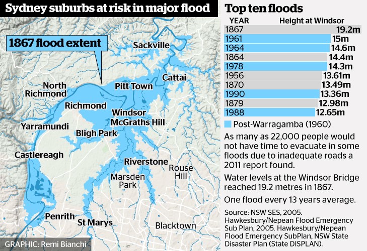 The benchmark for flood risk often used is the worst recorded flood that occurred in 1867 when the water height at Windsor Bridge was 19.2 m. This figure (from Sydney Morning Herald) provides data of past major floods and the flood extent in 1867.
According to the State Emergency Service, the estimated rainfall in 1867 in the lead up to the flood was 770 mm over three days averaged over the entire Nepean River catchment. The flood experience would be different now because several dams have been built in the Nepean catchment.
Government Proposals for Flood Mitigation
The high rainfall experienced in 2013 led to the need to release water causing minor flooding. The NSW government initiated another Hawkesbury Nepean Flood Management Review.
The review concluded that there is no simple solution or single infrastructure option that can address all of the flood risk in the Hawkesbury Nepean Valley floodplain. The risk will continue to increase with population growth. Evacuation is the only mitigation measure that can guarantee to reduce risk to life. According to the State Emergency Service a flood at the 1867 level would now lead to the evacuation of 90,000 people, damage to 12,000 homes and a cost of $5 billion.
As Prof Paul Boon explained during his STEP talk on 11 July on the Hawkesbury River, the topography of the river valley creates several challenges in understanding and managing flood risk.
The Hawkesbury has two main sources, the huge catchment of rivers that flow into Warragamba Dam that has its own flood plain from Emu Plains to Castlereagh. Then the Hawkesbury starts at Yarramundi when water sourced from the Grose Valley catchment in the Blue Mountains joins the Nepean. There is a flood plain around Richmond and Windsor through to Cattai but then more rivers join in and the valley narrows again with steep sandstone gorges and many twists and turns. This means that floods can bank up and spread out over broad areas of western Sydney.
Recommendations of the Review
Some points from the first review report are:
- Due to time constraints the review only assessed the flood mitigation potential of raising of the Warragamba Dam wall crest by 15 and 23 m. Pre-feasibility construction costs and reduction of flood levels have been calculated. However, economic, environmental and social costs and benefits have not been included at this stage. Detailed cost benefit analysis will be conducted for the options for the raising of Warragamba Dam in Stage 2 of the review.
- The review also assessed the potential for changing the operation of Warragamba Dam at its current configuration to provide for flood mitigation. Options examined different ways to create airspace to capture a portion of incoming floodwaters, by reducing the full supply level of the dam, ‘pre-releasing’ water if major flood inflow are expected based on forecast rainfall, or ‘surcharging’ the dam level during floods using the dam’s gates.
- The review concluded that only minor floods, below levels where significant damages occur, could be mitigated using the current dam unless its role as the main water supply to Sydney was compromised. It was also concluded that ‘pre-releasing’ of water from the dam prior to a flood was limited due to the inaccuracies in rainfall forecasts beyond three days, and the potential to increase or prolong downstream flooding.
- Reducing the full supply level of Warragamba Dam provides only a reduction in minor flooding and needs to be assessed against the impacts on Sydney’s water supply. The review considered lowering the full storage level by 2, 5 and 12 m, and concluded that the 2 m lowering had minimal flood mitigation benefits, and the
12 m lowering would have significant impacts on Sydney’s water supply. - Stage 2 of the review will further analyse surcharging the gates and reducing the full supply level for the mitigation of smaller floods, including the operational risks and the impact on Sydney’s water supply.
Even though Stage 2 of the review has not been completed, WaterNSW has been preparing environmental impact statements based on a proposal to raise the dam wall by 14 m and made a referral under the Federal Environment Protection and Biodiversity Conservation Act on specific matters of national environmental significance.
The intended operation after the spillway wall is raised is for water to be held back during a heavy rainfall event and then released slowly in the following weeks. This will provide additional time for evacuation and reduce the downstream flood peak. The stated intention is not to increase the current overall water storage level.
Environmental Impacts
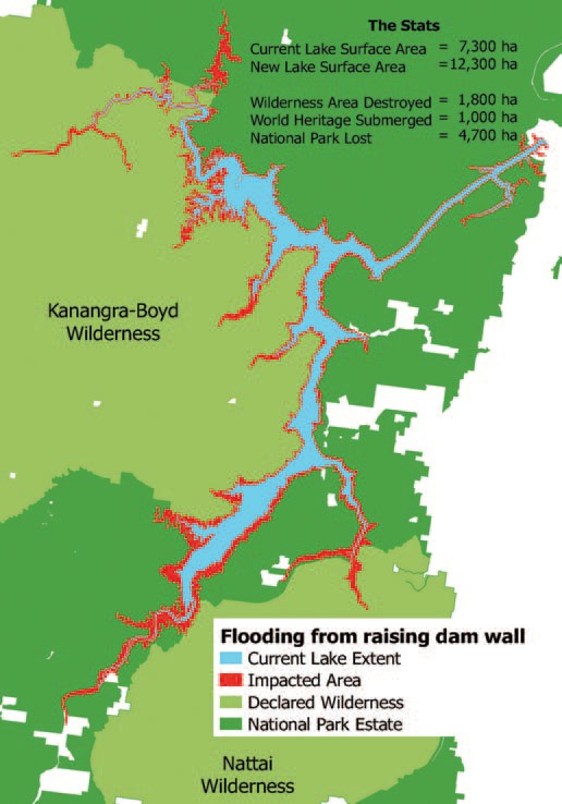 The Colong Foundation for Wilderness has expressed serious concerns about the impact of the current proposals. The fundamental points made in their Colong Bulletin (July 2017) are:
- Raising the dam level does not deal with the flood waters coming from the major rivers further downstream such as the Grose, Macdonald and Colo.
- The extra water storage is intended to be temporary but the vegetation around Lake Burragorang and its tributaries that will, nevertheless, be flooded for several weeks will die leaving ugly scaring of the banks. The upstream flooding will impact the Kedumba and Colong River valleys that are part of the World Heritage listed wilderness areas. A further 1800 hectares could be flooded and another 33 km of rivers inundated.
- The backed up water in the Kedumba River will be visible from Echo Point, the iconic lookout in the Blue Mountains at Katoomba. The figure illustrates the projected increase in areas affected by inundation.
- Even flooding from a 1 in 50 year flood will extend 5 km into the Kedumba Valley and cause the death of 40% of the critically endangered Camden White Gum Forest. This species is listed as vulnerable under the Threatened Species Conservation Act. The Department of the Environment includes the forest in the Kedumba Valley as part of the Save Our Species biodiversity restoration program with an objective ‘to secure the species in the wild for 100 years and maintain its conservation status under the TSC Act’. Methinks WaterNSW should talk to the Department of the Environment.
- Aboriginal cultural heritage will be destroyed.
- Classic bushwalking areas will be lost, historic campsites drowned and access restricted. Bushwalkers are drawn to the pristine Kowmung River, a wild river that has inspired generations of walkers.
Can the Water Storage Level be Managed Instead?
Assoc Prof Stuart Khan, an expert in water engineering, disagrees with the need to raise the dam level. Management of the water level by controlled releases is a safer option so that the dam is never full. The desalination plant that can supply 15% of Sydney’s water needs, could be put to use when the need arises by way of earlier releases. Basically he disagrees with the review’s conclusions.
This is a fascinating risk management problem. Should we:
- reduce the water level if a period of heavy rainfall is projected and thereby reduce the water supply capacity with the backup of the desalination plant; or
- increase the dam wall at great expense and environmental damage that would threaten the tourism industry but still not eliminate the flood risk
Whatever option is taken flood risk cannot be eliminated. However the government is still going ahead with allowing massive population increase in the flood plains of the Hawkesbury Nepean system. As population grows the warning time needed to organise evacuation will increase.
Given the improvement in longer term weather forecasting. The government must explore options for smarter use of risk management techniques to adjust the storage levels. Raising the dam wall ignores this potential and could be a waste of $700 million.
Also future governments could easily be tempted to use the raised dam wall to increase water storage permanently to provide water supply for Sydney’s projected massive increase in population.
Other Serious Water Management Issues
As reported in the Sydney Morning Herald on 21 August, coal mining is impacting on the Sydney water supply catchments but the government is not carrying out adequate monitoring.
The 2016 Audit of the Sydney Drinking Water Catchment was tabled in parliament on the quiet. The National Parks Association discovered the report. It revealed that groundwater losses from longwall mining under the catchments in the Woronora areas has not been quantified. This is despite mining company reports have indicated that about 25 to 40 million litres a day have been entering the mines.
The 2013 audit report revealed that research was underway into the connectivity of surface and groundwater but no results have been revealed in the 2016 audit. This is not good enough given that these mining companies are still applying to expand their mining operations under the catchment.
There are also problems with coal mines leaking toxic chemicals into catchment rivers. Examples are the Springvale mine that has been pumping untreated waste into the Coxs River and the closed Berrima mine that has been leaking pollutants into the Wingecarribee River.
Fifty Years of the NPWS but is Anyone Celebrating?

In the early days of settlement in NSW development decision-making took little heed of its impact on the environment, the loss of flora and fauna and associated ecological communities.
In the 1970s, as human impact on our natural environment became more pervasive, a greater understanding developed of what was being lost and appreciation grew of our unique flora and fauna. Changes in attitudes led to the passing of legislation such as the Threatened Species Act, planning laws that include assessment of environmental impacts and the creation of the National Parks and Wildlife Service (NPWS).
The NPWS was established in 1967, 50 years ago, when the Fauna Protection Panel that was constituted under the Fauna Protection Act 1948 amalgamated with the Parks and Reserves Branch of the Department of Lands. The purpose of the act was to provide for the protection and preservation of fauna, while permitting the destruction and control of those species which were harmful to primary producers. The act applied to all fauna whether native or introduced.
The national park estate has been steadily increased over the years so that now 872 reserves and parks are under NPWS management. However the declaration of new national park areas has been reduced to a trickle in recent years. The area of the state represented is now about 9% of the total land area.
NSW has fallen well behind in achieving its international commitments to biodiversity protection. As a signatory to the International Convention on Biological Diversity, NSW has voluntarily committed to protect, by 2020, at least 17% of terrestrial and inland water, and 10% of coastal and marine areas. There is a lot of catching up to do.
It is hard to see these international commitments being met when the current government attitude is to treat the NPWS as a poor relation. There has been a steady reduction in funding since the Liberal National government came into power in 2011.
Staff numbers have been cut through regular redundancy programs so that vital long-term experience has been lost in areas like remote area bushfire fighting and vegetation restoration.
Staff have been subject to repeated structuring, the latest being a reduction in the number of regional managers from 14 to 8. Regional managers will now have impossibly large areas to manage.
Funding has been diverted to eye catching new projects rather than repairing degraded facilities and heritage sites.
In a frank internal memo in June last year, then deputy chief executive Michael Wright acknowledged that NPWS staff were facing:
… ongoing budgetary pressures associated with increasing costs and salaries, and decreasing expense allocations across future years … We need to be proactive in identifying and implementing opportunities for savings to be made and revenue to be increased, to ensure we can continue to implement our core conservation, emergency response and visitor services for the people of NSW.
The savings are being imposed despite the NSW being in a bumper financial position following asset sales and booming stamp duty income. And yet the Office of Environment and Heritage website describes national parks as a ‘bedrock of nature tourism’.
No wonder the government is making the 50 years anniversary a low key event! The situation is an embarrassment to a state with such magnificent natural areas that are a major drawcard for local and international visitors. The newspapers have been full of complaints about the deteriorating visitor facilities. The money is being spent on high profile development such as the mountain bike tracks in Garigal National Park and sports stadiums.
The current executive of the Office of Environment and Heritage has refused a proposal to update a 2006, 40th anniversary document, made available through a freedom of information request, to mark the 50th anniversary. The document, NSW NPWS Commemorative History 1967–2007 was withheld, effectively suppressed, by the then Department of Environment and Climate Change executives when the authors refused to make requested changes. It has remained in draft form under copyright ever since.
The treatment of national parks is consistent with other Baird/Berejiklian government decisions to reduce land clearing restrictions and threatened species protection and facilitate development with reduced standards for biodiversity offsetting. It seems care for the environment is not consistent with the politicians’ mantra of growth at any cost.
Royal National Park Threat
The latest insult is the suggestion by the powerful Roads and Maritime that 60 hectares of the Royal be acquired for an extension to the F6 freeway from Loftus to Waterfall.
The Royal is Australia’s first national park that was reserved for protection. It was formally proclaimed on 26 April 1879.
To make matters worse there has been a push to have the Royal National Park inscribed on the World Heritage list. This process has widespread support from conservationists and the local communities. In July a technical obstacle to including the Royal on the World Heritage List was removed by UNESCO’s World Heritage Committee when they added a listing criterion of ‘an area of importance in world protected area history’ (Mosley 2012). If the land excision for the F6 goes ahead there would be little chance that the listing could be accepted.
Mosley, JG (2012) The First National Park: A Natural for World Heritage, Sutherland Shire Environment Centre
Invitation to Participate in the Recent Climate-driven Ecological Change in Australia Project
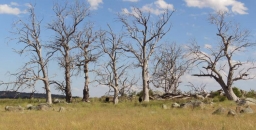
Over the past century, average land surface temperatures have risen by almost 1°C across the Australian continent. Models suggest this may have already had significant impacts on Australia’s ecosystems and biodiversity, but these impacts have not been systematically investigated.
CSIRO Land and Water and the Department of the Environment and Energy are undertaking an exciting project to collect observations and anecdotes that will help to build a national picture of the kinds of ecological changes that have been occurring across the country over the past 10 to 20 years or more, and where changes may not have been occurring. We are looking for people with strong links to Australian environments (e.g. farmers, natural resource managers, ecologists, naturalists, rural scientists) to share their perceptions of recent ecological change (or lack of it) in an area they know well, and how this might link with climate or other change.
To participate, you would need to be able to select a natural area (e.g. your local region or farm, a nature reserve, urban bushland) that you have been familiar with for at least the last 10 years. Note that we are interested both in areas where change has been observed and where change has not been observed.
The survey will take about 30 min. Click here for additional information about the project.
Development Proposal Adjoining Cumberland State Forest

Please consider sending a submission opposing Mirvac's rezoning and development proposal for land adjoining Cumberland State Forest in West Pennant Hills to:
- Minister for the Environment, Gabrielle Upton This email address is being protected from spambots. You need JavaScript enabled to view it.
- Shadow Minister for Environment, Penny Sharpe This email address is being protected from spambots. You need JavaScript enabled to view it.
- Minister for Planning This email address is being protected from spambots. You need JavaScript enabled to view it.
- Hills Shire Council This email address is being protected from spambots. You need JavaScript enabled to view it.
- Member for Baulkham Hills This email address is being protected from spambots. You need JavaScript enabled to view it.
Background
The proposal is to rezone the majority of the 26 hectare site of heavily forested land to R4, high density residential. About 12 hectares on the southern side is of high ecological value containing critically endangered Blue Gum High Forest or endangered Sydney Turpentine Ironbark Forest. The rest of the site contains many mature trees believed to be over 30 years old.
The initial development plan is to allow for 400 apartments and 200 medium density houses in the northern part of the site with associated tree removal for bushfire protection. The proposed rezoning would allow eventual construction of apartment dwellings plus a recreational area on the entire site with no protective environmental zoning. This is a crucial example of the potential destruction under the NSW government’s new Biodiversity Offset laws.
The government is currently considering whether to give this rezoning proposal its in principle blessing under the Pre-Gateway review process and it is expected to be before the Hills Council before the end of the year.
Draft Submission Points
Thank you for the opportunity to make a submission on the proposed amendment to the Hills Local Environment Plan 2012 to facilitate medium to high density development at 55 Coonara Avenue, West Pennant Hills. This proposal is strongly opposed for the reasons outlined below.
- The proposed rezoning to R4 (high density residential) would apply to over 23 hectares that contains critically endangered Blue Gum High Forest and endangered Sydney Turpentine Ironbark Forest but no protective environmental zoning has been proposed. Any high density development would also destroy Powerful Owl habitats. This owl species is listed as a vulnerable species in NSW. An ecological assessment of the site discovered nesting trees and roosting habitats on, and adjacent to the proposed 28 hectare development.
- The initial development plan is to allow for 400 apartments and 200 medium density houses on the northern part of the site. Not only is the proposed development environmentally damaging – it also lacks appropriate infrastructure and amenities, with the nearest public transport link more than a kilometre away up a steep hill. Apart from losing treasured local bushland, neighbouring residents would also have to contend with additional traffic gridlock on local roads, especially Castle Hill Road, as a result of the increased local population.
- The bulk of this land should be rezoned as E2 for environmental conservation with strong protections for mature trees on any part of the site rezoned residential. We want this beautiful rare forest to be protected, not bulldozed for high-density apartments.
Special Resolution to Change STEP's Constitution

A special resolution will be moved at our AGM to modify our constitution.
In accordance with the constitution, official notice is hereby given of the proposed resolution.
Click here for a copy of the proposed constitution and a brief summary of the main changes.
Summary of Main Changes
The Department of Fair Trading has prepared a model constitution and we have used this to update our constitution. The main changes are that we have:
- updated the objects
- defined family and life membership as up to 2 members living at the same address
- stated that 4 constitute a quorum
- provided for a number of management processes and procedures to be carried out electronically, i.e. application for membership, register of members, signing of minutes, use of technology at committee members, making decision, electronic ballots, calling of special general meetings, use of technology at general meetings
If you have any questions, please send them to This email address is being protected from spambots. You need JavaScript enabled to view it. or call Helen on 9144 2703.
The Decoupling Delusion: Rethinking Growth and Sustainability

Our economy and society ultimately depend on natural resources: land, water, material (such as metals) and energy. But some scientists have recognised that there are hard limits to the amount of these resources we can use. It is our consumption of these resources that is behind environmental problems such as extinction, pollution and climate change.
Even supposedly 'green' technologies such as renewable energy require materials, land and solar exposure, and cannot grow indefinitely on this (or any) planet.
Most economic policy around the world is driven by the goal of maximising economic growth (or increase in gross domestic product – GDP). Economic growth usually means using more resources. So if we can’t keep using more and more resources, what does this mean for growth?
Most conventional economists and policymakers now endorse the idea that growth can be 'decoupled' from environmental impacts – that the economy can grow, without using more resources and exacerbating environmental problems.
Even the then US president, Barack Obama, in a recent piece in Science argued that the US economy could continue growing without increasing carbon emissions thanks to the rollout of renewable energy.
But there are many problems with this idea. In a recent conference of the Australia-New Zealand Society for Ecological Economics (ANZSEE), we looked at why decoupling may be a delusion.
The Decoupling Delusion
Given that there are hard limits to the amount of resources we can use, genuine decoupling would be the only thing that could allow GDP to grow indefinitely.
Drawing on evidence from the 600-page Economic Report to the President, Obama referred to trends during the course of his presidency showing that the economy grew by more than 10% despite a 9.5% fall in carbon dioxide emissions from the energy sector. In his words:
…this 'decoupling' of energy sector emissions and economic growth should put to rest the argument that combating climate change requires accepting lower growth or a lower standard of living.
Others have pointed out similar trends, including the International Energy Agency which last year – albeit on the basis of just two years of data – argued that global carbon emissions have decoupled from economic growth.
But we would argue that what people are observing (and labelling) as decoupling is only partly due to genuine efficiency gains. The rest is a combination of three illusory effects: substitution, financialisation and cost-shifting.
Substituting the Problem
Here’s an example of substitution of energy resources. In the past, the world evidently decoupled GDP growth from buildup of horse manure in city streets, by substituting other forms of transport for horses. We’ve also decoupled our economy from whale oil, by substituting it with fossil fuels. And we can substitute fossil fuels with renewable energy.
These changes result in 'partial' decoupling – that is, decoupling from specific environmental impacts (manure, whales, carbon emissions). But substituting carbon-intensive energy with cleaner, or even carbon-neutral, energy does not free our economies of their dependence on finite resources.
Let’s get something straight: Obama’s efforts to support clean energy are commendable. We can – and must – envisage a future powered by 100% renewable energy, which may help break the link between economic activity and climate change. This is especially important now that President Donald Trump threatens to undo even some of these partial successes.
But if you think we have limitless solar energy to fuel limitless clean, green growth, think again. For GDP to keep growing we would need ever-increasing numbers of wind turbines, solar farms, geothermal wells, bioenergy plantations and so on – all requiring ever-increasing amounts of material and land.
Nor is efficiency (getting more economic activity out of each unit of energy and materials) the answer to endless growth. As some of us pointed out in a recent paper, efficiency gains could prolong economic growth and may even look like decoupling (for a while), but we will inevitably reach limits.
Moving Money
The economy can also appear to grow without using more resources, through growth in financial activities such as currency trading, credit default swaps and mortgage-backed securities. Such activities don’t consume much in the way of resources, but make up an increasing fraction of GDP.
So if GDP is growing, but this growth is increasingly driven by a ballooning finance sector, that would give the appearance of decoupling.
Meanwhile most people aren’t actually getting any more bang for their buck, as most of the wealth remains in the hands of the few. It’s ephemeral growth at best: ready to burst at the next crisis.
Shifting the Cost onto Poorer Nations
The third way to create the illusion of decoupling is to move resource-intensive modes of production away from the point of consumption. For instance, many goods consumed in Western nations are made in developing nations.
Consuming those goods boosts GDP in the consuming country, but the environmental impact takes place elsewhere (often in a developing economy where it may not even be measured).
In their 2012 paper, Thomas Wiedmann and co-authors comprehensively analysed domestic and imported materials for 186 countries. They showed that rich nations have appeared to decouple their GDP from domestic raw material consumption, but as soon as imported materials are included they observe 'no improvements in resource productivity at all'. None at all.
From Treating Symptoms to Finding a Cure
One reason why decoupling GDP and its growth from environmental degradation may be harder than conventionally thought is that this development model (growth of GDP) associates value with systematic exploitation of natural systems and also society. As an example, felling and selling old-growth forests increases GDP far more than protecting or replanting them.
Defensive consumption – that is, buying goods and services (such as bottled water, security fences, or private insurance) to protect oneself against environmental degradation and social conflict – is also a crucial contributor to GDP.
Rather than fighting and exploiting the environment, we need to recognise alternative measures of progress. In reality, there is no conflict between human progress and environmental sustainability; well-being is directly and positively connected with a healthy environment.
Many other factors that are not captured by GDP affect well-being. These include the distribution of wealth and income, the health of the global and regional ecosystems (including the climate), the quality of trust and social interactions at multiple scales, the value of parenting, household work and volunteer work. We therefore need to measure human progress by indicators other than just GDP and its growth rate.
![]() The decoupling delusion simply props up GDP growth as an outdated measure of well-being. Instead, we need to recouple the goals of human progress and a healthy environment for a sustainable future.
The decoupling delusion simply props up GDP growth as an outdated measure of well-being. Instead, we need to recouple the goals of human progress and a healthy environment for a sustainable future.
James Ward, Lecturer in Water & Environmental Engineering, University of South Australia; Keri Chiveralls, Discipine Leader Permaculture Design and Sustainability, CQUniversity Australia; Lorenzo Fioramonti, Full Professor of Political Economy, University of Pretoria; Paul Sutton, Professor Department of Geography and the Environment, University of Denver, and Robert Costanza, Professor and Chair in Public Policy at Crawford School of Public Policy, Australian National University
This article was originally published on The Conversation. Read the original article.
Ku-ring-gai’s BioBanking Policy
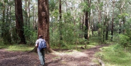
Ku-ring-gai Council is anticipating that there will be a strong demand for biodiversity offsets once biodiversity legislation comes into operation in August. At the council meeting on 13 June a decision will be made whether to support the adoption of the Biodiversity Banking and Offsets Scheme (BioBanking) as an ongoing biodiversity management approach within council owned or managed land classified as Community Land under the Local Government Act 1993. Public consultation to assess the community’s acceptance of the ongoing creation of BioBanking sites will take place before the scheme is finalised.
So far there is one BioBanking site at Rofe Park, Sheldon Forest and Comenarra Creek Reserve and a decision has been made for another site yet to be determined in respect of land clearing by the North Connex project. Ongoing BioBanking within council-owned or managed land will strengthen the protection of biodiversity values and increase the funds available for management activities which improve biodiversity conservation.
As pointed out in the council meeting papers and in the article about offsetting on changes under the Biodiversity Conservation Act 2016, the impacts of development within Ku-ring-gai could be offset elsewhere in NSW. This could be circumvented if offset lands are made available.
Also the new system is weaker in its requirements for like-for-like offset requirements. Plant Community Types (PCTs) which don’t exist within Ku-ring-gai could in some circumstances be offset with different PCTs occurring within Ku-ring-gai, creating further offsetting opportunities.
The selection of potential BioBanking sites in Ku-ring-gai will seek:
- to maximise landscape connectivity;
- to protect sites of high ecological value and resilience, as directed by council’s 2015–17 bushland prioritisation matrix; and
- to align with regional conservation priorities, including the Office of Environment and Heritage’s Biodiversity Investment Opportunities Map – this map identifies areas for investment within the Cumberland subregion, which include either core areas or biodiversity corridors of state or regional significance.
If you are interested in obtaining further information look out for developments on council’s website.
Adani Coal Mine – Surely it Can’t Go Ahead

The Australian and Queensland governments are still pushing for the Adani mine to go ahead and are bending over backwards to make this possible. The local native title holders are opposed but the Australian government is trying to legislate away the aboriginal rights.
We still haven’t heard if the Northern Australia Investment Facility will provide a concessional loan of $1 billion to finance the rail line from the Carmichael Basin to the port at Abbot Point on the Great Barrier Reef.
Queensland has offered financial inducements such as the deferral of royalty payments and no payment will be required for the mega litres of water that will be drained from the Great Artesian Basin. Local farmers are concerned about the effect on their water supplies.
Adani has announced a decision to go ahead in principle. But where will the finance come from when already 16 major banks have declined to participate? They can see that the project is not viable. When will reality hit the politicians?
There are many reasons why the mine will be a disaster:
- Adani has a dubious record that is hard to pin down due to complicated corporate structures and use of offshore tax havens.
- The chief benefit being promoted is jobs, jobs, jobs but realistic figures are for only about 1,500 full-time equivalent direct and indirect jobs as against the hype of 10,000 jobs.
- The Minister for Resources and Northern Australia, Matt Canavan, claims that the coal will bring the Indian peasants out of poverty. But solar energy has been shown to be more affordable.
- The mine is a total environmental folly. The opening of the Adani mine and construction of the railway line will open up the whole Galilee Basin that contains enough coal which, if burned, could blow away any hope of keeping global warming within 2°C and undermine any national and state action to tackle climate change.
- The mine threatens the Great Barrier Reef not only because of the increase in sea temperatures from climate change. The recent heavy rains led to coal washing into wetlands next to Abbot Point, the coal loader leased to Adani. Is this an example of worse to come?
- The mine would harm the economy of other coal mining states. The massive increase in production would reduce the coal price for coal mined in the Hunter Valley.
- The current rapid move to renewable energy is likely to reduce demand for coal to the extent that the coal market will collapse. The governments’ support could well be wasted.
Rodent Eradication on Lord Howe Island – A Case Study of Cost Benefit Analysis

Lord Howe Island is a magnificent island about 600 km off the coast of NSW. Its unique landform as an eroded volcanic peak and endemic biodiversity led to its classification as a World Heritage site. The southern end is dominated by the basalt peaks of Mt Gower (875 m) and Mt Lidgbird (777 m) covered in dense forests. The northern end is undulating and partially cleared for settlement. Lord Howe’s crescent shape embraces a sheltered lagoon and the southernmost coral reef on the planet.
The number of residents and visitors is limited by its small size and mountainous topography. Its economy depends on tourism and propagation and export of the kentia palm. The maximum number of tourists on the Island at any one time is constrained to 400 and the number of residents is about 350.
When I last visited the island in 2002 there was talk of a project to eradicate rodents. Rats and mice arrived in 1918 as escapees from a grounded ship. Rodents have contributed to the extinction of a number of species and are recognised as a threat to at least 13 bird species, 2 reptiles, 51 plant species, 12 vegetation communities and numerous threatened invertebrates.
The problem is that there is no native mammal species on the island that can compete with, or predate, on the rats and mice. Any impact on the natural values of the island diminishes tourism and recreation values since these are inextricably linked to the islands unique biodiversity and World Heritage values. (Attempts have been made to bring in other predators that are another example of the problems humans can cause when we interfere with nature – see the end of this article.)
Predation by rodents on kentia palm production reduces values associated with this commercial activity, via reduced production and added costs. In addition, rodents impose costs to residents and tourism operators via the need to bait to reduce visual presence of rodents, the spoiling of food stuffs and potentially health impacts to residents and tourists alike.
There has been a long process of investigation and consultation with concerned residents and I understand that the issues are still not resolved. The main problem is the acceptance of widespread use of poison baits. It is hoped that final approval will be granted later this year. The ABC Radio National Off Track program had two episodes on Lord Howe Island’s ecology during early June including discussion of the project and the damage being done by rats.
I recently discovered one of the reports on the project. The Economic Evaluation of the Lord Howe Island Rodent Eradication Project prepared by Gillespie Economics (November 2016). It is an interesting example of cost benefit analysis, the sort of analysis expected by government. As expected with an economic evaluation the report covers the financial aspects of the project. But it is also tries to quantify other community and environmental effects that cannot be directly related to money using some of the techniques of environmental economics.
Cost Benefit Analysis
Cost benefit analysis (CBA) provides a comparison of the additional costs and benefits with the rodent eradication project (REP), relative to without the REP. Provided the present value of additional benefits exceed the present value of additional costs, a project is considered to improve the wellbeing of society and hence is desirable from an economist’s point of view.
The net present value of a benefit or cost arising in the future takes into account the value of time through the process of discounting. The discount rate is a huge area of controversy. Business and government usually use commercial interest rates while society may consider a much lower rate is appropriate so that the interests of future generations are not discounted using the questionable theory that they will be better off than current generations.
A prime example is the issue of climate change – some argue that the costs borne in transitioning to renewable energy sources now do not justify the benefits of avoiding the loss of crops, bushfires, heat stress, sea level rise 50 or 100 years hence. If the benefits of avoiding costs in the long term are discounted at commonly used interest rates then the costs of transition today may exceed these benefits. Part of the problem is the broad assumptions needed to value loss of biodiversity and other environmental assets. The REP project analysis provides some examples of surrogate methods that are used. I will leave the reader to decide on the validity of the methods.
Scope of the REP
The Lord Howe Island Board currently implements a limited rodent control program at a cost of $85,000 per year. However, it is not reducing the rodent population sufficiently to limit landscape scale ecological impacts and there is a risk that continuation of the current approach will result in bait shyness and/or resistance in the rodent population.
The Lord Howe Island REP will use cereal baits laced with the anticoagulant Brodifacoum dispersed from helicopters in the uninhabited areas, and a combination of hand broadcasting, bait stations and bait trays in the settled area. Preparation is required to ensure some species are not killed by the baits. The iconic woodhens that were rescued from extinction and the local currarongs will have to be captured and caged for the period the baits are potent.
Without the REP, the current rodent control program would continue but this can only cover accessible areas of the island. The rodents have plenty of food sources all over the island. There would be continued presence of poison in the environment, continued impacts on the kentia palm and nursery industry, further degradation of World Heritage values (including endemic and threatened species) and the potential for Lord Howe Island to be inscribed on the List of World Heritage in Danger.
Cost Benefit Analysis Results
The analysis calculates that the present value of costs of the project and follow up management including measures to return species that are currently extinct from the island over 30 years is $9 million. By contrast the value of the benefits is $150 million. Hence this analysis shows that the economic value of the project is obvious.
Just looking at the cost of the project compared with ongoing costs of the current methods of control the net cost is about $8 million. Funding commitments have already been received from the NSW and Australian governments.
The removal of the effects of rodents on the kentia palm industry and vegetable production is valued at $1 million.
Some of the valuing of the benefits would be subject of much debate, for example:
- The improvement in biodiversity is deemed to increase visitor numbers. In warmer months when accommodation is already fully booked, increased demand is assumed to increase prices by 35%. In cooler months the accommodation demand is assumed to increase by 20% and prices by 7%. All this is assumed to have a present value over 30 years of $80 million.
- It is estimated that seven future extinctions will be avoided. The value of extinction prevention is based on several studies of community willingness to pay for the protection and recovery of threatened species. On an Australia-wide measure of community willingness to pay they are valued at $8 million each adjusted for a chance that the REP makes no difference to the chance of extinction to give a total of $40 million.
- There are also four species that are locally extinct, the Kermadec petrel, the white-bellied storm petrel, phasmid (stick insect) and wood-feeding cockroach. The return of these species is valued similarly with a deduction for the possibility of failure to reestablish the species at $27 million. One wonders if the general public would value the return of a species population by a transfer from another island in the same way as prevention of extinction of the only population of a species.
Even though some of these figures are debatable it is clear that the REP is worthwhile from an economic point of view. It is hoped that the local residents can be convinced of the benefits.
 A Further Complication – the Masked Owl
Not long after rats became a problem the authorities thought it was a good idea to introduce various owl species to control the rats. There is still a large population of Tasmanian Marked Owls. After the REP is completed their major food source will have disappeared so it is likely they will turn to other species. We don’t want more extinctions so a removal program will be required of these Masked Owls.
City Populations

There has been much media interest in the report that Sydney's population has reached 5 million. What has also been reported is that Melbourne’s population is growing faster than Sydney’s and may soon exceed it.
Sydney
The problem I have with this is that Sydney includes the Central Coast and the Blue Mountains, but not Wollongong. I don't advocate including Wollongong but leaving out the other two plus the Wollondilly Shire (Picton) we have 5.25 – 0.33 – 0.08 – 0.05 = 4.79 million. We could go further and leave out the farther reaches of Hornsby, Baulkham Hills and other local government areas.
Melbourne
Melbourne includes the Mornington Peninsular (0.16 million) which is debatable. Other areas should also be removed (allow 0.05 million). So, 4.67 – 0.16 – 0.05 = 4.46 million which is 93% of Sydney’s population.
Distortions
Part of the problem for the Australian Bureau of Statistics is that the outer suburban local government areas cover large areas of peripheral rural land. The Sydney map at a guess is at least 75% rural and this leads to massive distortions when people try to compare densities.
This data below (from Population Australia) is rubbish. Population Australia is a website specialising in research for Australia population growth trends and estimation. It is not clear who is behind this group but the data seems to be coming from the Australian Bureau of Statistics.
More on this some other time.
Position | City | Population density |
1 | Melbourne | 453/km2 |
2 | Adelaide | 404.205/km2 |
3 | Sydney | 400/km2 |
4 | Perth | 317.736/km2 |
5 | Canberra | 173.3/km² |
6 | Brisbane | 145/km2 |
7 | Hobart | 124.8/km2 |
8 | Darwin | 44.976/km2 |
Jim Wells has been delving into published statistics that are more than meets to eye.
Threatened Species Children’s Art Competition

STEP is supporting a great initiative by organised by Forestmedia, a small not-for-profit organisation that is aiming to increase community awareness of the plight of our threatened species and help to develop the next generation of environmental leaders. The children’s art competition is supported by a number of organisations including the National Parks Association, the Nature Conservation Council, WIRES, Featherdale Wildlife Park, Humane Society International, Animals Australia and Taronga Zoo.
The competition is open from 5 June to 4 August to all primary aged children in NSW and the ACT. Fifty finalists’ works will hang in a two week exhibition in September at the Botanic Gardens and Surry Hills Community Centre, with winners announced on 7 September, Threatened Species Day.
There will be prizes in several categories. STEP is sponsoring a prize for a nocturnal animal artwork. Last year’s prize winners are shown on the website. They are very impressive.
Biodiversity Legislation Submission – Major Points for Comment Relating to Urban Areas

In May the NSW government released regulations and codes that provide some of the detail on how the biodiversity legislation will operate in practice. But it is not complete so there is still a lot of uncertainty. The call for submissions is an opportunity to express a view on what should be in the areas that are missing as well as the available drafts.
There is a large volume of information to digest. The most useful one is the Submission Guide: Ecological Sustainable Development.
Consistent with STEP’s interests we focus on the aspects that relate to the management and preservation of urban bushland. Refer to our article on the issues regarding the Biodiversity Offsets Scheme.
The major areas that are missing are the Vegetation State Environment Planning Policy (Vegetation SEPP) and some of the maps that will underpin the decision-making process. This is most unsatisfactory! The legislation is due to come into force on 25 August. It is an abuse of due process to be conducting consultation on incomplete information.
The Vegetation SEPP will regulate clearing of vegetation in urban areas and environmental conservation/management zones where clearing does not otherwise require development consent under the main planning act, the Environmental Planning and Assessment Act. So the zones that are covered include E2, E3 and E4 zones.
The major concern is the inclusion of E2 zones in the clearing provisions. This zone is for areas with high ecological, scientific, cultural or aesthetic values outside national parks and nature reserves. The zone provides the highest level of protection, management and restoration for such lands whilst allowing uses compatible with those values.
E3 (environmental management) and E4 (environmental living) zones accommodate low-impact residential development but contain, or are near, bushland so have particular environmental or risk factors.
So why is the Vegetation SEPP regulating clearing on E-zone land, in particular E2 land? Clearing should not be allowed except for bushfire safety and other protection reasons.
Examples of land that could come under the new regulations are near the Blue Gum High Forest area in Dalrymple Hay Reserve and the area between Berowra Heights and Cowan near the Great North Walk. Most people assume the latter is national park but much of the natural scenery enjoyed by walkers is zoned E2, E3 and even RE1 (public recreation) and would have little protection under the proposed SEPP. Some E2 land is protected by being a BioBanking site or part of a conservation agreement, but not all.
Sensitive Biodiversity Values Land
There are certain areas, regardless of land area, that will require a biodiversity assessment (and offsetting if clearing is approved) if they are mapped in a Sensitive Biodiversity Values Lands map. The definition of areas included is very restricted.
Comment for submissions
The final map is not available and we understand many parts of NSW have not been properly assessed yet.
The resolution of the draft map on the website is too low to identify particular sites.
Areas that don’t meet the definition and should be included are endangered ecological communities (e.g. Sydney Turpentine Ironbark Forest and Duffys Forest EECs), buffer zones around EECs and areas of critical habitat, e.g. Ku-ring-gai Flying Fox Reserve.
Will it be possible to nominate areas for inclusion? Local land managers should be able to have a say on what is Sensitive Biodiversity Values Land.
There is a real danger that clearing of EECs such as STIF could rapidly turn it into critically endangered. A council’s discretionary DCP would be the only protection. It takes some time for a change in classification of vegetation communities to be finalised. In the meantime will they be cleared beyond hope of recovery?
Clearing Provisions
The clearing provisions are determined by categories of development.
Development consent required
Development consent is required (under the Environmental Planning and Assessment Act) for larger developments and infrastructure.
The Biodiversity Assessment Method (BAM) applies to clearing and the flawed offset provisions will apply.
Development consent NOT required
When development consent is NOT required, e.g. clearing of undeveloped land, the Biodiversity Offset Scheme (BOS) thresholds apply as prescribed below:
Minimum lot size | Proposed area of clearing |
Less than 1 ha (10,000 m2) | 2,500 m2 or more |
Less than 2 ha | 5,000 m2 or more |
2 to 39 ha | 5,000 m2 or more |
The thresholds are high.
For clearing above the threshold the BOS applies and approval will be determined by the Native Vegetation Panel. A biodiversity offset obligation will be imposed. Local councils could be given authority to do this assessment. We don’t know who will be appointed to the Native Vegetation Panel.
Clearing below the threshold will be regulated under the local council’s Development Control Plan (DCP) through a permit system. This will be the most likely situation in urban areas,
There is currently wide variation in the standards of DCPs, for example in relation to individual trees. Ku-ring-gai requires a permit for clearing of most native trees and vegetation and non-native trees while Hornsby only controls clearing of locally endemic native trees or trees in heritage zones. It is possible that the government will impose standard clauses in DCPs. Indeed would these be desirable if a high standard is applied?
Comment for submissions
It is essential that the objectives of clause 5.9 of the standard LEP are carried over to DCPs under the new scheme that is ‘to preserve the amenity of the area, including biodiversity values, through the preservation of trees and other vegetation’.
Submissions should explain desirable standards for the DCP regulations. One area that has not been covered is how the DCP clearing codes will fit in with the need for wildlife corridors and the Greater Sydney Commission’s guidelines for the Green Grid and minimum tree canopy cover.
Other Impacts of Clearing Regulations
A major issue with the local regulation of clearing is that there will be no monitoring of loss of vegetation communities and assessment of cumulative impacts. There needs to be a database of regional clearing approvals.
There is uncertainty about the legal status of DCP regulations and the ability to prosecute if breaches occur.
Areas of western Sydney that will be subject to the greatest amount of new development need as much protection as possible of native vegetation and habitat. The Cumberland Plain Woodland has already had large areas cleared. The allowable clearing and the use of offsets under the proposed regulations will further reduce the area of remaining native vegetation and habitat.
Conclusion
Given the limited areas of bushland in urban areas, it is inevitable that there will be more losses of irreplaceable biodiversity. The offsets provisions do not adequately factor in the scarcity of suitable offsets in urban areas (see article below). The rules must be amended to ensure maximum protection of native vegetation in urban and E zones, particularly areas containing threatened species.
Please Send a Submission
Closing date: Wednesday 21 June. Lodge online or post to Land Management and Biodiversity Conservation Reforms, Office of Environment and Heritage, PO Box A290, Sydney South, NSW 1232.
Assessment of Biodiversity Offsetting – A Fail and Worse to Come

Over the past 200 years NSW has lost almost half of its bushland through land clearing and only 9% of what is left is in good condition. Clearing of native vegetation and habitat modification are the greatest threats to the survival of the majority of species on the threatened list.
The biodiversity laws that the government passed in late-2016 place a great deal of emphasis on offsetting as a means of allowing development to occur. The theory is that biodiversity lost when clearing for a development can be replaced by providing for restoration or protection of biodiversity in another place.
The Nature Conservation Council recently published a report on the operation of NSW’s biodiversity offset schemes, called Paradise Lost: The Weakening and Widening of NSW Biodiversity Offsetting Schemes, 2005–16. This article outlines the key findings of the report.
As you can tell from the title, the principles of offsetting have been severely compromised. We can expect worse to come under the new laws.
Concept of Biodiversity Offsetting
Biodiversity offsetting has been in use in NSW since 2005 under various pieces of legislation.
One example is the money that was paid by NSW Transport Infrastructure Development Corporation to compensate for the loss of 0.33 ha of Blue Gum High Forest when the railway station at Hornsby was expanded. The money was used to help purchase land to expand the area of protection of Blue Gum High Forest next to Dalrymple-Hay Nature Reserve.
The basic principles that should be observed are given below.
Offsets hierarchy
Offsets should only be used after appropriate avoidance and minimisation measures have been taken according to the mitigation hierarchy. A biodiversity offset is a commitment to compensate for significant residual adverse impacts.
No net loss
A biodiversity offset should be designed and implemented to achieve measurable conservation outcomes that can reasonably be expected to result in no net loss and preferably a net gain of biodiversity.
Some areas should be off limits – red flags
There are situations where residual impacts cannot be fully compensated for by a biodiversity offset because of the irreplaceability or vulnerability of the biodiversity affected.
Consider whether restoration is possible
Biodiversity offsetting assumes ecosystems and habitats can be re-created. This is often not the case, particularly if offset sites have been highly degraded and lost essential characteristics. In Australia, a number of studies have shown revegetated areas rarely resemble the ecosystem it was intended they would replicate.
Timing mismatch
It takes some time for species to establish a viable population in a new habitat. Offsetting should allow for a phased-in approach to prevent the total loss of species that are already threatened. The loss of hollow-bearing trees is a particular example.
Stakeholder participation
In areas affected by the project and by the biodiversity offset, the effective participation of stakeholders should be ensured in decision-making about biodiversity offsets. All stages including their evaluation, selection, design, implementation, monitoring and communication of results to the public should be undertaken in a transparent and timely manner.
Long-term management
The design and implementation of a biodiversity offset should be based on an adaptive management approach, incorporating monitoring and evaluation, with the objective of securing outcomes that last in perpetuity.
Case Studies
There are five types of offsets schemes operating in NSW. The performance of each of these schemes was examined through the lens of eight case studies:
- Namoi catchment property vegetation management plans – approval for land clearing under the Native Vegetation Act
- Kellyville in northwest Sydney – creation of credits under the BioBanking scheme
- Wagga Wagga local environment plan – biodiversity certification for strategic planning
- Albury local environment plan – biodiversity certification for strategic planning
- Huntlee development in Hunter Valley – Office of Environment and Heritage principles for biodiversity offsetting
- Boggabri and Maules Creek coal mines – development consent – Office of Environment and Heritage principles for biodiversity offsetting
- Warkworth mine extension – Office of Environment and Heritage principles for biodiversity offsetting
- Mt Owen mine expansion – NSW biodiversity offsets policy for major projects
The report provides a detailed description of the features of each case study and compares them with the expected standards. The criteria for the analysis were:
- be a last resort after avoidance and mitigation (including appropriate ‘red flags’)
- deliver biodiversity equivalence (like-for-like)
- provide security and achieve benefits in perpetuity
- deliver a net gain in biodiversity
- be additional to conservation measures already in place
- be enforceable, resourced and well-managed
- be subject to a rigorous monitoring and evaluation framework
- be open and transparent
It was demonstrated that biodiversity offsetting is failing to deliver the environmental outcomes promised. No case studies resulted in outcomes deemed ‘good’ and the outcomes were:
- ‘disastrous’ in one study (Boggabri/Maules Creek)
- ‘poor’ in five studies (Warkworth, Mount Owen, Huntlee, Albury, Kellyville)
- ‘adequate’ in two studies (Namoi, Wagga Wagga)
For more details read the report.
Comparison of Offset Schemes
The report considers that a scheme should have the following features:
- excludes discounting of offset credits
- excludes supplementary measures
- excludes mine rehabilitation
- clear standard for environmental outcomes
- does not allow payment in lieu of offsets
- red flags
- impacts on water quality and soil are taken into account
- like-for-like offsetting
The case studies demonstrate the features of the five biodiversity offset schemes in operation. It was found that the later models contained fewer best-practice principles and standards than the earlier ones:
- only the first offsets scheme (the Environmental Outcomes Assessment Methodology under the Native Vegetation Act) contained all eight features
- the Biodiversity Offsets Policy for Major Projects introduced by the Baird government in 2014 contained only one of the eight features
Overall, biodiversity offsetting schemes have failed to deliver the promised outcomes and they have become weaker as standards have slipped.
Draft Biodiversity Offset Scheme is Even Worse
The latest Draft Biodiversity Offset Scheme (BOS) and the Biodiversity Assessment Methodology (BAM) that will be used to determine offsetting does not include any of the features described above.
The BAM is a metric-based tool that allows biodiversity impacts and improvements to be assessed and quantified in terms of ecosystem credits and species credits, collectively known as biodiversity credits that will need to be offset.
The proponent can choose to between three methods of meeting their offset obligation:
- buying credits for a suitable site under the offset rules from the market, or they can establish a Biodiversity Stewardship Agreement on their own land and retire the credits generated
- make a payment to the Biodiversity Conservation Trust that will source the offsets
- paying for conservation actions as approved by the consent authority
Key points for submissions
The key points on the features that should be in the offsetting legislation and the changes that are needed are listed below.
1. Discounting of biodiversity credits should not be permitted
The government proposes introducing ‘discounting’ that will allow offset credit requirements to be ‘discounted’ based on claimed social and economic benefits. Economic prioritisation policies are likely to contribute to the incremental and permanent loss of significant biodiversity in NSW, and undermine the credibility of the policy.
2. Supplementary measures should not be included
The BOS allows the use of ‘biodiversity conservation actions’ that may include research or surveys into the biodiversity under threat. This is not a genuine offset. The Scientific Committee stated in a report on this idea that this:
… is clearly a case of developers being able to buy themselves out of any obligation to protect biodiversity in any meaningful way.
NSW Scientific Committee (2014) Submission on the Draft NSW Biodiversity Offsets Policy for Major Projects
3. Allowance of mine rehabilitation
Numerous critics have questioned whether degraded mine sites can be effectively restored and in any case mine site rehabilitation should be an obligation of the mining company. Recently, developers have been permitted to use mine rehabilitation sites to generate biodiversity offset credits. The government proposes continuing this practice under the draft BOS.
4. Clear standards
The Biodiversity Conservation Act requires that the biodiversity assessment method should adopt a standard that result in no net loss but the draft BAM does not have a clear objective to protect biodiversity.
5. No payment in lieu
The draft BOS would allow proponents to discharge offset requirements simply by paying money into Biodiversity Conservation Trust. The development could proceed without certainty that the required offset is possible.
6. Red flags
The BOS does include some restrictions on proposals that cause ‘serious and irreversible impacts’ (SAII) but the criteria for defining SAII are too weak. It includes only the most endangered and restricted area species and ecological communities. In the case of major projects the SAII risks can be ignored. The net effect will be that EECs and endangered species not listed in the list of SAIIs, e.g. STIF and Duffys Forest, could be cleared without offset requirements if the land area is below the clearing thresholds. A council’s discretionary DCP would be the only protection.
7. Other impacts on water and soil
Other impacts should be considered in the BAM. The assessment methodology covers only a limited range of biodiversity values such as vegetation integrity and habitat suitability but not soil health and water quality and availability.
8. Like-for-like principle
The like-for-like principle that offsets should replace the values being lost is undermined in several aspects. For example:
- Offsets can be found from a radius of 100 km. It will be easier and cheaper to find offsets outside urban areas undermining preservation of biodiversity and threatened species and EECs such as STIF. The loss of existing geographic distribution if sites in urban areas are lost will undermine species resilience and long term adaptation to climate change.
- Offsets can be used for species across similar vegetation classes or between species. This even applies to threatened species; a koala can be swapped for a wallaby.
Conclusion
The government is proceeding with this model despite warnings expressed by leading scientists, lawyers and conservationists. The government basically has ignored the advice of the experts because it is wants to deliver development at any cost. Implementing the BOS will in fact add extinction pressures to the very species and ecological communities it is supposed to protect by facilitating the more rapid and widespread destruction of threatened species habitat across NSW.
Please Send a Submission
Closing date: Wednesday 21 June. Lodge online or post to Land Management and Biodiversity Conservation Reforms, Office of Environment and Heritage, PO Box A290, Sydney South, NSW 1232.
More...
Some ways Citizens can Help Science

Hollows as Homes
The Australian Museum has joined the Royal Botanic Garden Sydney and Sydney University in launching a new citizen science project called Hollows as Homes. Funding support is provided by the Australian government.
The project builds on the Cockatoo Wingtags project and involves the same researchers, led by Dr John Martin.
In urban and agricultural areas large, hollow-bearing trees are in decline, but many species of animal rely on tree hollows for shelter and breeding.
In NSW, hollow-dependent species include at least 46 mammals, 81 birds, 31 reptiles and
16 frogs. Of these, 40 species are listed as threatened with extinction. This is why the ‘loss of hollow-bearing trees’ has been listed as a Key Threatening Process to biodiversity throughout Australia.
One reason that their loss is significant is the length of time that it takes for a tree hollow to form (often more than 100 years). More hollow-forming trees are needed to replace the losses that have occurred already. The solution being trialled is to create artificial hollows and nest boxes.
The Hollows as Homes project aims to conduct the first landscape scale assessment of tree/nest box/cut-in hollow distribution, type and wildlife use. Data generated will inform council plans for retaining important habitat trees, planting future habitat trees and supplementing missing habitat.
The project will harness the enthusiasm of local residents to report, measure and monitor tree hollows in their backyards, streets and parks.
Participating is easy – check the trees in your backyard, street, park, paddock or the bush, and report the hollow(s) online.
FeralScan
Feral animals cause over $720 million damage each year in Australia and threaten our native wildlife. FeralScan allows you to help reduce feral animal damage by mapping feral animal sightings, damage and control activities in your local area.
Ferals covered by the program include Indian Mynas, foxes, rabbits, feral cats and many more invasive species.
Gas is not the Solution for Transitioning our Energy Supply away from Coal
Following the serious power blackouts that occurred in South Australia and near misses in other states, gas-fired power stations have been touted as the one of the best means to transitioning away from our aging coal-fired electricity generation system. This is short-term, simplistic thinking that will be detrimental in the longer term, and the Climate Council has just released a report explaining why. The report is called Pollution and Price: The Cost of Investing in Gas.
The Climate Council is the crowd funded organisation led by Tim Flannery that replaced the Climate Commission that was abolished by the Abbott Government shortly after they came into power. They aim to provide independent, expert information on climate change issues.
Here is a brief summary of the main findings.
Use of gas does not reduce emissions sufficiently
Australia must reduce greenhouse gas emissions down to zero by 2050 in-line with international goals. Fossil fuels (coal, oil and gas) all produce greenhouse gas emissions driving climate change. Limiting global temperature rise requires that they are all phased out. Gas is not sufficiently less polluting than coal to garner any climate benefit.
Greenhouse gas emissions are produced both from gas power stations and gas production (for instance, methane from gas leaks). Methane is 86 times more potent as a greenhouse gas than carbon dioxide over a
20-year period.
New gas power plants are less polluting than coal. However, when the entire supply chain of gas production is considered, gas is not significantly less polluting than coal. Current levels of reliance on gas power in Australia must be reduced to play our role in limiting global temperature below 2°C. Expanding gas usage is inconsistent with tackling climate change as it locks in emissions for decades into the future.
Greater reliance on gas will drive higher power prices
Australia’s liquefied natural gas exports are pushing up the price of gas power as domestic gas prices are now inextricably linked to world market prices for oil. This will continue into the foreseeable future.
The most economic and accessible reserves are now being exported. Further gas expansion will drive increased reliance on unconventional gas, which is expensive. Reliance on gas power is also driving power price spikes, particularly in South Australia, Queensland and increasingly in New South Wales, due to lack of competition among gas power companies.
Investment in new gas plants is financially risky
The large increases in future gas prices and volatility resulting from liquefied natural gas exports together with domestic gas prices controlled by relatively few producers, make investments in new power plants using gas very risky. New gas power plants would rely on ageing gas production infrastructure (e.g. processing plants and high pressure pipelines) that is increasingly vulnerable to failure. Costs of updating this infrastructure and accounting for methane leakage must be factored into policy and investment decisions.
New gas infrastructure locks in carbon emissions for decades. Future regulations may impose higher costs or stricter limits on emissions in the future, impacting on the economic viability of gas production and electricity generation, stranding investments.
Significant development of new gas plants is unfeasible without a massive expansion of unconventional gas
The sheer volume of gas required, the cost, the lock in of long-term emissions, environmental risks and lack of support from communities near gas wells makes this unrealistic. Currently the emissions from unconventional gas in Australia are unknown due to a lack of measurement and data. This presents a long term carbon risk to investors as high emissions fossil fuel infrastructure faces the possibility of future regulation due to climate change. Development of new unconventional gas is entirely out of step with meeting the Australian government’s climate change goals.
Renewable energy can provide a secure, affordable alternative to new fossil fuels
New renewable energy is cost competitive with new gas. The cost of renewable power and storage, particularly solar, wind and batteries, continues to fall and has no associated fuel costs. This contrasts with rising and volatile gas prices.
Technologies such as solar thermal, hydro and biomass plants can meet demand for electricity at all times of the day as well as meeting technical requirements for grid stability. Combining these technologies with wind, solar PV, and large-scale energy storage, can meet electricity demand round-the-clock. Using existing gas-fired generators and supply infrastructure prudentially to complement wind and solar power while scaling up a range of renewable energy technologies, energy storage and energy efficiency measures could deliver a limited benefit, provided the end goal is phasing out the use of all fossil fuels as quickly as possible.
Conclusion
The report concludes that Australia should not provide policy support for new gas power plants or gas supply infrastructure. Existing gas plants should be thought of as a short-term, expensive, emergency backup as renewable energy and storage is rapidly scaled up.
Bubbles not Balloons

Every day there’s an outdoor event to celebrate or commemorate something or other, and balloons will be released. It looks spectacular for a moment or two, but they’re soon forgotten. What happens to them? Most end up in our seas, where they are eaten by marine wildlife, including seabirds. It sounds frivolous, but it’s become a major conservation problem.
BirdLife Australia has thrown its support behind a campaign by Zoos Victoria and the Phillip Island Nature Parks to shine a spotlight on this issue.
Most people aren’t even aware that the simple act of releasing balloons into the air poses a major danger to wildlife. However, the facts are startling. A CSIRO study found that balloons are in the top three most harmful pollutants threatening marine wildlife – along with plastic bags and bottles.
Albatrosses, cormorants, penguins and pelicans are all affected by this, but of all Australia’s seabirds, shearwaters, or muttonbirds, are the most badly affected when it comes to ingesting plastic debris.
For example, the decline of Flesh-footed Shearwaters on Lord Howe Island has been directly linked to the ingestion of debris, with balloons and their plastic attachments, one of the most prevalent and readily identifiable items found inside them. Further, two separate studies have found that 100% of Short-tailed Shearwaters contain plastic in their digestive systems.
The balloons fill the birds’ digestive tracts while offering no nutrition, and slowly poison them as toxic chemicals leach into the birds’ tissues.
Birdlife Australia is joining Zoos Victoria and Phillip Island Nature Parks to encourage Australians to make their outdoor events wildlife-friendly. The best way to do this is by choosing to use bubbles instead of balloons to reduce this source of harmful waste.
Help spread the word to use bubbles instead of balloons at outdoor events. It’s a simple act but it can make such a big difference.
This information comes from Birdlife Australia.
Further reading:
St Ives Showground Precinct – a Tourism Centre for Ku-ring-gai?

Ku-ring-gai Council has commissioned a report on developing the tourism potential of the municipality. Ku-ring-gai Destination Management Plan 2017 to 2020 is open for submissions until Friday 12 May.
The report focuses on a plan:
… to redevelop the St Ives precinct to achieve a ‘wow factor’ to attract visitors, benefit residents and help grow the local visitor economy.
The aspirations presented in the report are:
- to develop the precinct as a distinctive destination for nature-based and Aboriginal cultural tourism experiences
- to establish the precinct as a unique trekking hub and gateway for adjoining national park trails and Hawkesbury River to Sydney Harbour linkages to achieve similar iconic status as the Three Capes Track in Tasmania
- to develop events infrastructure and supporting facilities to position the precinct as centre for international-standard performances similar to those staged at the Hope Estate in the Hunter Valley for music, cinema and performing arts
- to rebrand the precinct to reflect its competitive advantage and world-class potential (e.g. Centennial Parklands and Western Sydney Parklands)
- to commission a revised master plan to balance existing recreational and community activities with a new tourism focus under a trust governance model used elsewhere
- to achieve the precinct’s full potential as a seven day a week, four seasons integrated mixed-use destination for international and domestic visitors
Accommodation Proposals
The possible developments described are more prosaic. Many of the suggestions are for the upgrading of existing facilities but STEP would be concerned by proposals for:
… unique accommodation experiences that complement these experiences (e.g. a five-star eco-tourism lodge sited near the boundary of the national parks escarpment, hostel accommodation for education and recreation groups and flash-camping).
Details are needed on how this sort of development can be achieved without damaging the environmentally sensitive E2-zoned land including endangered the Duffys Forest Ecological Community. The map at the top of the page also seems to show some national park land as being within the precinct. STEP will be looking at these plans very closely.
The report does acknowledge the environmental constraints:
It should be recognised that the recommended strategy, focused on nature based and Aboriginal cultural tourism, has environmental protection and enhancement at its core. There are numerous examples around the world of sensitively designed accommodation and infrastructure within and adjacent to national parks and areas of high ecological value. It is proposed that all new development in the St Ives precinct will be sensitively designed, constructed and operated in accordance with best practice and there should be a net improvement to environmental performance on site such as increased biodiversity, improved drainage runoff, Aboriginal cultural interpretation and signage. It should also be appreciated that many parts of the St Ives precinct are in a degraded environmental condition.
Walking Tracks
Proposals to upgrade walking tracks within the precinct and links to Ku-ring-gai Chase and Garigal National Parks are welcome. Many of the existing tracks are degraded and unattractive because of weed infestations. Funding has always been a problem, both for council and National Parks and Wildlife Service. This highlights the perennial problem, where will the money come from? It seems that public private partnerships and commercial leases are the only hope.
National Parks Development
The report (p19) states that the NSW government is about to release a new master plan for national parks covering partnerships with nature-based tourism stakeholders. A draft new Plan of Management for Ku-ring-gai Chase National Park is due to be released this year. It is going to be another busy year for preparing submissions.
Old Nursery Site
The plan for an indoor sports centre at the site of the nursery does not get a mention. Has that idea fizzled out? Instead there is mention of a native wildflower nursery funded by the private sector.
Road Links and Parking
The report highlights the need for traffic lights and a pedestrian crossing at the main entrance on Mona Vale Road. It also suggests that the exit at the Wildflower Garden be closed with internal roads being used to gain access via the main showground. There is a suggestion for overflow parking on the other side of Mona Vale Road. The effects of car parking on the Duffys Forest vegetation and soils has always been a problem and is currently controlled by the use of bollards and parking restrictions. If the number of visitors is to increase significantly the control of parking will be more important than ever.