
Sydneysiders are lucky to have several national parks within easy reach of suburbia. Their existence is thanks to a situation where much of the land was too steep or inaccessible to build on in the early days. However the bushland was the setting for plenty of activity before its value for conservation and public benefit was recognised. Bantry Bay is a prime example.
Garigal National Park in only 8 km from the centre of Sydney. It covers about 2,200 hectares of bushland, comprising the valley of Middle Harbour Creek and its tributaries extending as far north as Mona Vale Road at St Ives, the slopes along the northern side of Middle Harbour as far as Bantry Bay and Wakehurst Parkway. The largest part is in the catchment of Narrabeen Lakes.
Bantry Bay is the only bay in Sydney Harbour that is not readily accessible from the land because of steep valleys, but access by water is a different story. Bantry Bay is the last deep water inlet to retain the character similar to that before European settlement.
The first European incursion into Bantry Bay was a bullock track, down which timber from Frenchs Forest was hauled to a wharf on the eastern side of the bay and shipped to other parts of the harbour.
In 1879 the Bantry Bay area was set aside for public recreation. By the start of the 1900s, the eastern side of Bantry Bay had been turned into a popular pleasure ground, complete with dance hall, picnic ground, a dining room and several summer houses. The Balmain New Ferry Company, operated by John Dunbar Nelson, promoted the area as a secluded, scenic and romantic retreat for the residents of an increasingly urban Sydney.
Early in the 20th century the safe storage of explosives became a concern. Bantry Bay was surveyed as a possible site because of the ease of transport by water and its seclusion. While Bantry Bay solved the thorny problem of where to safely locate a magazine complex in Sydney, it alienated the reserve from the public to whom it had been originally dedicated. Despite a storm of protest, including from the newly-created Warringah Shire Council, the land was dedicated for explosives storage in 1908.
The site was expanded over the years, in particular during World War I. The magazines were operated by the state government. They stored explosives for public works, including the Sydney Harbour Bridge and underground rail tunnels, and commercial purposes such as mining.
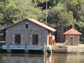
The site was taken over by the Allied Forces during World War II. Its final development comprised various magazines where the explosives were received, sorted and stored as well as an office, two jetties, numerous sheds and testing laboratories.
After the war, the difficulty of site access and the cost of maintenance led to the site’s closure in 1964 and since then the site has mostly been allowed to deteriorate.
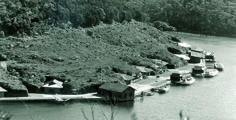
 The hillside above the magazines that is covered in low vegetation in the photograph is now fully revegetated and the area is fenced off. The easiest place to see the old magazines is from the other side of the bay at Wharf picnic area.
The buildings on the western side of Bantry Bay are architecturally significant both for their rare and specialised design and as examples of the public utility architecture of Federation Sydney, most of which is now either gone or threatened. They have been classified by the National Trust (1975).
A detailed description of the significance of the complex of buildings is set out in the draft Conservation Plan of Management (see details below). It identifies the Receiving Magazine as the most significant structure on the site but acknowledges that it may not be possible to repair. The design of the buildings is such that they cannot be adapted for a wide variety of uses without their significance being compromised. Access difficulties and the current lack of utilities may also cause problems for anyone interested in re-using the site. However they could be accessed by a trail from the Magazine Track or from a jetty.
Sources
Manly Daily (2016) The Former Explosives Complex that is now Part of a National Park
MacRitchie, J (2008) Bantry Bay, Dictionary of Sydney
Garigal National Park Plan of Management (2013) NPWS
Bantry Bay Conservation Plan of Management (draft) (2002) prepared for the NPWS by Graham Brooks and Assoc, Taylor Brammer Landscape Architects, Mary Dallas Consulting Archaeologists
Photo at the top of the page is Bantry Bay in 1972 (source Manly Daily 22 September 2017)
Jill Green