

Campaigns (22)
Spanish moss
Control
 We found no mention of an obvious biological control. Overseas examples of control include hand removal and spraying with potassium or sodium bicarbonate or copper sulphate.
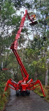
Hand removal is often recommended as the best way to control Spanish moss but in our survey only approximately 12% was within easy reach. Rakes, ladders, professional tree climbers, industrial vacuum cleaners and specialised equipment such as spider lifts and elevated platforms would be needed in many infestations.
Spanish moss has been underestimated as a threat. We recommend that it be added to the next iteration of the Greater Sydney Regional Strategic Weed Management Plan, not be distributed or sold, and be added as a separate threat to Sydney Turpentine-Ironbark Forest in the Sydney Basin Bioregion.
Widespread education about its potentially disastrous impact on some bushland communities and urban forests is urgently needed through gardeners, horticulturalists, bushland managers and professional organisations.
Also, research is urgently needed into the ecology of Spanish moss, why it flourishes on some trees and not others, the ecological consequences of its presence as well as control methods suitable to Australian ecosystems and conditions.
Spanish moss
Recommendations
Individuals
Remove all reachable festoons in your garden and put them into the green bin.
Control all festoons in garden trees by other means, e.g. spraying when safe effective methods have been established.
Do not give Spanish moss to friends, neighbours, passers-by and the local community.
Join campaigns to alert the local community and authorities to the threat posed by Spanish moss to bushland and gardens.
Authorities
Control authorities, e.g. state government, local councils, local land services and National Parks and Wildlife Service to urgently remove and control Spanish moss.
Educate the community about the threat posed by Spanish moss to bushland.
The Threatened Species Scientific Committee needs to add Spanish moss as a specific threat to the Critically Endangered Sydney Turpentine-Ironbark Forest.
Regulatory
Spanish moss must be added to:
- the next iteration of the Greater Sydney Regional Strategic Weed Management Plan and all other relevant regional strategic weed management plans
- these plans at a classification level that enables its eradication and containment, prohibition of sale and distribution, e.g. as a regional priority weed
Research
Immediate research is needed into:
- why Spanish moss flourishes on Turpentine, Brush Box and other rainforest species but not on most eucalypts
- the ecological consequences of infestation on individual trees and native plant communities
- the rate of growth and variation of growth with weather
- safe effective control options in Australian conditions
- fire ecology
Education
Education about the threat posed by Spanish moss to bushland through:
- TAFE NSW and private vocational providers – Spanish moss must be included on weed lists for horticultural, landscape, conservation and ecosystem management courses
- community groups – conservation groups (many are members of the Nature Conservation Council), gardening clubs (many are members of Gardening Clubs of Australia), Landcare, Greening Australia
- professional organisations – Australian Association of Bush Regenerators, The Society for Ecological Restoration Australasia, Ecological Society of Australia, Australian Institute of Horticulture
- gardening media – TV gardening and home improvement programs such as Gardening Australia, radio programs, magazines such as ABC Gardening Australia Magazine, Landscape Architecture Australia, Australian House & Garden
- social media – Facebook groups such as NSW Introduced Plant Identification and Bush Revegetation and Regeneration
Spanish moss
Findings
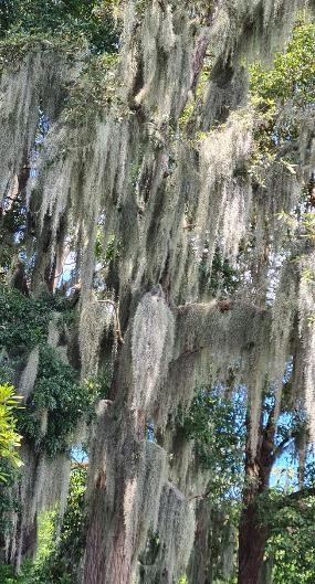
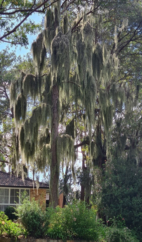
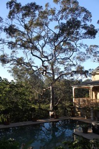
Spanish moss can grow almost anywhere, but during our survey it was obvious it flourished on some tree species and not others. Our observations indicate that the leachate from the host, or epiphytic species such as lichens and fungi, may be a determining factor for Spanish moss success. Spanish moss was recorded on trees from 32 plant families and 65% of records were from the Myrtaceae (Myrtle) family where turpentine and brush box dominated recordings. Of all the eucalyptus in the northern suburbs only one, red mahogany, was recorded repeatedly carrying substantial amounts of Spanish moss.
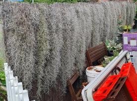
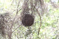
Festoons commonly occurred in the middle layer of the support plants (60%) and almost 90% were out of easy reach. Branches were the most common support (56%) followed by leaves, but only 12 host species (26%) were involved, primarily turpentines. Festoons were mostly 0.5 to 2 m long but some extended over 3 m. Sparse infestations were the norm (48%) but most individual festoons were dense.
Dispersal rate appears to have been slow with people and animals the main dispersal agents over long distances, but many observations indicate that the spread, density and size of festoons is increasing exponentially. It is no longer a sleeper weed.
Spanish moss
Description
Spanish moss, commonly known as Old Man’s Beard, is a perennial monocotyledon in the pineapple family that grows abundantly from the Southern United States to the cooler regions of Argentina and Chile. It tolerates a huge range of temperatures and annual rainfall.
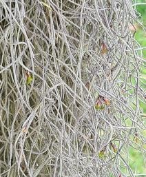
Spanish moss is an epiphyte that forms hanging festoons up to 8 m long which loop over branches and catch in cracks and crevices in bark to start new festoons. The festoons are made up of numerous shorter plants twisting around and overlapping each other.
It grows slowly, is not allelopathic nor drought tolerant, has low fertility requirements, is a medium moisture user, requires a pH of 6 to 6.9, has no salinity tolerance and is shade tolerant.
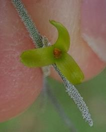
The small green flower is present from spring to autumn. The fruit is a capsule up to 25 mm long but we failed to find any mature fruit from November 2023 to June 2024. The flower rarely successfully self-pollinates. The seed is uncommon and is produced in autumn and winter. Seeds have feathery parachutes that enables them to float like dandelion seed. Seeds have no seed dormancy and can spread up to approximately 250 m away from the nearest Spanish moss but spread is not rapid under normal conditions.
The surface of Spanish moss plants is covered with tiny, grey scales (trichomes) that trap water and nutrients which then move by capillary action on the outside of the plant. Vascular transport is unimportant. Rain, dew and fog are more important than relative humidity. Water loss is reduced by crassulacean acid metabolism photosynthesis that allows gas exchange at night. In the Southern United States, Spanish moss is often found by ponds as clearing, frequent fires and barriers of dense pines prevent growth elsewhere. It generally grows best in high light conditions.
Spanish moss
An environmental weed
In the early 2020s STEP became increasingly concerned about the potential impact of Spanish moss on our bushland and so we asked members to send us details of any Spanish moss growing on trees. In November 2024 we published the results of our findings in a report entitled Spanish Moss (Tillandsia usneoides): An Environmental Weed. A Preliminary Assessment in Northern Sydney.
We concluded that Spanish moss must be treated as a serious environmental weed otherwise turpentines, lilly pillys and other rainforest trees will turn into grey curtains of swaying Spanish moss. Local plant communities that are likely to be infected include the critically endangered Sydney Turpentine-Ironbark Forest, Blue Gum High Forest and Sydney Enriched Sandstone Moist Forest.
Threats to ecosystems include causing the death of individual trees by reducing photosynthesis but also include subtle effects such as altered water and nutrient cycles, changed predator prey interactions, habitat alteration, moderation of the microclimate and transformed fire regimes. Changes such as these are one of the greatest conservation threats to biodiversity in Australia.
Spanish moss will be expensive and difficult to control as most of it is out of easy reach. The sooner gardeners, park and natural area managers commence a coordinated program of removal the cheaper and more effective it will be.
Protecting Powerful Owls
Coalition membership
The Powerful Owl Coalition is a group of concerned community environmental groups working in collaboration with the Powerful Owl Project of Birdlife Australia.


This page is hosted by STEP on behalf of the Powerful Owl Coalition
Protecting Powerful Owls
More information
Birdlife Australia's Powerful Owl Project
Download a flier and give it to your friends and neighbours to read
Download our position paper paper which is designed to educate and encourage all levels of government, professionals, groups, communities and individuals to protect and increase the number of Powerful Owls in urban areas
Powerful Owl Submission to the Sydney North Planning Panel on the Redevelopment of Hornsby Quarry (May 2020)
Email us at This email address is being protected from spambots. You need JavaScript enabled to view it.
This page is hosted by STEP on behalf of the Powerful Owl Coalition
Protecting Powerful Owls
Why they need our help
Human actions are causing a decline in numbers through development on bushland fringes, removal of trees and vegetation and road deaths
They are a threatened species — there may be as few as 5000 in the world
Their habitat supports amazing wildlife, enriches our lives and connects us with nature
Future generations deserve to see these birds in the wild
How you can help
Download a flier and give it to your friends and neighbours to read
Download our position paper paper which is designed to educate and encourage all levels of government, professionals, groups, communities and individuals to protect and increase the number of Powerful Owls in urban areas
Make your garden Powerful Owl friendly
Submit sightings to This email address is being protected from spambots. You need JavaScript enabled to view it. (give the time, date, place, any interesting details and, if possible, attach a photo or recording)
Contact your local council and politicians if you become aware of inappropriate development or clearing
This page is hosted by STEP on behalf of the Powerful Owl Coalition
Protecting Powerful Owls
How to make your garden owl friendly
Maintain and protect your old trees and value your trees hollows — they’re homes for frogs, possums, sugar gliders and birds
Install a nest box
Plant native trees and shrubs
Plant understorey trees and shrubs to support prey species
Plant shrubs in dense, continuous groupings for birds
Don’t plant climbers and plants close to trees as they can damage the bark
Keep thick mulch away from with tree trunks
Avoid changing soil levels under tree canopies to maintain healthy tree roots
Employ reputable arborists to prune trees (you may need council permission)
Plant a gum tree, but not too close to your house, for future generations of Powerful Owls – you will also enjoy its beauty, wildlife and shade
Protect Ringtail Possum dreys (they look like footballs made of twigs)
Reduce hard surfaces such as paving
Let’s enhance our lives too
Residential areas with mature trees and canopies are more desirable and therefore valuable, than those without
By planting and caring for your trees and shrubs you will:
- reduce the temperature of your home thus saving money on cooling
- beautify your home
- improve your streetscape
- increase the amenity of your local area
and all the while you will be protecting Powerful Owls! What’s not to like?
This page is hosted by STEP on behalf of the Powerful Owl Coalition
Protecting Powerful Owls
What do they need to survive?
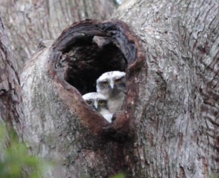
Huge old growth trees more than 80 cm in diameter, with hollow entrances of 40 cm or more
Roosting trees with dense canopies, particularly near rivers, creeks and gullies
Foraging areas of complex vegetation large enough to support abundant prey species such as possums and birds
Urban green spaces, bushland and leafy gardens
Safe flight paths through bushland and urban areas
Humans to help them survive and thrive
This page is hosted by STEP on behalf of the Powerful Owl Coalition
More...
Protecting Powerful Owls
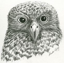
Do you know that they ...
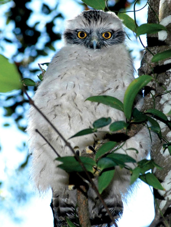
Are Australia’s largest owl
Are an icon of the Australian night
Are charismatic, impressive birds
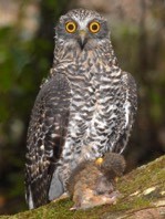
Top predators which help to keep our ecosystems in balance, e.g. by controlling possum populations
Are only found along Australia’s east coast
Live for up to 25 years in the wild
Have long and strong partner bonds
Grow up to 60 cm in height
Have a wingspan of up to 140 cm
Have striking yellow eyes
 Have large orange feet with strong, sharp talons
Are brown and white with brown chevrons on a white chest
Chicks have downy white chests and grey masks
Nest in large hollows of trees over 150 years old
Have a delightful low ‘hoot hoot’
Need to eat approximately one possum (or flying fox) per night
This page is hosted by STEP on behalf of the Powerful Owl Coalition
Protecting Powerful Owls
Why they need our help
Human actions are causing a decline in numbers through development on bushland fringes, removal of trees and vegetation and road deaths
They are a threatened species — there may be as few as 5000 in the world
Their habitat supports amazing wildlife, enriches our lives and connects us with nature
Future generations deserve to see these birds in the wild
How you can help
Download a flier and give it to your friends and neighbours to read
Download our position paper paper which is designed to educate and encourage all levels of government, professionals, groups, communities and individuals to protect and increase the number of Powerful Owls in urban areas
Make your garden Powerful Owl friendly
Submit sightings to This email address is being protected from spambots. You need JavaScript enabled to view it. (give the time, date, place, any interesting details and, if possible, attach a photo or recording)
Contact your local council and politicians if you become aware of inappropriate development or clearing
This page is hosted by STEP on behalf of the Powerful Owl Coalition
 History of the UTS Site
The land was privately owned until 1915 when the Commonwealth Government acquired it during the First World War for the army’s use as a rifle range.
It was acquired by NSW in 1961 'for and on behalf of Her Most Gracious Majesty Queen Elizabeth II for the purposes of the Public Instruction Act of 1880'.
The site was developed as William Balmain Teachers College and opened in 1971. Construction had been delayed by protests by local residents about destruction of bushland on the site and later, with the backing of Ku-ring-gai Council, by protests about the problems of traffic in the narrow streets. The architect, David Turner, stated that his main design aim was to keep the college as compact as possible, because the landscape was so wonderful it should not have been built on. When it was going ahead anyway, I thought I’d protect the environment all I could'.
In 1974, along with the other teachers colleges, William Balmain Teachers College officially closed. It then became Ku-ring-gai College of Advanced Education, a corporate body with its own council. It was no longer tied to the Education Department. However it did not own the campus land which remained vested in the Crown.
UTS Aquisition, the Access Road and Railway Station Imbroglio
After changes in the education system, on 1 January 1990 the campus became part of UTS. The campus remained Crown land until they and the other universities involved finally acquired the titles which were issued on 1 December 1994 for a fee of $1. From FOI papers obtained it appears that title was only granted to UTS and the other universities on the condition that:
... the site continues to be used for the same academic purposes.
In 1990, UTS lodged a development application with council for construction of an access road from Lady Game Drive through the environmentally sensitive College Creek area. A committee was formed and STEP's representative, who has a civil engineering background, proposed an alternative route through a less sensitive area. Over the years UTS submitted several revised development applications, as a result of very protracted negotiations, community meetings and submissions involving UTS, Ku-ring-gai Council, the National Parks and Wildlife Service, environmental groups and residents. Eventually in 1998 Ku-ring-gai Council granted conditional development consent, demanding that UTS produced a much needed Bushland Management Plan for the grounds. However this never occurred and the development consent expired.
The cause was the Parramatta to Chatswood railway link and the proposal for a station at UTS, which would provide the additional access necessary and thus cancelled the need for an additional access road.
Unfortunately, the planning and review process for the rail link concluded that a station at UTS was not economically viable. UTS had prepared a forecast of an increase to 6600 students by 2006, however economic consultants for the Department of Urban Affairs and Planning indicated even an increase to 11,500 students would not make the construction financially viable.
Furthermore, the Environmental Impact Statement noted:
The UTS site is also located at the tip of a peninsula, with only one access point through surrounding residential streets, in a bush fire prone area. Some of the environmental planning issues associated with expansion of the campus on this site are able to be resolved, however the major concern of traffic and transport impacts on the adjacent area still needs to be addressed. The strong concerns and opposition of local councils and local residents over any proposed campus expansion is also a critical issue that needs to be noted.
Dilapidation of the Campus
After abandonment of the access road and railway station proposals, UTS stated that the campus was suffering because staff and students no longer wanted to go there. In June 2005, Fay Pettit was able to write:
There have been a great many indications that for some time the Ku-ring-gai campus is being deliberately run down and its education function undermined.
Fay went on to give nine examples including the exclusion of the campus from UTS annual reports, the withdrawal of lecturers, the closing down of the popular evening courses and the neglect of maintenance. The campus is now in a sad state of dilapidation: a state that one may conclude arose from the university wanting it that way.
Part 3A of the Environmental Planning and Assessment Act
In late 2005, the NSW Government amended the Environmental Planning and Assessment Act (1979) with the addition of Part 3A. The Environmental Defender's Office NSW published a paper which stated:
In effect, Part 3A of the Act dramatically reduces the involvement of the community in the original decision-making process and seeks to reduce any risk of concerned individuals or groups delaying or preventing significant development by limiting the grounds on which, or the circumstances in which, they can seek merits or judicial review. Instead, the Minister for Planning and the Director General, Department of Planning, maintain the power to make all key decisions regarding significant development, with advice from 'expert panels', limited input from other key agencies and little opportunity for effective criticism where the bureaucracy 'gets it wrong'.
In March 2007, CRI wrote to Frank Sartor, the Minister for Planning, requesting that he call in the UTS redevelopment and rezoning application using his powers under Part 3A.
STEP viewed this request as a tacit admission that the local community and Ku-ring-gai Council had rejected the proposal and thus these voices need to be sidelined.
On 14 June 2007, Frank Sartor registered the proposal as significant and pursuant to Schedule 1 of the State Environmental Planning Policy (Major Projects) 2005 and is thus declared as to be a project to which Part 3A of the Environmental Planning and Assessment Act 1979 applies. The Department of Planning thus listed the UTS development on their Register of Major Projects.
Stringybark Ridge
 Stringybark Ridge, once the site of a long abandoned pony club, is part of the Berowra Valley National Park (BVNP). The main parties involved seemed then to be in agreement that this is how it should remain. All NSW national parks are governed by a legally binding Plan of Management (PoM).
2005
After more than two years of community consultation with a wide range of local sporting and recreational groups, neighbours and other community groups a new Regional Park PoM was supported by both Hornsby Council and NPWS. This PoM stated that the main recreational use of the park was for bush walking, with some provision for limited dog walking on three management trails.
2006
Hornsby Council, after a careful review of potential sports grounds in the Shire, adopted a Sports Facility Strategy Plan, which specifically discounted the possibility of ever again using the old pony club site for active sporting purposes. All of which would seem to indicate that the future of Stringybark Ridge as an easily accessible urban lung for the local community, rather than as a basis for team sporting ovals, was assured.
2012
Despite the agreements reached above, then mayor, Nick Berman, unilaterally wrote to local state MPs asking for their support for the Stringybark Ridge site to be made available to provide additional team sporting facilities for soccer, cricket, AFL, netball and ‘other sports’, including attendant amenity blocks and spectator support arrangements and parking (see STEP Matters 165, p2–4 for full details of the ensuring events).
March 2015
NPWS issued a new draft PoM which, while specifically required under the relevant legislation ‘to protect and conserve’ the area, in point of fact proposed a spectacular reversal of their own previous policy.
Page 18 identified Stringybark Ridge as a potential area for a number of purposes, including ‘activities of a recreational, sporting, educational or cultural nature’ and Hornsby Council proposed building change rooms, amenities buildings, kiosks, parking and to erect tower lighting. The facilities would be used both mid-week and over weekends.
The draft PoM went on to state that NPWS would, in consultation with the community and Hornsby Council, prepare a precinct plan for Stringybark Ridge to articulate the specific activities and facilities for future use, including possible planned future use.
Our comments focused on our two main concerns, the proposed sporting fields on the two open grassed areas of approximately 2 hectares in size to the east of Schofield Trail, Stringybark Ridge, Pennant Hills and the potential mountain bike options for the park.
February 2023
The final PoM was adopted by the Minister for Environment and Heritage on 2 February 2023 ... an interval of eight years! In the PoM:
- the provision of sporting facilities has not progressed, but it has been identified as a potential site for recreational, educational and cultural activities
- other options include camping to support use of the Great North Walk and/or an area for community activities
We have many criticisms about the quality of the plan, for example the:
- geology section needs to be re-written with a correct balance between geology, landscape and soil
- naming and detail of species is inconsistent
- fish and mangroves are completely overlooked despite them being such important ecosystems
Click here for our response to the PoM.
A precinct plan is now being prepared to examine opportunities for future use and vegetation restoration. Vehicle and public access arrangements for Stringybark Ridge will be determined as part of the precinct plan.
STEP will be keeping an eye out for the precinct plan as our objection to sporting facilities was not about the sports per se but about the possible ecological impact of development.
STEP's Position
Undeveloped ridgetops are particularly rare and valuable in the valleys of the Lane Cove River and Berowra Creek, and we consider that the simple fact that it is a ridge makes Stringybark Ridge of conservation significance.
In 2015 STEP argued that the construction of sporting fields and mountain bike tracks would destroy the value of Stringybark Ridge as habitat and as a corridor. Stringybark Ridge is an integral part of the corridor from the Parramatta River to the Hawkesbury River as it the closest point to Lane Cove National Park. Nomadic and migratory fauna, as well as dispersing young, all need safe corridors for survival of the species.